
The Ultimate Pamir Highway, Tajikistan Travel Guide (2024)

- Last Updated: February 5, 2024
Everything you need to know about travelling the Pamir Highway in Tajikistan. A detailed travel itinerary, how to book a car and driver, things to do along the way, where to stay and how much it will cost.

Basketball-sized stones rained down on us from the roadside cliffs above. The earth shook violently, and the sound of exploding dynamite echoed down the valley.
We stopped in our tracks and stared fearfully across the narrow Pamir River. 30m from us was Afghanistan’s Badakhshan province, which was currently under the attack of Taliban rebels.
We looked at Mohammed and waited for his instructions. Our guide simply laughed. “The Afghans are building a road.”
The Pamir Highway is one of the world’s greatest road trips . Unofficially starting in Mazar-e-Sharif in Afghanistan and unofficially ending in Osh in Kyrgyzstan, this captivating route was once part of the historic Silk Road.
Weaving between soaring mountains and along sprawling desert, the trek that today makes up the majority of people’s exploration connects Osh to Khorog, a small town in the heart of the Pamir Mountains.
Highway M41 rises over the second highest border crossing in the world and hits the border of Tajikstan and Afghanistan before cutting in on a direct route to Khorog.
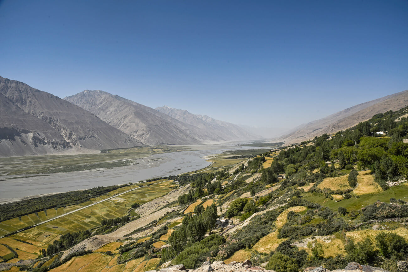
At this point most people continue along the border and into the infamous Wakhan Valley , flanked by the Pamir Mountains on one side, and the Hindu Kush on the other.
BREAKING NEWS: Registrations are now open for our NOMADasaurus Pamir Highway and Tajikistan Tour in 2024!

No images or stories can prepare you for just how beautiful the Wakhan Corridor is. For as many days as you care to take you traverse the fine line between two misunderstood nations.
Tajikistan is more remembered for its civil war and as a major heroin trade route than anything else. The problems of Afghanistan are well-documented and often overstated.
Still in this narrow passage all one can think about is how surreal its scenery is.
We spent 7 days travelling along the Pamir Highway in September 2015, renting a 4×4 in Osh with two other travellers. This is our route, tips and stories from our amazing road trip along the roof of the world.
Table of Contents
Getting a Tajikistan Visa and GBAO Permit
Public transport, hitchhiking the pamir highway, things to do in sary moghul, where to stay in sary moghul, things to do in karakul, where to stay in karakul, things to do in murghab, where to stay in murghab, things to do in bulunkul, where to stay in bulunkul, things to do in langar, things to do in yamg, where to stay in yamg, why we didn’t stay in langar, things to do in yamchun, where to stay in yamchun, things to do in khorog, where to stay in khorog, exchanging money on the pamir highway, camping along the pamir highway, extending your pamir highway adventure, pamir highway from dushanbe or khorog.
- Getting The Tajik Visa And GBAO Permit
- How To Travel The Pamir Highway
- Day 1 – Osh To Sary Mogol
- Day 2 – Sary Moghul To Karakul
- Day 3 – Karakul To Murghab
- Day 4 – Murghab To Bulunkul
- Day 5 – Bulunkul To Yamg
- Day 6 – Yamg To Yamchun
- Day 7 – Yamchun To Khorog
- Budget For The Pamir Highway
- Camping Along The Pamir Highway
- Extending Your Trip
- Travelling From Dushanbe Or Khorog
When we travelled through Tajikistan we had to acquire a visa in advance. In addition to this if you want to travel along the Pamir Highway you must also get a permit for the Gorno-Badakhshan Autonomous Oblast (GBAO) region.
We did this at the embassy in Bishkek in less than a day for $62 ($60 for our 45-day double entry Tajik visa, and $2 for our GBAO permit for the same length of time).

However we now have good news! Most people can now obtain an e-visa for Tajikistan, including the GBAO permit! The cost is US$70 for a 45-day single entry visa that can be used at all border crossings and international airports.
Click here to apply for your Tajikistan e-visa.
Note: If you want a double entry visa (to travel into Afghanistan’s Wakhan Corridor for example) you still need to apply at the embassy. We recommend the one in Bishkek .
How to Travel the Pamir Highway
There are a couple of ways to travel the Pamir Highway, and all of them have their ups and downs. It really depends on your travel style and budget.
BIG UPDATE – We originally used Osh Guesthouse to book our 4×4 Pamir Highway Tour, but during our latest trip to Kyrgyzstan talking to tourism directors we were informed about a new company which has better vehicles, experienced drivers and can organise a perfect itinerary. In fact Osh Guesthouse approached them this year to partner together, they are that good. For that reason we now recommend you to get in contact with Talant from Visit Alay to book your trip along the Pamir Highway. He speaks perfect English and is passionate about delivering a great experience. He has also been trained by USAID in tourism product development, which is the organisation we worked with from 2016-2020 in Kyrgyzstan, Uzbekistan and Tajikistan. You can pre-book the vehicles and drivers now before you arrive in Bishkek, Osh or Dushanbe, which saves a lot of headache.
This is the option we went with and recommend. Having your own transport and driver allows you to go at your own pace, stop for photos and breaks and have a bit of comfort as well.
We organised our 4×4 rental from Osh Guesthouse in Osh, Kyrgyzstan. This place has become quite famous for helping travellers plan their Pamir Highway road trip, and the owner is friendly and willing to provide assistance.
He also speaks great English and has all the connections sorted, so even if you aren’t staying there it’s worth dropping by to speak to the owner.

When renting a 4×4 you will be charged per kilometre. This sounds pretty crazy, and to be honest it is. But that’s just how it works down here. You also pay a small daily stipend for your driver.
You will plan out your route (distances are already known) and any side trips you want to take in advance. Any additional kilometres driven will be charged extra, and must be paid for in cash directly to the driver.
You must also pay for the driver to return to Osh, charged at a lower rate if you wish to exit in Khorog or Dushanbe (unless he happens to be from Khorog or Dushanbe).
If you don’t have a group of 4 people, we recommend putting your name on the board in Osh Guesthouse saying you are looking for extra people to join you on the Pamir Highway. This will help keep your costs down. You can also do a call out on the Caravanistan forum .
One of the guys who we travelled with had actually been in Osh for a week already waiting to find people to join him on the trip.
Unfortunately every time a group came in they were already a 4, so he had to bide his time until he could find more travellers.
This isn’t always the norm, but something to keep in mind if you are showing up in Osh and expect there to be hundreds of people to jump in with.
Of course if your budget allows you can go by yourself or as a 2 or 3. This is totally up to you.

This is actually one of the worst ways to travel the Pamir Highway, but completely doable if on a tight budget.
Transport isn’t comfortable or regular from Osh to Khorog, and you can expect to spend a lot of hours crammed into a dilapidated marshrutka bouncing over horrible roads staring out of a closed, dirty window. But it’s all part of the adventure, right?
Public transport on the Pamir Highway is definitely possible if you’re more interested in the scenery outside the window as opposed to the side adventures that can be had along the way.
You can get a minivan from Osh to Murghab in one day, and then take local rides into the Wakhan Corridor. However if you do this we highly recommend you split the trip from Osh to Murghab into two days, with a night in Sary Tash, due to the huge rise in elevation.
It is very possible to get altitude sickness, as you’ll be going from around 1000m up to 4655m in one day.

Absolutely doable, and we met quite a few people hitchhiking. One thing to keep in mind is that once you enter the Wakhan Valley most of the traffic will be from people who have rented vehicles, tours or shared taxis – not the kind of people who will pick up some hitchhikers for free
That being said with patience and persistence you can find rides to get you hitchhiking the Pamir Highway and Wakhan Valley.
If you have your own car or motorbike self-driving the Pamir Highway is probably the absolute best experience you can have!
The roads are horrible and the going is slow, but having the time to go at your own pace is something you will really relish.
Obviously the chances of picking up a decent car or motorbike in Central Asia isn’t huge, so if you’re considering this option you probably will be looking at bring your own vehicle from Europe.

This is it – the Holy Grail for cycle tourists. The second highest international road in the world and some of the most challenging and beautiful scenery imaginable.
We lost count of the number of cyclists we saw peddling the Pamir Highway, and almost all we had met after they had completed it said it was one of the best experiences of their lives.
We are not cycle tourists , so can’t give advice on this. But definitely check out Crazy Guy On A Bike for some great tips about it.
This is the most expensive option for travelling the Pamir Highway, but it might also be the best (depending on your point of view).
There are quite a few companies that offer Pamir Highway tours, and these are all in excess of a few thousand dollars. The main benefits are you get a newer, comfortable and reliable vehicle, an English-speaking guide and all the logistics are covered for you, so you can literally just focus on taking epic photos and soaking up the culture.
If it’s in your budget or you’re the kind of person who doesn’t like landing in a foreign country without everything pre-planned a group tour on the Pamir Highway is a good choice.
But in our experience you can do it much, much cheaper and get the exact same experience by doing it yourself .

Day 1 – Osh to Sary Mogol
Starting our seven-day adventure from the Kyrgyz city of Osh, our driver Mohammed picked our group of four up in his Mitsubishi Pajero and headed towards the Tajikistan border.
It only took a few hours from Osh before the landscape changed from craggy fields to steep alpine gorges. The famed Pamir Mountains began to rise all around us; speckled at first, then gradually becoming more dramatic.
At the border town of Sary Tash, where one road leads to China and the other to Tajikistan, we took a detour and instead stopped off in Sary Mogol for the night.
Peak Lenin stood 7134m tall in the distance, its permanent snow-capped summit looking like a water painting in the afternoon sun.
Mohammed dropped us at the CBT Guesthouse and we wasted no time in exploring the rugged Soviet-esque village.

Despite being a popular stopover for trekkers and alpinist who wish to summit Peak Lenin, our presence generated an excited interest with the young community.
Kids and adults alike would call our greetings from their windows and men would stop to ask us where we were from.
Passing a game of football between some local children, we were eagerly recruited and took part in a 30-minute match in a dirt yard.
Abandoned cars and trailers were scattered throughout the village – a sight that would become common along the Pamir Highway.
Before night fell we returned to the guesthouse for a large vegetarian meal and fell asleep on the floor, surrounded by other travellers and trekkers just as thrilled at being in such a beautiful part of the country.

There aren’t a lot of things to do in Sary Moghul itself, but it acts as an amazing launchpad for some of Kyrgyzstan’s best adventure activities.
For those who are experienced in high-altitude trekking, a summit attempt of Peak Lenin is perhaps the most incredible opportunity in the country.
This is one of the easiest 7000m+ peaks in the world, and besides an immense level of fitness and stamina, no advanced mountaineering skills are required.
Don’t be lured into a false sense of security though – it is still a very dangerous hike if you aren’t properly prepared! Consider going on a guided tour (you should already know if you think you could tackle this on your own).
Sary Moghul also acts as a great base for trekking in the surrounding mountains, and organising horse riding adventures. Check with the CBT Guesthouse for routes, ideas and information.

We stayed at the CBT Guesthouse and enjoyed it. It was the most expensive place along our Pamir Highway road trip, but it was quite high quality.
For US$20 per person we got a night’s accommodation, a large vegetarian dinner and a typical Pamiri breakfast (bread, jams, tea, etc).
We slept on a thin mattress on the floor with about 15 other people in the room. If you want to camp they also have places to pitch your tent.

Day 2 – Sary Moghul to Karakul
Morning came quickly and we set off with Mohammed towards the international border. Exiting Kyrgyzstan was a simple affair, providing that the correct ‘fees’ were paid to the officers.
Mohammed took our passports to be stamped out and returned happy, but with his wallet visibly lighter.
A 25km section of ‘no-man’s land’ separates Kyrgyzstan and Tajikistan, and is the second highest international border crossing in the world. It is not uncommon to see cycle tourists camping in this dead zone, unable to make the crossing in one day.
Entering Tajikistan was much the same. Our visas and special GBAO permits were checked and Mohammed took care of the legalities. When he returned he sighed. “Immigration, narcotics, medical, police, customs, they all want bribes. You pay them money, no problem. You don’t pay, you wait all day at the border.”

Seeing as we were now cleared to enter Tajikistan, it was clear that Mohammed had paid the unofficial fees to make our passage easier. We asked him much he paid. “Too much,” was his response.
The first village we reached in Tajikistan was Karakul, named after the sprawling lake on its edge. We chose Sadat’s Homestay to be our resting place for the night.
With welcoming hosts, and only $12 per person including a bed, lunch, dinner and breakfast, it was simply splendid.
The village was quieter than Sary Moghul, and after walking along the lake’s shore we found ourselves at a decrepit prison, complete with the shell of an old Russian tank near its perimeter.

Our group decided to break through a hole in the fence to explore further. Suddenly a soldier called out and came sprinting over to stop us, Kalashnikov in hand.
We stopped dead in our tracks and slowly showed him that we were unarmed, and simply curious tourists. Luckily he used his mouth rather than his gun to warn us that this was not actually an abandoned prison, but an active military base. We apologised and quickly returned to the village.
The reason the base looked so empty was because the soldiers were in the town, playing volleyball with the villagers. We stopped to watch their game, made small talk with the army and then returned to Sadat’s Homestay for dinner and bed.

Besides admiring the beautiful lake, there isn’t actually a lot to do in Karakul. As mentioned we tried to break into the prison, which turned out to be an active military base, so we don’t recommend that.
Simply walk around and enjoy the atmosphere of the village. It makes for some beautiful photos. Have a chat to the locals, and if you’re lucky you might even catch a volleyball match.
If you’re in Karakul for longer you can do some hiking around the flats and up to the mountains. Just make sure you stay well away from the Chinese border, which is quite close to the village.

We stayed at Sadat’s Homestay, and it was absolutely brilliant! The lady running it, Sadat, is very welcoming and makes some delicious food. Look out for the blue fence on the right hand side of the village when looking at it from the road.
The cost was also the cheapest we came across on the entire Pamir Highway – $12 per person for lunch, dinner and breakfast. We were the only people there and slept on the floor next to a wood-fired stove.
There are other options in Karakul, and our driver tried to make us stay at another one for $15 a night. However we got the feeling it was his friend’s place and kept walking around, and were stoked that we found Sadat’s.

Day 3 – Karakul to Murghab
That’s what we awoke to on a chilly Wednesday morning. Light at first, but soon the snowflakes got heavier and began to coat the village in a brilliantly white layer.
It was only the beginning of September, but already winter was coming fast in the mountains.
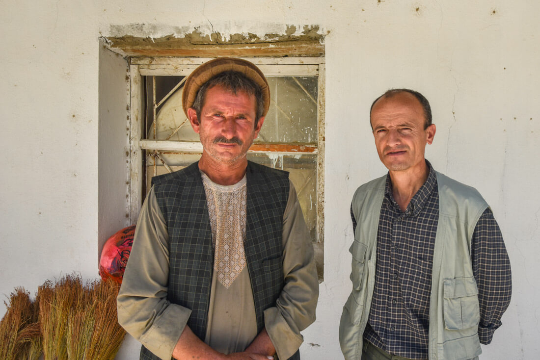
We wandered around Karakul before breakfast, and life was continuing as usual. Ladies were collecting water from the well, kids were running off to school and the men were getting ready to head into the fields to tend for their livestock.
We said goodbye to our friendly hosts and set off in a blizzard towards the south. It was only another short drive to the region’s largest town, Murghab.
Anywhere else in the world Murghab would be a blip on the map, but here in the GBAO it was the major trade and transport hub for the region.

Between Karakul and Murghab is the Akbaytal Pass, the highest point along the entire Pamir Highway. At 4655m above sea level, it’s not uncommon for people to feel lightheaded when climbing it.
Eventually arriving in Murghab we checked into the famous Pamir Hotel and treated ourselves to our first shower since leaving Osh.
The list of attractions of things to see in Murghab is limited to the local bazaar, operating out of shipping containers, and the small mosque.
Still, it was a nice place to wander, and after a few hours we found ourselves back at the hotel playing card games and sipping on Tajik beer.
Almost every other foreigner we met was a cycle tourist, many who had ridden to Tajikistan from Eastern China or Western Europe, giving an idea of the type of adventurous souls you meet on the Pamir Highway.
We met a young Australian man named Harley who had ridden is Suzuki dirt bike all the way from his home in Queensland. Clearly Tajikistan is not somewhere you encounter those seeking a relaxing vacation.

Walking around the container market is perhaps the best thing to do in Murghab. You can buy just about anything you would need there, from fresh vegetables to mobile phones and everything in between.
If you head out towards the back of Murghab you can find a small mosque. This is worth checking out as well. Otherwise just work your way through the streets then make the most of the comfortable accommodation back at the Pamir Hotel.

The Pamir Hotel is on the main road and is the largest accommodation in town. It is also the first one to fill up, as it offers decent meals and the first hot showers out of Osh.
The cost was $25 per night for a large room with shared bathroom. Naturally when we arrived there was no running water, so the minute it turned on there was a huge rush to jump in the shower. But as promised, the water was hot!
There are other home stays you can find on the outskirts of town. Stop by the META office (similar to the CBT in Kyrgyzstan) to find out more.

Day 4 – Murghab to Bulunkul
The scenery exiting Murghab quickly changed to become rockier and more imposing. We beelined it for Bulunkul, which has the solemn reputation of being Central Asia’s coldest town.
After Karakul’s snow only two days earlier, we feared the worst, but luckily for us the weather was delightfully sunny.
Bulunkul could be considered less of a village and more of a collection of mud-brick dwellings. It looked like the set of an armageddon movie.
Busted trailers and vehicles were dumped in random places and mud-brick homes were propped up with random pieces of scrap metal.
Still with the snow-capped mountains in the background it made for a stunning and intriguing scene.

We made our way to a homestay, cooked our own lunch and left Mohammed to drink tea with the family while our group trekked up a nearby hill to get a glimpse of Yashilkul Lake.
Reaching the top of the rise we were met with Yashikul Lake’s turquoise beauty shimmering in the daylight. A sign warned us that special permits were required to trek any further, so instead we aimed our sights towards the closest peak.
20 minutes of scrambling brought us to the summit, and our efforts were rewarded with near-360 degree views of the entire valley. We snapped our pictures before escaping the wind and heading back towards the village.
Yaks wandered around and kids played games. We soaked up the atmosphere for a while longer before retiring for the night.

Definitely trek up to the nearby Yashikul Lake and admire the immense beauty of the region. If you have permits you can continue trekking for days, and we wish we had more time to do so.
Get up for sunrise and catch the small ponds and lakes perfectly still on a calm morning.

We stayed at the main homestay in town. We can’t remember the name of it, but it’s owned by the guy in charge of the meteorological station in town. Just look for the big weather station on the roof. Your driver will know it.
The cost was $15 per night with dinner and breakfast included. The food was superb, and the sleeping quarters were similar to everything else we had encountered – a thin mattress on the floor.

Day 5 – Bulunkul to Yamg
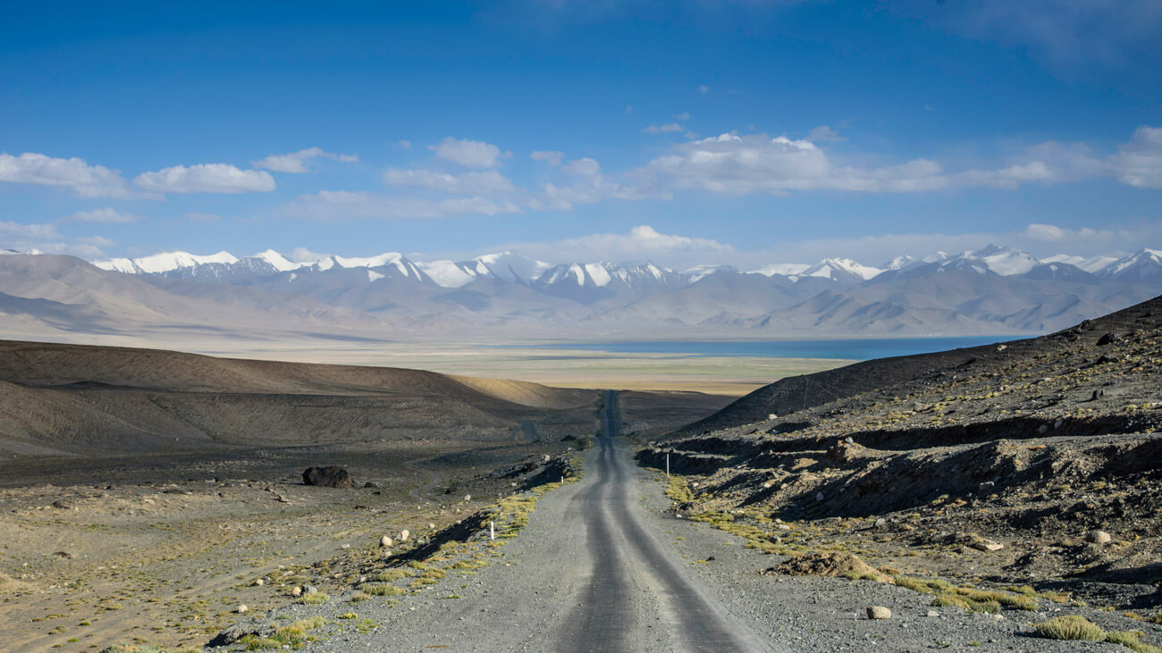
Our fourth day was destined to be the most spectacular of all. Here we would leave the M41 Pamir Highway and join the stretch of road that follows the Afghan border along the Wakhan Valley.
Before we reached the security control point we spotted “Panorama Peak” on our left, a steep ridge that our cycling friend Nick has told us about. Mohammed parked the Pajero and left us to trek on our own.

It took almost two hours of an uphill battle to reach the peak, the rocky terrain made even more dangerous with the altitude. At 4500m above sea level exerting your body at this height can bring about lethal altitude sickness.
Our fitness levels were up to the challenge, and we managed to reach the summit without incident.
The views we gained were what people come to this region for. In the distance the infamous Hindu Kush, the “Killer of Hindus”, formed an impenetrable mountainous barrier throughout this strange stretch of land in Afghanistan.

30km away was Pakistan, on the other side of this “corridor” that had been carved out by the Soviet’s during The Great Game in the early 1900s.
The Hindu Kush has been the intrigue of great explorers for centuries, and here it was towering in front of us.
The descent from Panorama Peak was quick and soon we were back in the Pajero and at the GBAO checkpoint.
At this point the Pamir River creeps into the scene, only 10m wide at some points, forming the official border between Tajikistan and Afghanistan.
We drove a few kilometres further and were soon following the meandering waterway for the rest of the journey.

Mohammed parked his car and allowed us to snap photos of Afghanistan. In the hills we could see farmers and small mud-brick houses, and two-humped Bactrian camels wandered along the banks of the river.
Afghanistan was so close, quiet and picturesque. We asked Mohammed if we could swim over to take a photo looking back at Tajikistan. He shook his head. “Big trouble for you.”
I looked around. “But there is no one else here.”
He whispered, “The army. They are watching.” And with that grim warning, we continued on our way.

For hours we followed a flat route in the shadows of the Hindu Kush. The river gradually grew wider and more powerful as tributaries rushed in from alpine glaciers.
The beauty we encountered behind every rounded bend took our breath away faster than the climb to Panorama Peak.
Soon the road climbed high into the mountains, following the contours of the cliffs. Any lapse in concentration from Mohammed would have resulted in us tumbling to a final resting place far below.
Luckily he remained attentive and cautious.

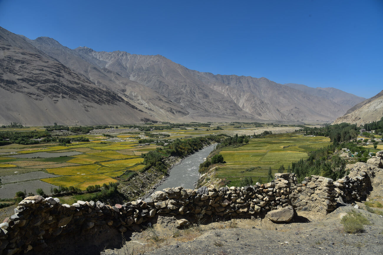
Dropping down towards the town of Langar we saw the lush farmland of the Wakhan Valley, stretching in from hidden regions of Afghanistan.
Langar is home to an ancient fort and megalithic petroglyphs, and its location could not be any more inspiring. After exploring the sights we opted to make the most of the daylight and move onto the smaller village of Yamg.

We stopped over in Vrang to climb around the quarry-like rock walls and to explore one of the region’s most interesting sites*, a Buddhist shrine.
Here some young boys approached us and bowed their heads in a respectful way, miming that of Buddhist monks. We allowed them to take us there and were surprised when they ran off without asking for money
Arriving late into Yamg night had already begun to fall, and Mohammed took us to Aydar’s Guesthouse. Aydar is the leader of the village, and spoke decent English.
His guesthouse felt less like an authentic homestay and more like a business, and we were eager to move on the next day. In the morning we walked around Yamg’s quaint streets and moved towards Yamchun, less than an hour on.
*Our good friends Thomas and Veronika recently used this guide on their own travels, and have reported that they were very underwhelmed with the Buddhist shrine. Perhaps we may have been too generous with our appraisal of it.

There are countless things to do in Langar, and for most people this is why they end up spending the night here. It also is a more logical spot to stop in terms of time spent on the road.
About 3km before Langar, make sure you check out the Ratm Fort, an old relic from the Silk Road that has great views over the Pamir River (now turning into the Panj River) and into Afghanistan.
You can walk around past the family’s house to get to it. Just make sure you watch your footing when stepping close to the edge inside the fort – there are plenty of loose stones.
If petroglyphs are your thing then climb into the hills to find over 6000 of them. To get there go to the school, follow the powerlines up the hill towards the cemetery, then keep going up until you can cross the small stream.
There’s also some Islamic shrines scattered around the village. It really is quite picturesque, and easy to see why people stay here.

There’s also quite a few cool things to do in Yamg. There is the Yamg Wakhani Museum, dedicated to local legend and Sufi mystic Mubarak-i Wakhani. You can find old musical instruments and relics of his life here.
Near the museum is a solar calendar as well. To be honest we didn’t visit any of these due to a bad taste left by our homestay owner (who also happened to manage all the attractions in town), so we simply walked around the beautiful, bucolic village.

We stayed in Aydar’s Guesthouse, but we don’t necessarily recommend it . It was overcrowded with group tours when we arrived, and while Aydar was smiling when we first got there, he made a big deal about how we were inconveniencing him by coming so late and tried to charge us $20 for a place on the floor there, with dinner and breakfast being extra.
When we asked for a cheaper price he got aggressive, saying that he had the best guesthouse in town and that if we didn’t like it we could leave. So we grabbed Mohammed to leave, and Aydar dropped the price to $15*.
During dinner Aydar’s son gave us a very nice and detailed explanation of Pamiri architecture, which was fascinating. He then asked for money for his explanation.
We refused, and he asked if we’d like to stay after dinner to watch a cultural dance his sister was doing. Sure, we replied. “It is only a $10 donation to watch the dance,” was his response. We went to bed instead.
In all honesty the place wasn’t bad – there was a shower, the mattresses were comfortable and the food was great. It just felt like a money-grabbing business trying to take advantage of tired travellers.
Others have stayed there and enjoyed it though, so perhaps we just got them on a bad day.
*(We asked to pay in Tajik Somoni, and he gave us the worst rate ever. We then said “fine, can we change our USD into Tajik Som at your rate?” and he cracked it, demanding we go to the market to see what the rates were there. We just paid in USD after that.)

Our original plan was to stay in Langar, but we decided to drive on. The reason being that our cyclist friend Nick had caught the owner of one guesthouse stealing money out of his bag there (sorry can’t remember which one). When we said this to Mohammed he agreed that the lady steals a lot from travellers at that guesthouse.
We then asked if there were any other homestays, and Mohammed recommended a different one, who was his friend. “But food is very bad,” he said. “Everybody gets poisoned there.”
We tried to go to another one but Mohammed kept talking them down (we suspected it was because he didn’t get a commission or free stay at those ones for bringing us), so we pushed on to Yamg.
Our friends have stayed in Langar without problem, so this is up to you whether you want to try it or not. If we were to do this trip again we would take the risk and stay in Langar for a night, or even two.

Day 6 – Yamg to Yamchun
Yamchun is famous for having the two most spectacular attractions along the whole Wakhan Corridor: The Yamchun Fort and the Babi Fatima Hot Springs.
The 2200-year-old Yamchun Fort sits precariously on the edge of a crumbling mountain, offering perhaps the best views of anywhere encountered in Tajikistan. Today the fort is left in ruins, but its foundations and walls can still be admired.

Our group separated for the first time in five days, and found our own corner of the fort to seek solitude and reflect on our surroundings.
Further up the hill the Babi Fatima Hot Springs flow into man-made pools, and the water is believed to boost fertility. Men and women are given separate pools to bathe in, and clothes are forbidden.
We paid our 10 Somoni ($1.25) each, stripped down and joined the locals in the steaming waters.
Clean and refreshed, we drove slowly down the mountain searching for another homestay we had heard about from other travellers.
Unsigned and hidden from view, the homestay took us over 30 minutes to find. But when we did discover it, we were in paradise.

It was perhaps the best example of Pamiri style decorations that we had encountered, complete with crimson carpets adorning the walls and a four-tiered skylight in the centre.
A vegetable garden, fruit trees and sunflowers made up the yard, with the gaps in the leaves offering stupendous views over the Wakhan Valley. Our afternoon was spent playing card games and basking in the sensational vistas.
Obviously the two main things to do in Yamchun are the fort and the Babi Fatima Hot Springs.
The fort is a great place to wander for an hour or so, and you can grab some epic photos. Climb around, find a shady spot and relax.
The Babi Fatima Hot Springs are equally cool and make for a relaxing session after exploring the ruined fort. Men and women are separated, and clothes are not allowed (yep, time to nude up).
The setting is really nice, nudged up against a rock overhand and filled in with cement to block out the elements.

We found a discreet homestay on one of the switchbacks coming down from the Yamchun Fort. It really was hard to find, as the road drops away steeply while the house is up on a hill slightly.
It was maybe the 4th or 5th switchback down from the fort. It is on the left-hand side of the road if you are driving downhill.
The owners were amazingly friendly, and the house was gorgeous. We actually could have spent another night here just to chill out, but decided to head to Khorog instead.
It was $15 per person and included lunch, dinner and breakfast. The food was impeccable!

Day 7 – Yamchun to Khorog
Leaving in the morning was a reluctant endeavour, but it was time to finish our Pamir Highway journey. We continued on the road, stopping at key photo opportunities, and at another ancient fort.
At the town of Ishkashim we passed the international border crossing into Afghanistan. Every Saturday for years had seen a cross-border market operating on a small island between the two countries.
Normally it was the best opportunity for tourists to interact with Afghani sellers without entering the country.

Unfortunately for us the market had been closed for six weeks due to instability in the region. The Taliban had been moving closer to the border, and were now reportedly 20km from Ishkashim.
The gates were open, but no one was making the crossing.
We stopped by at the Ishkashim Fort, another Silk Road relic with a formidable location on the edge of the Panj River.
With views over lush farmland and the high position allowing a phenomenal sight of the natural border between Afghanistan and Tajikistan, it may be one of the most unique spots along the Pamir Highway.
We snaked along the mountains before finally arriving in Khorog, the biggest town we had visited since Osh. Mohammed drove us to the Pamir Lodge where we pitched our tents, cracked a beer and celebrated the end of our Pamir Highway adventure.

There are plenty of things to do in Khorog, but to be honest the town’s main appeal is to be used as a resting point before or after a Pamir Highway road trip and to stock up on supplies.
You can take a marshrutka out to some of the nearby villages, or check out the botanical gardens just outside of town.
There’s also a great hike into the Jiseu Valley with a long suspension bridge over the river.
Hot Tip: Eat at Dehli Dharba. It’s a great Indian restaurant with decent prices. Walk towards the river down an alleyway when you hit the MicroFinance Bank on the main street.

Khorog has a lot of decent options of places to stay, but we chose to stay at the most popular one: The Pamir Lodge.
It’s a bit of a legend around the region for having the highest concentration of people to swap stores and advice with, and it’s a cool setup. It also has wifi.
It’s $9 per person for a private room, or $5 to pitch your tent (either on the grass or on the timber deck). We spent 2 nights in a private room, then jumped in our tent for the next few nights.
To get there you turn up the hill at the Afghan embassy. It’s a little walk out of town, but not too bad. The manager also speaks decent English, and is a great guy to chat to if you want to travel into Afghanistan or explore more of the region.
- READ MORE: Our comprehensive guide to the best backpacking tents on the market

Extra Information for Travelling the Pamir Highway
Here’s a bit of extra information to help you plan your adventure along the Pamir Highway.
Remember we now recommend making bookings through Visit Alay . You can of course still try to organise this on your own if you’d like.
Budget for the Pamir Highway
Exploring the Pamir Highway is not cheap. Homestays are, on average, higher than most places in Central Asia due to the remoteness of them. Food is also more expensive.
Renting a 4×4 in Osh is charged per kilometre. A standard rate is $0.75 per kilometre, but this can go up or down depending on the quality of the driver, the reliability of the car, etc.
Expect to spend about $100 per day on car rental. You also have to pay for the driver to return to his home. This is charged at about half the usual rate, but he will take the most direct way possible.
It’s also about $20 per day for the driver in addition to the car rental.
Vehicles are best split between 4 people, to keep the costs down. Fuel is included in the price of car rental.

Homestays range from $12-20 per person, per night, including meals. This is not luxury by any means, but it is a great experience staying with a family and learning about the Pamiri culture.
You will also need to buy some food supplies along the way for lunches and snacks. Bring some water too, although you can fill up at streams along the Pamir Highway. We recommend having a SteriPEN or water filtration system of you do this.
As a good estimate expect to spend between $50 – $60 per person, per day on the Pamir Highway for a group of 4.

We recommend travelling with new USD notes, ranging from $5 up to $100. All homestays will accept USD as payment.
We also suggest exchanging some of your USD for Tajik Somoni so you can make smaller purchases in the markets. You can do this at the bank in Murghab or Khorog.
There are NO ATMs between Osh and Khorog. Bring all the cash you need with you.
There is no problem with camping along the Pamir Highway, as long as you take precautions and don’t pitch your tent near anyone’s property without asking them permission.
If you are riding a bike or self-driving you can get off the main roads and find a quiet patch out of the way. If you’re hitchhiking just do the same and walk up into the mountains or out of sight of villages. Another option is to ask the owners of the various homestays if you can pitch your tent in their yard.
Keep in mind that the temperatures do plummet at night, even in summer. Make sure you have a warm sleeping bag, a decent tent and thermals!

If you’re looking to add a few extra days along the Pamir Highway you can quite easily spend up to 2 weeks (or more) doing it.
Sary Moghul and Bulunkul have some great options for multi-day treks. In Bulunkul these may need to be planned in advance so you can get the permits.
We also just discovered that it’s possible to drive or hike up to Lake Zorkul, which is the start of the powerful Pamir River. It’s at the northern end of the Wakhan Corridor on the border of Tajikistan and Afghanistan.
It’s in a nature reserve and we have no idea if permits are required to visit it. Ask at Osh Guesthouse or at the GBAO checkpoint where M41 heads to Khorog and you travel on to the Wakhan Valley.

Another option is to do the Pamir Highway trip in reverse, starting in either Dushanbe or Khorog. If you go from Dushanbe we recommend breaking it up into two days, as it’s a long, long, bumpy trip. There’s also meant to be some nice hiking opportunities along the way.
If you want to leave from Khorog you can organise everything at the PECTA office. Go to the Pamir Lodge to find people to split the costs if you are renting a 4×4.
[box] Have you travelled on the Pamir Highway? Let us know what your experiences and tips are below![/box]

Alesha and Jarryd
Hi, We’re Alesha and Jarryd!

We’ve been traveling the world together since 2008, searching for the planet’s best destinations and adventures.
Love Travel?
Sign up for our free weekly newsletter for the best travel tips, ideas and deals!
We respect your privacy. Unsubscribe at any time.
READ MORE...
Quark Ultramarine Review – Best Polar Expedition Ship [2024]
30 Awesome Things to Do in Easter Island
The Land of Spears and Smiles – Wogasia Spear Festival on the Solomon Islands
Related Posts
Australia in pictures – 30 photos from 3 months of van life, introducing the world nomads content creator scholarship – with us as mentors, staying positive in the face of uncertainty, sony zv-1f review – the best entry-level vlogging camera, 51 thoughts on “the ultimate pamir highway, tajikistan travel guide (2024)”.
Maybe someone knows if after the Kyrgyz-Tajik border war in 2022 all borders between Kyrgyzstan and Tajikistan are closed or is it possible to cross the border now?
Great guide! I’m very interested in doing the highway in July this year, starting from Khorog. I was wondering if the guest houses offer vegetarian meals along the highway? Or if you think it’s feasible/have any advice on doing the trip as a vegetarian? We’d be renting a 4×4 and driver as you did. Thank you!
Amazing and very well written guide, We are hoping to ride the Pamir from the direction of Osh on motorcycles and if we can go via the Bartang valley then that would be great. Either way we will be travelling in this wonderful part of the world. We start our little trip in Ulaanbaatar in May so it’ll be warm by the time we arrive in Tajikistan. Thanks for a great guide.
Thank you so much Trev. Doing it on motorbikes would be amazing. Sounds like an amazing trip when you go. Maybe your plans have been delayed right because of the current health crisis. Hope you still do it. 🙂
This is so helpful blog.I am planning for next year, can you pls let me know which month did you visit Pamir highway? And how safe is wakhan corridor??
Hi Mayuri, we did the Pamir Highway in August. It is very safe. The people are so lovely along the highway. If you have your own vehicle, make sure you are prepared. There are not many mechanics along the way. All the roads are gravel. All the best
Hey Alisha and Jarryd, It is always a pleasure reading about your epic travels. The latest, to Tajikistan, is so informative. A lot of people worry about security issues in such places yet there are hidden nature gems to see.
Hi Lydia, We travel to Tajikistan every year and have never worried. We always feel safe. There are places in some western countries that are way worse, one that comes to mind is the US. Please do not read everything you see in the news. Tajikistan is a beautiful raw country. Yes it does have their issues, but so does every country. There are restricted areas that tourists are not allowed to go but that is no where near the tourist route. We suggest people go on a tour and have a local guide who is knowledgeable about the country. Take care
Thanks for a very useful blog… do you have any details for the northern route from Murghab to Khorog… as i want to start and end at Murghab…kind of round trip..
No we don’t have any information sorry. We didn’t take that route. Hope you have a great trip and find what you are looking for. 🙂
Awesome blog guys! 8 days (renting 4×4 with driver) should be enough from Dushambe to Osh?
Definitely. It will be fast but doable. Just have in mind what you want to see and don’t so you can charge through areas. All the best. Have a great trip.
One of the best travel guide to how to plan your travel to Pamir Highway
Thank you so much Talant 🙂
Bonjour !. Nous avons visité le Pamir en 2019. Jamais on a du de payer a aucun frontiere, c’était fin avril début mai, on avait eu de la neige a Bulunkul, splendide paysage avec de la sortie de jak sur la neige. A refaire. Nous sommes allee jusque le pont suspendue , belle balade et plus on peut séjourné pour la prolonger.
Nice blog! How easy is it to find another traveller to split cost? probably do it on coming sept after world nomad games 2018.
Your best option is to contact Visit Alay. They will be able to put your name down on a list and if any other travellers contact them for a trip, they will contact you. Hope you get to travel Tajikistan. It is incredible. Have fun at the World Nomad Games.
hi we are a group of 6 docs from india ,planning a central asia trip. 5 stans. want to some how squeeze the pamir highway if not full atleast part of it due to time constrain. we plan to start from osh, day one:drive down till karakul lake then back again to sary tash ,then take the A372,overnight at sarigon, day two drive to Dushanbe. valuable guidance and advice welcomed. thanks
Hi, Maybe contact the Osh Guesthouse in Osh. This is who we went through. You can talk to them about what you want and maybe they can help. All the best and have a great trip.
We have an update. Now contact Talant at Visit Alay. He will reply promptly and speaks fluent English. Hope you have a great trip. https://visitalay.com/pamir-highway/
It looks a nice roadtrip : full of adventures and meeting people along the way. Plus it looks quite peaceful and the pictures are pretty !
It was a great trip. Thank you
Thanks for the great tips, and a fantastic write up. Looks like you had great experience. I see the images and landscape resemble the Ladakh part of India. What is the best time to visit this route, is it it June-Sept?
Hi Sas, Thank you so much Glad we could help. June to September is a great time to travel the Pamir Highway. Have a great time.
In Osh, be sure to exchange your money into Tajik Somani and leave a few Kyrgyz Som before leaving as you will need to pay for accommodation and food along the way and the closest town you can exchange after Osh is Murghab with questionable rate.
Thank you for the tips Addy. 🙂
Such an excellent read, Alesha and Jarryd! Tajikistan seems like an awesome travel destination and I rarely read posts about this charming destination. I’ve read so many new things about this place from your experience!
Thank you so much Agness. It is an amazing country. Definitely check it out one day. 🙂
Hi Guys, I am planning a trip to Central Asia and Caucasus for three months starting on May 11 and ending on August 12th. My itinerary would start in Georgia, Armenia then fly to Tashkent, next overland to Tajikistan and ending in Kirguistan; so I would do the Pamir Highway from Dushanbe to Khorog. As I am a solo traveler woman, I would need some other travelers to share the costs of renting a car, where in Dushanbe do you think I could contact them? I have read about contacting in Osh but not in Dushanbe. I have planned that way as the return flights from Bishkek are cheaper than those of Dushanbe. Thank you so much for sharing your wonderful stories and useful information with us. Greetings from a 65 y.o Venezuelan lady
Hi Noelia, what an amazing trip you are going to have. Your best option is to maybe contact Green hostel in Dushanbe or Pamir Lodge in Khorog.They may have more information or you can ask to put a note on the notice board. If you want to leave from Khorog you can organise everything at the PECTA office. Go to the Pamir Lodge to find people to split the costs if you are renting a 4×4. Sorry we can’t help you more. We wish you all the best and would love to hear about your travels. Do drop us a line some time. Take care. 🙂
This is a very useful webpage. However, I’m still wondering how much you paid for renting the 4X4.
Sorry, in the meantime I noticed the info towards the end. I’m still curious, though how much it cost in total. Was it $1200? Also, how did you get out of Khorog at the end? Flying?
Yes it was. We split is up between 4 of us over 7 days. From Khorog you can get a helicopter or a small plane to Dunshanbe. But you can not book tickets, you just rock up to the airport in the morning and they’ll let you know if they are flying. It is through a valley so sometimes the winds are too strong. The other option is to get a shared vehicle. The will pack in 7 people plus the driver in a 4×4 and it will take up to 15 hours. The road is rough and raw. Be prepared. Happy travels. 🙂
Hi they are offering group tours for 7 seater cars? I mean for 7 persons instead of four? Bec. most of the iffers are for group of fours only. Thanks.
Hi Andrian, We are talking about the transport from Khorog to Dushanbe. If you choose to hire a driver the price for this section of Tajikistan will be higher and you can put as many or as little people as you want in the 4×4. We took shared transport which means we share with locals to make it cheaper for ourselves. They put 7 people from Khorog to Dushanbe and the drivers will not leave the station in Khorog until all seats are filled in their car. Along the Pamir Highway from Osh (Krygyzstan) to Khorog (Tajikistan) we hired a driver and we spilt the price between 4 people. Happy travels
Wow, this post is really amazing! I would love doing this but I would be a solo traveller and I am not sure it I have the balls to do this haha. I might be afraid to not be able to fill up a 4×4 (I would like to split the costs) and afraid of a lot of other things. Did you ever feel unsafe? In what period did you make this trip? I would have time in April; do you know anything about the climate then and the conditions of the roads? If it would be snow all over the place, it’s perhaps not the best time to do this trip!
Hi Barbara, my friends and i (3 of us – 2 boys and a girl) planning to do PHT also in april next year, end of april to be exact and still planning about our trip. we are malaysian which is not really hardcore backpackers but love to see nature, and love to enjoy the good scenery, our planning currently will start pamir highway trip in osh around 28 @ 29 april till early may arnd 5 – 6 may maybe.. because of the budget, yeah, im planning to find another travel partner to rent a 4×4.
however, we still have not confirmed yet about this pamir highway trip due to our small budget. in case you still interesting please do contact me thru my email [email protected]
Hi Chek Wan, That is amazing you are planning to travel the Pamir Highway. Do double check if it is open. In the winter months they are closed and you can not access a lot of the roads. We think it is open May to October but do check. Try to contact Osh Guesthouse. They might be able to help you out. 🙂
Hi Barbara, don’t worry about filling up a car. It will happen. Surprisingly there are many people wanting to do the trip and they are either travelling solo or as a couple. We stayed at the Osh Guesthouse but it you are not staying there you can easily pop in and put you name on the board. You may have to wait a week at the most. If you are in Bishkek, give them a call and put you name on the board then. Then you have a little time to explore and get down to Osh. We didn’t feel unsafe once. There are a lot of security checks but this is normal. In April I think the season is closed. It is only open from May to October. Do ask around and check. All the best and have a great time.
Hi guys, did you have to get double entry visa to access the Wakhan corridor or to get Afghani views?
I have read some people have said you need an Afghan visa for Wakhan corridor and double entry visa.
We just want to drive along the corridor or even at least see it from a distance.
Thanks for reading! Great article btw, we are going to follow the 7 day plan.
Hey Dennis. Yes you need a double entry Tajik visa and the GBAO permit to be able to enter (and return from) the Afghani Wakhan Corridor, but not if you stay in Tajikistan (just GBAO permit needed). If you don’t have these you can see the Afghani side from Tajikistan, although we have heard amazing things about the mountains across the border if you get a chance to cross. Happy travels.
Just finished a small group tour on the Pamir Highway on August 3rd. You captured the feel of being there . . . in both word and great pictures. I literally have some of the same shots! Thanx for sharing your adventure.
Thank you so much Laurel. We are so glad you had an amazing time. What was your highlight? We can not wait to get back to this part of the world. (Sorry for the late reply) 🙂
Hi Jarryd, this is such useful information. Thank you. We have booked a 4WD for 8 days and plan to drive between Osh and Dushanbe. Do you think that is going to be tight? We don’t plan to hike/trek which is something that consumes time.
Also did you by any chance spend time in the North of Kyrgyzstan around Lake Song Kul/Karakol etc. We are debating how much time to spend there in light of the fact that we will have spent 8 days on the Pamir Highway. It also looks very nice and somewhat similar. Any advice here? Thanks!
Hey PJ, glad you enjoyed the article. How exciting that you have 8 days on the Pamir Highway! If you’re not planning on trekking, and don’t want to spend too much time in Khorog, it’s definitely doable.
Also we just got back from Karakol actually, and there’s some incredible cultural stuff going on there, such as Dungan (Muslim minority from China) cooking classes, yurt stays at Jyrgalan, boat tours, etc. It’s really growing as a tourism destination. Stop by the tourist office that is next door to Fat Cat Cafe and tell them NOMADasaurus sent you. Happy travels.
I am absolutely amazed at the beauty of these places. It’s rugged, raw and surreal. My personal favorite is the picture of the soldiers playing with the local and the scenery in the background. Thank you so much for penning down the itinerary in such detail. We are definitely going to add this to our list for the year. Will probably bother you with questions, when we do 🙂
Thank you so much for reading. It was a little surprise to walk around town and seeing a bunch of soldiers playing volleyball. And some still armed too. Crazy. It was a definitely a highlight of our Central Asia trip. Highly recommend it. Happy travels and happy planning Divya and Vikas
so. Freaking. COOL! Thanks dudes, the pics are dope but that Russian tank takes the gold for me though. Now my personal travel-bucket list has been lengthened… again. Lookin’ forward to more!
Thanks so much Aaron. It’s an awesome place to travel. Definitely get there sooner than later. 🙂
wow!It sounds really exciting.The views along the highway are superb.Definitely home stay experience is worth to spend time with locals while understanding a bit of their culture…
Thank you. They were so amazing. All the homestays were wonderful and the food was so delicious. A few spoke a little English or our driver helped us out when he could.
Leave a comment Cancel reply
Save my name, email, and website in this browser for the next time I comment.
Pamir Highway: Everything you need to know
By Joan Torres 27 Comments Last updated on June 3, 2024
What was once an important ”Silk Road” route, along which Marco Polo, as well as tens of civilizations and empires, traveled, today, has today become one of the most epic road trips on Earth, as the Pamir Highway or M-41 , as it was called during Soviet times, goes through one of the most impressive, remote and wild mountain ranges in the world.
From Osh to Dushanbe, over a period of over 3 weeks, we decided to hitchhike 1,250km of landscape, geographical and cultural contrasts.
From wandering around the beautiful Alay Valley to the 300km of road bordering Afghanistan where you can see Afghan villages , climbing 4,600-meter-high mountain passes and attending some nomad games where horses and violence are the main protagonists.
The Pamir Road has everything, both good and bad, as this road is also the main channel for heroin coming into Europe from Afghanistan, the largest opium and heroin producer in the world.
When driving the Pamir Highway, adventure is more than guaranteed.

In this Pamir Highway travel guide you will find:
Table of Contents
- Things to know
- Complete itinerary
- Hitchhiking
- Transportation
- Accommodation
- More Information
our recommended travel insurance for Tajikistan
With all the adventure plans, IATI Insurance is the best insurance for any kind of adventurous destination, like Tajikistan.
Things you need to know before traveling the Pamir Highway (M-41)
Best time to visit the pamir highway.
The road is open all year long but, from the end of September till the beginning of June, the cold takes over the Pamir plateau.
I was there in August and I remember that, in a town called Alichur, the morning temperature was -6ºC. This village, in particular, had registered the lowest temperature in the country, around -60ºC. Traveling here in winter may be pretty tough.
You had better come from June to September, especially if you want to go hiking.
How many days are needed to complete the Pamir Highway
It depends on what you want to explore.
If you just want to drive along the road and stop in the most typical places, people tend to finish it in 5 or 7 days.
However, if you want to go around the side valleys, you will need more time.
Add a few extra days for each side trip you take. I spent almost 2 weeks there.
Where does the Pamir road begin and finish?
The beginning and end of the Pamir Highway is such a controversial topic. If you look north, it definitely begins in Kyrgyzstan, in a southern city called Osh.
However, some sources claim that it ends in Afghanistan , while others say that it is in Termez (Uzbekistan), Dushanbe (capital of Tajikistan) and Khorog (also Tajikistan).

And what about the tourist route?
For most travelers, the journey begins in Osh (Kyrgyzstan) and ends in Khorog (Tajikistan), a small town that is the gateway to an autonomous region named GBAO.
After Khorog, people also continue to Dushanbe. You are going to spend 85% of your journey in Tajikistan.
Visa and GBAO permit
For Kyrgyzstan, most nationalities get a 2-month free visa on arrival at the airport. If you are not one of the lucky countries, read this article from Caravanistan.
On the other hand, for Tajikistan, most countries need to apply for a visa in advance. Besides, the road goes through GBAO, a region which requires an additional permit.
Here you can find everything related to the visa process: How to get a Tajikistan visa .
Electricity
After Khorog, in the Tajik part, the region has been without electricity for years, so they use solar panels. Some guesthouses (only a few), have solar plugs where you may charge some of your devices.
What I recommend is that, if you have a DSLR, bring it fully charged and a spare battery. I was able to charge my phone only once, thanks to a kind man I met who had a generator in his house.
In Kyrgyzstan, the internet works pretty well, both Wi-Fi and 3G. However, in Tajikistan, you will barely be able to send WhatsApps, so forget about the internet until you reach Khorog.
Pamir villages are so remote that they barely receive food and other supplies, besides all the basic stuff, of course. If you aren’t planning to go trekking and you just want to go village-hopping, there’s no problem, as in all homestays and guesthouses, meals are included.
However, if you want to go to the mountains, I suggest you get supplies at the supermarkets in Osh and Khorog
After the Karakoram Highway (China and Pakistan) and Khardung La (India), the road that goes through the Pamir plateau is considered the highest in the world, going over 4,600 meters at Ak-Baktal pass.
I felt absolutely nothing, basically because I had spent 4 months trekking in Kyrgyzstan and traveling in Pakistan , but I met people who had just arrived in Central Asia and they got altitude sickness.
Take all the necessary precautions, like drinking lots of liquid and have Diamox with you.
Safety in the Pamir Highway
The Pamir Highway is very safe. People are lovely and crime is unheard of.
Therefore, the only danger you may encounter is anything related to trekking, mountains, and adventure in general. Remember that you will be at a very high altitude and the health care in the area is quite rudimentary.
The people in the Pamir Mountains
One of the most fascinating things about Central Asia is its large mix of people and ethnic diversity as, for centuries, an endless number of civilizations and empires have been wandering and trading along these roads, popularly known as the Silk Road.
Surprisingly, in the eastern part of Tajikistan, most people are not Tajik but Kyrgyz, an ethnic group with strong Mongolian features, whereas Tajiks are closer to Iranians and Afghans.
The Pamir mountains are, physically, closer to Afghanistan and Pakistan .
However, its inhabitants are closer to Mongolia, a country that is thousands of miles away! Fascinating.

Pamir Highway route – The ultimate travel itinerary through the M-41
From Osh to Khorog and getting finally to Dushanbe, the M-41 is home to such a vast quantity of beauty and hidden places that it would one whole lifetime to explore all of them.
The following itinerary is the one I did personally.
It took us around 2 weeks to complete but, to be very honest, we traveled on a slow path and did a couple of side trekking trips.
Pamir Highway map
1. Osh – The second most important city in Kyrgyzstan
Located in the south of Kyrgyzstan, in a very strategic position for anyone who is overlanding to China , Uzbekistan or Tajikistan, it’s not surprising at all that Osh has become a mere transit point for a lot of travelers, which means that its timid beauty is often overlooked by most of them.
However, it’s precisely due to its location that Osh is home to an awesome cultural blend, both ethnic and culinary.
Things to do in Osh
Osh can keep you busy for several days and one of my favorite travel blogs called Uncornered Market has simplified it very well in this interesting article: Travel Guide to Osh .
Read: Backpacking in Kyrgyzstan, the ultimate travel itinerary

2. Sary Tash – More than a border town
Distance: 184km from Osh
Located in the middle of the Alay Valley, with stunning views of the Pamir range, Sary Tash is not a typical, unattractive border town but totally the contrary, as it is positioned in such a privileged location, that it has become an awesome base to organize treks and other trips.
Moreover, even though the village is rather small, it has a couple of homestays, a few restaurants and a gas station, which makes it a great place to rest on your way to Tajikistan.
Things to do in Sary Tash
Alay Valley- Located at 3,200 meters, this dreamy valley limits the border with Tajikistan and the Pamir range. One of the most beautiful spots in the country.
Sary Mogol – 15 kilometers from Sary Tash, Sary Mogol is a dusty but quite photogenic village. This is the gate to the Lenin Peak base camp.
Tulpar Lake – A couple of kilometers before Lenin Peak base camp, you find Tulpar Lake, a beautiful lake surrounded by velvet-green rolling hills, from where you have fantastic views of the Lenin Peak.
The lake has a yurt camp and doesn’t require any permit, unlike the Lenin Peak base camp, which actually does require a permit.
Lenin Peak – Standing 7,100 meters above sea level, Lenin Peak is the second highest mountain in the Pamir range. We trekked to the advanced base camp and it was our best trekking experience in Kyrgyzstan .
Theoretically, visiting the base camp requires a special permit but we didn’t have it and, obviously, no one asked for it.
Read: Trekking in Kyrgyzstan, a beginner’s guide

3. Kyrgyzstan – Tajikistan border crossing at Kyzyl Art Pass
Distance: 45km from Sary Tash
At 4,200 meters, Kyzyl Art Pass is the second highest border crossing in the world, after Khunjerab Pass , the border between China and Pakistan.
The landscape is freaking awesome and, regarding bureaucracy, it’s a hassle-free border to cross.
For further information, read: How to cross from Kyrgyzstan to Tajikistan .

4. Karakul Lake – The first settlement within Tajikistan
Distance: 50km from the border
A small village composed of a couple of mud-brick houses but located on the shore of Karakul lake, the largest lake in Tajikistan.
Honestly, there’s not much to do in this village, besides wandering around the lake or climbing the side hills to observe the beautiful views.
Here you will also find a military base where you can see the remains of old Soviet Union tanks. Apparently, the village is also a good base for trekking.
We didn’t stay here more than 30 minutes, enough time to rest, walk around and take a couple of pictures.

5. Murghab – The main town in the Pamirs
Distance: 133km from Karakul
Before starting your journey along the Pamir Highway, you will see that all travelers talk about a place called Murghab, which is nothing less than the largest settlement in the Pamir mountains and a transportation hub that even has an airport.
However, when you arrive, what you’ll find is just another set of mud-brick houses with no electricity, a bazaar where shops are inside shipping containers and, in general, a lot of misery.
People from Murghab live mainly from the few tourists who pass by and in our experience, they were the most money-oriented people in both Kyrgyzstan and Tajikistan.
However, this small village has a lot of potential, as it’s surrounded by beautiful valleys where authentic nomads live and from where you can organize great treks.
Read: Trekking the Fann Mountains – The 7 Lakes Trek

Things to do in Murghab
At Chabysh festival – In the middle of August, At Chabysh festival takes place, a sort of competition, internationally known as horse games , where participants play polo with a dead goat and do horse racing and wrestling, also on a horse.
At the festival, you will see a few tourists but 90% of the attendants are locals, so this is quite an authentic event. It lasts for 2 days and we were very lucky to arrive on the second day, which was August 13th, so I recommend you plan your trip accordingly.
However, try to find out about the exact dates beforehand as the day of the month may vary every year to make it fit on the weekend.
Murghab town – From a peculiar mosque to the remains of Soviet Union machinery and a very weird bazaar where the different shops are inside shipping containers, we actually enjoyed wandering around Murghab for a day or two.

Pshart valley – For us, this was one of the best experiences we had throughout our journey along the Pamir Highway, as here we finally met a group of nomads who were at all used to tourists, so unlike most yurt camps you find when you are traveling in Kyrgyzstan , here we slept and ate with them and they didn’t even want our money, even though we decided to pay them generously.
The truth is that visiting the Pshart valley is great because the landscape is also gorgeous. The nomad camp is 5 or 6 hours walking from Murghab.
Trekking to Gumbezkul Pass – If you want to get a glimpse of what’s trekking in the Pamirs like, Gumbezkul pass is a 5,200 meters mountain pass from where you can appreciate a significant piece of the Pamir range.
The pass links both Madiyan and Pshart valleys and climbing it is quite a challenge but anyone reasonably fit, with little experience, can do it.
For more information on trekking, read: tips and packing list for trekking in Central Asia

6. Alichur – One of the coldest places on Earth
Distance: 104km from Murghab
From the road, Alichur seems an exceptionally uninteresting town but actually, just entering any of its side valleys, the landscape becomes really impressive.
This is where the lowest temperature in the country ever was registered (-60ºC) and actually, even when we were there in August, it was freaking freezing, around -6ºC at 6am in the morning, apart from a very strong wind, which tripled the cold feeling. Bring warm clothes!
Things to do in Alichur
The village – Like any other Pamirian village, this settlement is composed of just a couple of shacks, so we just killed our time hanging out around the village and taking photos of the local life and the yaks that were wandering freely around the village.

Marco Polo sheep safari – Do you know what the Marco Polo sheep is? They are some cow-size sheep that live in Central Asia. Yes, they are as big as a cow. Google it. The thing is that, in the mountains around Alichur, there are a few hundred specimens and you can go on a safari to spot them.
However, before you go and get disappointed, you should bear in mind that they are extremely shy, so you only can see them from 1km away maximum, which means that you’ll just be able to see two tiny black dots.
For this reason, the guide will always bring a pretty powerful telescope that will help you appreciate their majesty. We were five people and paid $15 per person for a 5-hour safari, starting at 5am in the morning.
Exploring the side valleys – The valleys around Alichur are among the most interesting I saw in Tajikistan and not because of their beauty but they are so imposing and made of wild geology which I had never seen before. You can appreciate them within walking distance from Alichur.
Yak trekking – Kyrgyzstan may be famous for horse trekking but Tajikistan is popular for climbing mountains on a yak. Because we were on a low budget, we decided not to do it but you can ask for prices at the homestay.
Trekking to the lakes – Personally, I didn’t do this trek but, from Alichur, a lot of travelers do a 2-3-day trek to a set of lakes in which you can find Bulunkul lake.
The way to follow is on the Maps.me app , so you can’t miss it.
Nevertheless, as I said before, bring a good tent and sleeping bag as the wind and temperatures are freezing.
For more information, check my packing list for trekking in Central Asia .

7. The Wakhan Valley
You should know that the Wakhan Valley is not part of the Pamir Highway. In fact, around 20km before Bulunkul (coming from Kyrgyzstan), you have to turn left and drive for several kilometers before reaching the actual valley. Here, I will give you a small summary but, for the full guide, check my ultimate guide to the Wakhan Valley in Tajikistan .
The Wakhan Valley is the place with the largest cultural heritage in eastern Tajikistan. It used to be the border between north and south Asia and, in the 20th century, the border between the Soviet Union and Afghanistan.
During all your journey through the Wakhan, you will go along a river whose other side is Afghanistan and, on many sections, you are only separated by a couple of meters and you can actually say hello to the Afghans from the other side.
These are the places where we stopped at:
Langar – The first big settlement you find is Langar but I recommend you continue for a few kilometers to Hisor, a more genuine village and with nicer views to actual Afghanistan.
Vrang – An old village that has an ancient Buddhist temple. It is worth to stop for a few hours.
Yamchun – The most stunning fortress in the valley.
Kaakha Fortress – The second most famous fortress after Yamchun has also great views to Afghanistan.
Ishkashim – The main town in the Wakhan Valley. It used to hold the Afghan market in no man’s land but it is temporarily closed. It is also the border to Afghanistan for those interested in doing the Afghan Wakhan corridor.
For more information, don’t forget to check my guide to the Wakhan Valley
8. Khorog – Welcome to civilization
Distance: 211km from Alichur
If you come from eastern Tajikistan, arriving in Khorog is sort of a cultural shock, as here you can finally get electricity, internet, supermarkets where you can buy actual cheese and a few good restaurants. Khorog is a great place to enjoy for a couple of days.
Things to do in Khorog
Saturday Afghan market – Khorog is located right on the border with Afghanistan, so every Saturday, Afghans are allowed to cross to attend a market where they can sell their typical products, as well as buying Tajik stuff, like vodka and fabrics.

The market takes place in a military area, which means that there’s a lot of security and Afghans can’t enter Tajikistan proper. They have so much fun in this market as, unlike in highly restricted Afghanistan, here they can get drunk and even flirt with the local women.
And indeed they do! At the end of the day, you may see a few Afghans completely smashed. Actually, if I was an Afghan, I would also, definitely, come to this market every Saturday.
Khorog City Park – Khorog has a pleasant park where you will find one of the best local restaurants in town (Choi Khona), by the river. There’s also the information center, where you can connect to the internet, order an espresso and, of course, get all the tourist information you need.
Route between Alichur y Khorog
Distance: 211km from Alichur to Khorog
Travelers don’t tend to follow this route as most people will make the turn of the Wakhan Valley. However, the road between Alichur and Khorog is the actual continuation of the M-41.
We did it because, before going to the Wakhan Valley, we went to Khorog to rest for a few days and then went back. We had plenty of time, that’s why.
We completed this route in only one day, in 10 hours.
Since we did it hitchhiking, we stopped in different villages where we ate and met real Tajiks for the first time, since, unlike in the eastern Pamirs, people living here are Tajiks.
Except for the first few kilometers, where you see Lake Bulunkul, among other lakes, the rest of the way is not as impressive as what you’ve been seeing for the last days, so I would recommend going straight to Khorog.
However, I would also recommend spending one night in Bulunkul, located 15km from the M-41, and where you can find a few homestays
Remember to read my Guide to the Wakhan Valley in Tajikistan

9. The way to the capital Dushanbe
Distance: 520km from Khorog
Khorog and Dushanbe are separated by 520km of road, 300km of which go along the Panj river, a 20-meter wide river, whose other side is Afghanistan territory.
That’s the most incredibly interesting thing about this part of the journey.
For miles, you will pass by countless Afghan villages , where you will see men riding their donkeys, working in the field and even women doing the laundry in the river.
You are so close to them that you could actually talk to them. In fact, I was continuously yelling and waving at them and they always waved back at me! It was amazing.
In some sections, you will see that you could even cross the river if you wanted, without any problem. Actually, that’s the main smuggling point from Afghanistan to Tajikistan. Most heroin in Europe has crossed this part of the river.
Read: How to get a visa for Iran

A guide to hitchhiking the Pamir Highway
Along your journey, you may meet several people saying:
” I met some backpackers who had been waiting for a ride for days ”
Seriously, I don’t know where the f*** they were but, if they were traveling the Pamir Highway, it can’t be possible.
We never had to wait for more than 2 hours.
What is actually true is that hitchhiking for FREE may be a bit tricky as, in this part of the world, even the locals pay, so you and your backpack may have to wait for a long time.
You need to bear in mind that here, everybody is a taxi driver and whoever travels from one village to another, with an empty seat is losing money.
Hitchhiking for free is also possible but you will need an extra dose of patience, as your best bet will be trucks or generous locals, which are rare.
In our experience, European tourists never picked us up, even if they had empty seats. Bastards!
Honestly, most of the time, I paid for my rides, as the price from Murghab to Alichur, for example, was just a few dollars, so I preferred paying to wait.
By the way, many locals will tell you ridiculously high amounts which you should, politely, refuse.

Hitchhiking the Pamir Road – Section by section
From Osh to Sary Tash – Very easy. Cars pass quite often, so you can easily find a ride for free.
From Sary Tash to Karakul – Difficult.Local cars tend to be full, so your best option would be to get on a Chinese truck or, if you are extremely lucky, in a tourist car. You will need to be very patient but it’s definitely possible. Try to stand on the road as early as possible.
From Karakul to Murghab – Difficult. Most cars also will be full but, in the morning, you may find a local going to Murghab. Be patient. Local price should be 30TJS ($3.40).
From Murghab to Alichur – Very easy. We waited for less than one hour, starting at 10am in the morning. We took a ride for just 40TJS ($4.50) and I am sure that, if we waited longer, we would have got a better deal.
From Alichur to Khorog – Relatively easy. We waited for two hours and we did the whole journey in 10h, approximately, taking 3 different rides. In total, we paid around $7 – $8.
From Khorog to Dushanbe – Very easy and crazy. It took us more than 3 days, 2 of which were spent inside a truck. Yes, 48 hours squeezed in a truck which was carrying 80 tons. The driver didn’t accept any money but, when he said that it would take 30 additional hours to arrive in Dushanbe, we decided to take a local shared taxi in Qalai Qumb, which cost us 120TJS ($13).

Driving the Pamir Highway – Transportation
Traveling the pamir highway on a 4×4 with a private driver.
One of the most popular ways to travel the Pamir Highway is by renting a car with a private driver. If you start from Kyrgyzstan, Osh Guest House is the most famous place to hire this kind of service, as the owner has loads of experience in helping travelers with it.
Tours are standard and, typically, they offer 4-day and 7-day tours, including the Wakhan Valley .
If you are alone, in Osh Guest House , there is also a blackboard where you can write down that you are looking for other people to share a car. 4x4s allow up to 4 passengers. From July to August, it will be easy for you to find other partners but, if you come off-season, you may have to wait a bit longer.
Price is around 950$ for the 7-day tour, which can be split up into 4 people.
In these tours, they charge you per kilometer . However, from the beginning, they tell you that, if you follow their itinerary and don’t do any side trip, the price would be around $850 for the 7-day tour , from Osh to Khorog, including the Wakhan Valley , gas and driver’s meals and accommodation. If you want to explore any side valley, they will charge you for each and every extra kilometer you do.
Pamir highway travel tip: You will see that most people claim that this is the best way to travel but, honestly, I think it’s the worst. Why? Well, basically, you won’t have time to do most of the activities I mentioned previously. On this tour, the daily routine is to wake up and just drive to the next destination, so you won’t have the chance to enjoy and explore the Pamir mountains. If you don’t have a lot of time then this might be a good option but, if you have plenty of time, I suggest you rent a car . In Osh Guest House , you can also rent a Toyota Landcruiser or a Mitsubishi Pajero, which cost $100 – $130 per day. It’s, definitely, cheaper. información práctica.

Traveling the Pamir Highway by bicycle
The Pamir Highway is the Mecca ( Saudi Arabia ) for cyclists.
I had never seen so many people traveling by bicycle as here but actually, the truth is that its beauty and challenging conditions make it the perfect place for this way of travel.
I don’t travel by bicycle, but the cyclists I met said that water and food were scarce, as distances between villages were huge. Just bring enough supplies and a good sleeping mat, as the ground where one camp is hard as hell.
Traveling the Pamir Highway by public transportation
There’s no actual public transport, except from Osh to Sary Tash, but what you find is local shared taxis.
If you are on a budget, this option is totally feasible but, unfortunately, there are very few routes, which means that they run to very specific places only.
If you want to go to any place which in between or outside the below itineraries, you will have to hitchhike.
From Osh to Sary Tash – There are daily marshrutkas until 2pm from the station located here: 40.536484, 72.798298. Price: 350SOM ($4).
From Osh to Murghab – The shared local taxis to Tajikistan don’t run regularly and timings vary and change every day, as it depends on how many people want to cross the border on that day.
Furthermore, there is no ”taxi station” for Tajikistan, which means that you’ll need a local contact. Luckily, there are several people who can arrange it for you.
First of all, I recommend you contact Ibrahim, a taxi driver from Murghab who does this journey a few times a week. He is the only man who charges the local price to tourists, which is 2,000KGS ($30).
He speaks English, so call him at 0778790365 and ask him when is he planning to cross. Additionally, if you can’t go with him, Osh Guest House can also organize a shared taxi for you.
However, they will charge you 2,500KGS ($37), meaning that they get a 500KGS commission. If you are in Sary-Tash or Sary-Mogol, CBT Sary-Mogol can arrange it but they will also charge 2,500KGS, although they can tell the driver to pick you up in Sary-Tash, instead of Osh, no problem.
From Murghab to Khorog – Local shared taxis leave every day from Murghab station. Try to be there early in the morning, as they leave when they are full. Honestly, I don’t really remember the price but it was not expensive.
From Khorog to Dushanbe – Cars going to Dushanbe take between 14 and 18 hours, as it’s a 500km road in a very bad condition. For this reason, a seat is quite pricey ($35).
There are 1 or 2 a day and they are always extremely full, so try to be at the station around 6am.
I am not kidding, we arrived there at 7:15 and there were no seats anymore, so we decided to hitchhike until Dushanbe.

Accommodation: where to stay in the Pamirs
Homestay is the most common type of accommodation, which means that you will stay at local people’s houses, a great way to learn about their culture.
Usually, most houses are pretty cozy, especially in Kyrgyzstan. In Kyrgyzstan, you tend to have a relatively comfortable bed, whereas in Tajikistan, you will get a thin mattress on the floor.
Regarding food, there is no difference between the two countries and you will always get your dose of homemade jam, bread, and shorpo (a local meat broth).
Prices range from $10 to $15, Tajikistan always being more expensive than Kyrgyzstan. Price always includes dinner, breakfast and, rarely, also lunch.
The following list contains all hostels and homestays I stayed throughout my journey plus recommendations from people I met. All are budget options but, honestly, you can’t really find more expensive ones.

Where to stay in Osh
Backpacker Hostel – Osh Guest House – Cheaper than Biy Ordo but not as comfortable. This is the most budget option for backpackers.
Mid Range Guest House – Eco House – For couples or people with a higher budget, this is one of the top-rated guest houses in Osh. Very comfortable, amazing breakfast and at a very good price for what you get.
Where to stay in Sary Tash
Budget Homestay – Hostel Muras – Cozy, good dinner and breakfast, Hostel Muras is very well-rated among foreigners. The staff speaks English.
Where to stay in Karakul
I didn’t stay there, so I can’t recommend any but I saw plenty of homestays.

Where to stay in Murghab
Pamir Hotel – The only proper hotel in town with electricity (after 6pm), western toilets and shower. It’s the priciest in town but they also have budget dorms.
Sary Kul Lodge ( I would not stay here ) This guest house is pretty popular and it’s actually more budget than Pamir Hotel. However, it doesn’t have electricity. To be honest, I didn’t have a good experience here as the manager told us a certain price and, the day we checked out, she said that she got it wrong, claiming that she didn’t speak good English. She lied. Moreover, she tried to rip us off with the exchange rate and charge me $10 for the laundry. I am just being honest, you can do stay whatever you want 🙂
In any case, I recommend you stay at one of the many random homestays, not in the popular ones.
Where to stay in Alichur
NGO Purgut Homestay – Don’t get confused by the name. It’s not an NGO but the family running it is super kind and will feed you until you explode. This was one of the very few homestays where lunch was also included. The man of the house can also organize yak treks, as well as the Marco Polo sheep safari.
Where to stay between Alichur and Khorog
We didn’t stay between these two places but I remember that, in many villages where we stopped, locals always asked us if we wanted a place to stay, so you won’t have any problem if you really want to sleep here.
Where to stay in Khorog
Backpacker Hostel – Pamir Lodge – The most popular backpacker hostel. All right, the hostel is pretty cool as there is a friendly atmosphere and a huge hanging out area. However, the hostel has the capacity for more than 100 people and it only has two toilets and two showers, so when I came in August, it was very difficult to find them empty, apart from being quite dirty of course.
Backpacker Hostel – Hostel Do Nazarbayg – An alternative to Pamir lodge. You will find fewer backpackers but the location is much better and, of course, it doesn’t get busy.
Guest House – Riverside – A quieter, more homestay-style place.
Where to stay between Khorog and Dushanbe
I did this journey in 3 days but I slept in a truck. However, both Rushan and Qalai Qumb are relatively big towns where you can find homestays.
Where to stay in Dushanbe
Backpacker Hostel – Green House – Located right next to Yeti Hostel, Green House is very similar to Yeti, with the difference that this one is always busier as it is more famous and older. I recommend Yeti Hostel just because it’s less busy.
Budget Guest House – Hello Dushanbe – If you want a less backpacker-friendly place, Hello Dushanbe may be slightly more expensive but the facilities are great. Mostly, it has double rooms but also one budget dorm. If I ever come back to Dushanbe, I would stay here.

How much does it cost to travel the Pamir Highway?
As you can imagine, the price will depend fundamentally on your way of transportation. These are the typical prices:
Accommodation – Homestay prices are pretty standard, from $10 to $15, including dinner and breakfast.
Food – Dinner and breakfast are always included but for lunch, a meal in a local restaurant costs between 10TJS – 30TJS ($1.10 -$3.40).
Transportation – It’s difficult the calculate an average. However, since most people travel on the 7-day tour with a private guide, which costs $850 for 4 people, which is $212 per person, I would say that cost would be $30 a day, with everything included.
Therefore, the average price will be, taking into account that you travel with a private driver ( If you go by public transport or hitchhiking, the price will be less than half of that. )
a minimum of $50 a day
More information for visiting Pamir Highway
📢 In my Travel Resources Page you can find the list of all the sites and services I use to book hotels, tours, travel insurance and more.
Don’t forget to check our travel guide to Tajikistan .
As well as all our Tajikistan articles:
- Travel Guide to Wakhan Valley
- Fann Mountains Travel Guide

27 comments
Sounds very nice and amazing road trip, this can give us the experience which worth remembering throughout the whole life. This is the way which was taken as the main route for trading in that era. Thanks for sharing this beautiful information with us.
This is an amazingly detailed post for a part of world that doesn’t get anywhere near enough love from tourists. Bookmarked for future reference.
Wow! You had me at the coldest place in the country at -60 degrees celsius. Based on the pictures the mountains look insanely ski-able. Shocked that there haven’t been any backcountry pro-skiers visiting this region with so much terrain at your finger tips. Are there any local skiers?
Hi Alex, I am not aware of skier tourists, as I went there during summer and, during this season, there’s definitely not enough snow. Moreover, I seriously doubt that there’s any ski resort, as local tourism in the eastern Pamirs is practically non-existent. Perhaps you may find something in the western Pamirs, which are more populated but I didn’t explore that area. If you want to ski in Central Asia, you can go to Karakol, in the north of Kyrgyzstan. There’s a pretty good resort filled with wealthy Russian and Kazakh tourists. The Tien Shan mountains are freaking awesome as well. Cheers,
Great guide which brought back amazing memories for me – did this in 2006 and it was my best travel experience ever!
Amazing, I am sure it must have been so different, at least, with no tourists at all!
When i set my first foot on here, i was totally shocking because of the impressiveness and majesty of the nature and the width of the highway. My hometown is in Vietnam where all the roads are small and winding. The trip to Pamir had changed my mind. It helped me to realize how amazing the world is and how much i need to travel and learn.
Interesting highway……
I’m researching about it… need more information..looking.
Thanks for the info for now… 🙂
Very strange trip. Seems it let you forget about all urban rhythm.
Can I pay for homestays in USD or they prefer somoni?
you can pay in USD
The best information I could find. Very impressive. Thank you!
Hello Joan Very good comments and valuable hints … which might differ depending on the actual situation. I was traveling the Pamir Hwy in my own vehicle … so I find your comment extremely presumptuous … and insulting. It is everyone’s own decision how he/she wants to travel … and everyone should accept and be aware of the advantages and disadvantages of this. How can a hitchhiker take it for granted to be picked-up? … and if he/she does not get the expected lift, insult others?! Your comment does not serve your purpose, believe me!
Hello. Not clear for me when you were there? You name covid buy some comments are from 2017? It’s the current situation safe? – no because of covid but rather terrorism / safety in general ?
Thanks! Blanca June 2021
Hi Blanca, the Pamir Highway is perfectly safe and the only thing you should be careful about is altitude sickness
Thanks Joan!
Do you have any information on the conflict in the frontier Tadjikistan- Kirghizistan?
it was a one-off event due to some water dispute which by any means, will put tourists in danger: https://en.wikipedia.org/wiki/2021_Kyrgyzstan%E2%80%93Tajikistan_conflict
Hey Joan, thank you for this, it is very helpful! I saw it is updated Nov 2022. I can’t find any information if the border from Kyrgyzstan to Tajikistan is open? It was close earlier this year.
It’s been closed and reopen and closed again during the last few months, difficult to say to have 100% accurate info!
Hi, I am planning a trip to Central Asia. Of course, Pamir is on my itinerary. You made no comments about traveling by motorcycle. Any thoughts on that? Thanks Armando
Hello Armando, motorcycle is a great way to travel the Pamir
Hi Joan, I am from Pakistan, I have red your blog about Pamir highway. I want to cross Pamir highway from Tajikistan side to sary-tash on motorcycle. I am single person, is it safe to cross highway alone.
Hi, im planning to do the route hitchhiking from tayikistan to kirguistan at the beggining of june, do you think is possible, or there is not going to be many cars around
Hi, there are never many cars around but if you’re patient and have time, you should be fine!
Hello, Joan!!
I’m going to Kyrgistan and Tayikistan this summer and I would like to cover the Pamir highway. Firstly I would like to thank you for such a great article full of useful information, I took note!! I’m really happy to have the opportunity of going there and enjoying those wonderful places.
I would like to ask you about the reervation of a tour. Is that price of 950$ per car that you mention still aviable? Looking on the Internet prices are around 500$ per person for a 9 days tour (+accommodation).
Can I book it directly when I arrive to Osh, maybe one or two days before the departure? Or it will not be easy to find partners and car so quickly?
Thanks a million
Leave a Comment Cancel reply
Your email address will not be published. Required fields are marked *
Notify me when new comments are added.
Join our Expeditions
From Syria to Iraq in Pakistan, Against the Compass is finally running expeditions to the most epic and off-the-beaten-track countries.
We have scheduled expeditions for every month of the year.
Latest posts
- How to Travel to Libya in 2024
- Backpacking Venezuela Travel Guide (2024)
- How to travel to Afghanistan during Taliban rule (2024)
- How to visit Los Llanos in Venezuela
- How to visit Angel Falls and Canaima National Park
10-Day Pamir Highway Itinerary: A Backpacker’s Guide
March 21, 2020.
The wild and remote Pamir Highway is one of the most epic road trips on our planet.
The Pamir Highway connects Kyrgyzstan and Tajikistan via the high-altitude Pamir Plateau. Most of the highway is at elevations above 3,000 meters, and the mountainous scenery along the way is like nowhere else. It should be on the bucket list of every adventurous backpacker.
This detailed post will explain everything you need to know to plan your Pamir Highway trip. Let’s get right into it!
- 1 What is the Pamir Highway?
- 2.1 Hiring a Jeep and Driver
- 2.2 Local shared-taxis
- 2.3 Hitchhiking
- 2.4 Cycling
- 3 Choosing a Route for the Pamir Highway
- 4 When to visit the Pamir Highway
- 5 Accommodation
- 6 Things to know
- 7 Pamir Highway Travel Costs
- 8.1 Travel Insurance
- 9.1 Day 1: Dushanbe to Qalai Khumb
- 9.2 Day 2: Qalai Khumb to Khorog
- 9.3 Day 3: Khorog to Ishkashim
- 9.4 Day 4: Ishkashim to Langar
- 9.5 Day 5: Langar to Bulunkul
- 9.6 Day 6: Bulunkul to Murghab
- 9.7 Day 7: Murghab to Karakul
- 9.8 Day 8: Karakul to Sary-Tash
- 9.9 Day 9: Sary-Tash to Lenin Peak Base Camp
- 9.10 Day 10: Lenin Peak Base Camp to Osh
- 10 Pamir Highway Wrap-Up
What is the Pamir Highway?
Finding an exact definition of the Pamir Highway is a bit challenging, but the general consensus nowadays is that the Pamir Highway is the stretch of the M41 highway running between Osh, Kyrgyzstan and Dushanbe, Tajikistan.
The M41 is the second-highest highway on Earth, with its high point topping out at 4,655 meters above sea level. While the modern-day paved road was built by the Soviets, the path that the Pamir Highway follows has been used as a trade route along the Silk Road for millennia.

How to travel the Pamir Highway
Deciding how you’ll traverse the Pamir Highway is one of the hardest parts of planning a trip.
You’ve got a couple of different options, depending on what sort of adventure you’re looking for. Let’s go over them to help you get a better idea:
Hiring a Jeep and Driver
Hiring a Jeep and driver is definitely the most common way that people travel the Pamir Highway. If you find a few people to share the cost with, it is an affordable yet comfortable way to travel.
By hiring your own jeep (as opposed to taking local shared-taxis), you can ask the driver to stop wherever you want for photos, and you can make detours to places that aren’t accessible by public transport.
The main downside to hiring a vehicle is that itineraries end up being quite fast-paced, as you need to pay the driver per-day, so any time spent not driving can be expensive. When people hire vehicles, they’re typically on the move every single day – not leaving any time for trekking or getting a deeper understanding of life in the Pamir.
If you want to go down this route, you can easily find other travellers to group up with and split the cost of the jeep. I recommend posting on the Caravanistan Forums with your travel dates.
You can also find people to link up with inside of hostels in Osh and Dushanbe. Osh Guesthouse is a popular meeting place in Osh, and the Green House Hostel is your best bet in Dushanbe.

Local shared-taxis
When I travelled the Pamir Highway, I went with this option. By using local transport, you’ve got a lot more freedom regarding your schedule – although there are some places and photo stops that you might miss out on.
Shared-taxis link all of the major towns in the Pamir, but they often only run once per day and can be a bit difficult to find. If you choose to go the shared-taxi route, you need to be flexible with your schedule.
Shared-taxi tip: Offer the driver a bit extra to sit in the front seat. It’s much less cramped, and you’ll be able to get nicer views of the incredible scenery you’re driving through.
Hitchhiking
Hitchhiking is an option along the Pamir Highway, although only for those who are looking for a true adventure and don’t mind waiting around for (possibly) days on end.
Certain portions of the Pamir Highway are more difficult to hitchhike than others. The road from Dushanbe to Khorog has plenty of local traffic, but Khorog to Murghab and Murghab to Sary-Tash is mostly tourist jeeps and Chinese truckers.
It is possible to get a ride with truckers, although you’ll need to figure out where they depart town from. Be aware that trucks here drive super slow – you won’t be going much faster than 15km/h when climbing up a pass.
Hitchhiking the Pamir Highway is definitely not easy, and you’ll need to do quite a bit of research before you attempt it. Hitchwiki is a good place to start.

Cycling across the Pamir Highway is a bucket-list item for many cyclists around the world. Low amounts of vehicle traffic and insane views make the Pamir Highway an incredible cycling destination.
There’s quite a bit of info out there on cycling the Pamir Highway, and I met plenty of cyclists while I was travelling in the Pamir. Be sure to factor in some extra time, as almost every cyclist I met had a story about getting sick and needing to take a few days off.
For more info on this option, check out this wonderful trip report . I’d love to cycle the Pamir Highway at some point, although I definitely need to do some shorter rides and work my way up to it!
Choosing a Route for the Pamir Highway
While there’s only one “official” Pamir Highway route following M41, you’ve actually got quite a few different options regarding the exact route you take.
Popular alternative routes along the Pamir Highway include a detour to the Wakhan Valley (or even Afghanistan’s Wakhan Corridor ), a side trip to Lenin Peak Base Camp, or a drive up the Bartang Valley.
The route you choose depends on your interests and the amount of time you’ve got. If you’ve got as long as you’d like, try to explore as much of the Pamir as possible! I highly recommend checking out the Wakhan Valley and Lenin Peak Base Camp if you have time.
When to visit the Pamir Highway
While the Pamir Highway can be visited year-round, it’s best to try to visit in the warmer months so you’re not freezing the entire time.
Summer sees the most visitors (July & August), although spring (May & June) and autumn (September & October) are also great times to visit.
In spring, rivers will be roaring as the warm temperatures begin to melt snow that formed on high peaks in the winter. In autumn, the foliage will turn beautiful orange colours making it awesome for photography.
Weather in the mountains is always unpredictable, so even in summer, you should be prepared for cold temperatures.

Accommodation
Accommodation along the Pamir Highway is fairly basic, except in Osh, Khorog, and Dushanbe.
In smaller towns such as Sary-Tash, Murghab, and Ishkashim, basic homestays are your best option. These will usually run you between $10 and $15 per night. I loved the homestays I stayed in, the families were always incredibly welcoming and cooked me some delicious food (using the few ingredients that are available in the Pamir).
Here are my recommendations for places to stay in the larger cities:
TES Guesthouse
TES Guesthouse is one of my favourite hostels in all of Central Asia. I stayed here a total of 4 times during my travels in Kyrgyzstan and loved it every time.
They have both private rooms and dormitories available and serve a delicious buffet-style breakfast. There’s even space to pitch your tent if you’re on a tight budget.
The front desk is very friendly, and they’ll be able to help you arrange your trip along the Pamir Highway.
Check latest TES Guesthouse prices here
Osh Guesthouse
While I haven’t stayed at the Osh Guesthouse , I’ve heard decent things about it.
It comes recommended as the best place to meet other solo-travellers looking to arrange a jeep hire for the Pamir Highway, so if you’re looking for travel partners this is the place.
Check the latest Osh Guesthouse prices here
I stayed at the LAL Hotel for about five days after trekking in the Wakhan Corridor. It’s located right in the center of Khorog and has a nice dorm as well as private rooms. It’s also got a nice restaurant attached to it. There was also a super cute dog when I was there!
Check the latest LAL Hotel prices here
Pamir Lodge
The first time I visited Khorog I stayed at the Pamir Lodge . It’s a nice place, although it’s a bit more rustic than LAL Hotel and is located a 20-minute walk from downtown. If you’re a cyclist, it’s no problem, although I found it a bit annoying to need to walk that far whenever I wanted anything from town.
Green House Hostel
Green House Hostel is the go-to spot in Dushanbe for people travelling the Pamir Highway. It’s a nice large house with a number of dormitories and a decent sized kitchen. I recommend staying here when you’re in Dushanbe! They can also help you arrange a group for the Pamir Highway.
Check the latest Green House Hostel prices here

Things to know
Here are a few things that you should know before you travel the Pamir Highway:
Carry some backup USD
It’s possible to use your debit card to withdraw local currency from ATMs in Dushanbe, Khorog, and Osh.
However, if you run out of local currency while you’re far from an ATM, you can always change USD (and sometimes EUR) to the local currency. Because of this, I recommend keeping some spare US bills with you just in case (make sure they’re crisp!).
In Tajikistan, many hotels and drivers will accept USD at the exact rate – they’re very used to tourists paying with it.
Prepare for cold weather
While temperatures in Dushanbe and Osh reach above 40°C in the summertime, it’s still possible for it to be snowing in the Pamir.
I recommend packing a nice lightweight puffy jacket and some warm socks for cold mornings and evenings.
If you’re planning on travelling outside of the summer months, definitely do some weather research and bring plenty of layers.
Sort out permits & visas far in advanced
Almost everyone needs a visa for Tajikistan. You can easily apply for a 60-day Tajikistan e-visa online . The base visa costs $50 USD, although you’ll also need to check the box on your visa application to add the GBAO Permit for an extra $20 USD. Without the GBAO Permit, you won’t be allowed into the Pamir region of Tajikistan.
You should apply for your Tajikistan e-visa at least a few weeks before your trip.
Kyrgyzstan is much easier, and many developed countries don’t even require a visa for visits up to 60 days. See here for more info on Kyrgyzstan’s visa requirements.
Internet access pretty bad
Don’t plan on getting very much internet access while travelling the Pamir Highway.
Tajikistan has pretty terrible mobile data access (3G maximum), and data isn’t very cheap. You can pick up a SIM card in Dushanbe or Khorog – be sure to bring your passport. WiFi isn’t common in Tajikistan, even in western-style cafes. Your accommodation will likely have some basic WiFi, though.
In Kyrgyzstan, mobile data and WiFi speeds are incredible, when compared with Tajikistan. You can pick up a SIM card in Osh (I recommend the company “O!”), and have LTE access throughout the entire country. Homestays in small towns tend to always have great WiFi as well.
You’ll need to acclimatize
Much of the Pamir Highway is at elevations above 4,000 meters, and it tops out at 4,655 meters when you cross the beautiful Ak-Baital Pass.
You should plan your trip so that you give yourself a bit of time to acclimatize to the high altitude so that you can avoid altitude sickness. For example, heading from Osh (963 m) to Karakul (3,900 m) in a single day will cause problems. Spending a night in Sary-Tash (3,170 m) while on the way to Karakul will help you acclimatize better.

Pamir Highway Travel Costs
Travelling the Pamir Highway tends to cost anywhere from $3o to $50 per day , depending on the form of transportation you choose to take.
In general, Tajikistan is more expensive than Kyrgyzstan. Transportation is expensive in Tajikistan, especially if you’ve hired a private jeep.
Here are some typical costs:
- Accommodation – $7 to 15 per night for a dorm bed or homestay.
- Food – Anywhere from $2 to 5 for local meals is typical. Luxuries such as coffee and chocolate are expensive.
- Transportation – Dushanbe to Khorog via shared taxi is about $35. A private jeep will cost about $300 per person for a Pamir Highway trip.
- Visas – Tajikistan e-visa and the GBAO permit cost $70 in total. Most travellers won’t need to pay anything to enter Kyrgyzstan.

Pamir Highway Safety
Tajikistan and Kyrgyzstan are both very safe countries to travel. Despite bordering Afghanistan, Tajikistan is relatively stable and hasn’t seen much violence since it’s 1997 Civil War.
In both countries, you should exercise normal precautions, but you don’t need to worry about terrorism and all the things that people associate with all countries ending in ‘stan. You’ll be amazed by the hospitality of people along the Pamir Highway – it’s one of the most memorable parts of the trip.
Corruption is less of a problem in Central Asia nowadays, and it’s rare to be asked for a bribe. I’ve spent over half a year in the region and haven’t been asked a single time.
Travel Insurance
No matter where you go, you should always have travel insurance – the Pamir Highway is no exception. Even though travelling the Pamir Highway is safe, accidents can still happen.
I personally use and recommend World Nomads. It’s designed for adventurous travellers with cover for overseas medical, evacuation, baggage and a range of adventure sports and activities (important if you plan on doing any hikes or other outdoor stuff while in the Pamir).
GET YOUR FREE QUOTE FROM WORLD NOMADS HERE
10-Day Pamir Highway Itinerary
Here’s my recommended itinerary for travelling the Pamir Highway. Feel free to make changes to it to better suit your travel preferences!
I’ve provided the itinerary in the Dushanbe to Osh direction, but it can easily be done in reverse.
Day 1: Dushanbe to Qalai Khumb
The first day of this Pamir Highway itinerary takes you from the Tajik capital of Dushanbe to the small town of Qalai Khumb on the banks of the Panj River.
The drive to Qalai Khumb is beautiful, and you’ll even be able to look across the Panj River into Afghanistan.
Driving time: 9 hours
Where to stay in Qalai Khumb: Guesthouse Roma is a good bet. There aren’t too many options here, but there are a number of family-run homestays.

Day 2: Qalai Khumb to Khorog
Qalai Khumb to Khorog is another long drive along the Panj River. Throughout this entire day, you’ll be surrounded by towering rocky mountains and see very little vegetation.
Driving time: 8 hours
Where to stay Khorog: I recommend staying at the LAL Hotel in Khorog! It’s right in the center of town and has a decent restaurant attached to it.

Day 3: Khorog to Ishkashim
Khorog to Ishkashim is a short drive by Pamir Highway standards, taking only three hours. Ishkashim is the largest village in the Wakhan Valley, and when you arrive you’ll be in awe at the beauty of the valley and its people.
Driving time: 3 hours
Where to stay in Ishkashim: Ishkashim has a bunch of homestay options. Search around and find one that you like!

Day 4: Ishkashim to Langar
The journey from Ishkashim to Langar takes you through a bunch of picturesque Wakhi villages. You’ll wish that you had more time to stop and stay in every single one of them.
Where to stay in Langar: Same as Ishkasim – there are a bunch of homestays here and you’ll have no trouble finding a place to stay.

Day 5: Langar to Bulunkul
The journey from Langar to Bulunkul takes you through some pretty remote terrain. There aren’t really any villages along the way and there’s no public transport on this route (if you’re travelling via public transport, you’ll need to backtrack to Khorog and catch a lift from there).
Driving time: 6 hours
Where to stay in Bulunkul: There are a couple of family-run homestays in Bulunkul, take your pick! They’ll serve you some local fish if it’s available.
Day 6: Bulunkul to Murghab
Bulunkul to Murghab is another desolate journey. It’ll just be you and the mountains on this day of your Pamir Highway trip.
When you finally arrived in Murghab, you’ll be amazed at the fact that there’s a town of its size in such an inhospitable place. Murghab is inhabited mainly by Kyrgyz people, rather than the Pamiris you met in Khorog.
Driving time: 3.5 hours
Where to stay Murghab: Hotel Pamir is the most popular option amongst travellers, but you can also find plenty of homestays to stay at to help support a local family.

Day 7: Murghab to Karakul
A relatively short drive takes you from Murghab to Karakul. Karakul is an extremely basic settlement on the shore of the beautiful Lake Karakul. The lake is absolutely stunning, and I wish I had spent more time there (next time!).
Driving time: 2.5 hours
Where to stay in Karakul: There are some basic homestays in Karakul, but remember that it’s a very remote town. There aren’t many luxuries here.
Day 8: Karakul to Sary-Tash
After driving an hour outside of Karakul, you’ll reach the Tajikistan-Kyrgyzstan border crossing. It’s a relatively straightforward process, and it shouldn’t take more than an hour or two to cross provided you’ve got your visas in order.
The descent from the border down into Sary-Tash is epic . The transition from the dry and arid Pamir to the lush green Alay Valley was one of the coolest things I’ve ever seen. For the first time in a week, you’ll see hundreds of horses and sheep grazing on the land.
Driving time: 3 hours
Where to stay in Sary-Tash: I stayed at “Hotel Tatina” and it was one of my favourite homestays I’ve ever stayed at. The lady running it was super friendly and cooked some delicious food.
Day 9: Sary-Tash to Lenin Peak Base Camp
Getting to Lenin Peak BC from Sary-Tash is fairly straightforward, although the last hour of driving is off-road. On a sunny day, the views from BC are unreal. I spent over a week in BC when I was climbing Peak Lenin , and sipping on tea while watching avalanches crash down from the high peaks never got old.
Driving time: 2 hours
Where to stay at Lenin Peak Base Camp: There are a bunch of climbing companies operating camps here (I used Central Asia Travel ). Contact them in advance to arrange a place to stay. If you have your own tent, it’s also possible to camp.

Day 10: Lenin Peak Base Camp to Osh
Today’s the day that you finally get back to thicker air and warmer weather. The drive down to Osh is stunning – you’ll be looking out the window the entire time.
When you arrive in Osh, you’ll probably want a good coffee and food after experiencing the food in the Pamir. Check out Borsok – I ended up there almost every day I was in Osh.
Driving time: 5 hours
Where to stay Osh: I always stay at the TES Guesthouse when I’m in Osh – they’ve got a delicious breakfast and clean facilities.
Pamir Highway Wrap-Up
I hope that this post has helped you plan your Pamir Highway adventure! It’s a trip of a lifetime – trust me that it is totally worth it.
If you’ve got any questions, feel free to ask me in the comments below and I’ll get back to you as soon as possible.
Be sure to check out some of my other Central Asia posts to help you plan your trip:
- Tips for Travelling in Kyrgyzstan (Backpacker’s Guide)
- How To Visit Burana Tower From Bishkek
- Useful Tips for Travelling the Silk Road (Backpacker’s Guide)
- A Guide To Visiting Afghanistan’s Wakhan Corridor

21-year old Canadian dude who loves to visit off-the-beaten-path places, climb tall mountains, and try delicious foods.
Read more about me
Want more like this?

4 thoughts on “ 10-Day Pamir Highway Itinerary: A Backpacker’s Guide ”
awesome writeup Jacob! Adventure of a lifetime indeed!
Thanks Patrick! 🙂
Hi Looks amazing 😍 I also want to do this tour link removed How do you think, what I need for this tour and how is internet connection?
Hey, I can’t seem to access the site you sent. Any legitimate tour company should be good, but just be sure to read plenty of reviews. It’s also possible to travel independently, although it’ll be a bit more of a challenge (and adventure!).
In Tajikistan, internet access is available in most cities and large towns, although the speeds are pretty slow. In Khorog, don’t expect much more than a very slow 3G connection, and in places like Murghab there’s only 2G (so can only really send a WhatsApp message or something). You should get a local SIM card, as there isn’t really WiFi anywhere.
The Wakhan Valley (Tajikistan side) has very slow 2G connection. In the Afghan Wakhan, there are no cell providers, but if you have your Tajikistan SIM card you might be able to pick up a signal from across the river.
Hope this helps!
Leave a Reply Cancel reply
Your email address will not be published. Required fields are marked *


The Best Pamir Highway Itinerary: From Dushanbe to Osh
This post is a Pamir highway itinerary. THe Pamir Highway is one of the most beautiful road trips in Asia. Many think the Pamir highway is just one single road. The official M41 runs from Dushanbe in Tajikistan to Osh in Kyrgyzstan.
But, along the Pamir highway, there are many sidetrips and detours that can make your Pamir highway itinerary much more interesting.
With so many things to see and do in the Pamirs, planning your Pamir highway itinerary always requires some though choices. Will you include the Bartang valley? Do you take the Wakhan route? Which sidetrips from Murgab do you include? In the end, your Pamir highway itinerary is often a compromise between the time available and the costs.
In theory you could finish your Pamir highway itinerary in 3 long days travelling from Dushanbe to Khorog, Khorog to Murgab and Murgab to Osh. This won’t be much fun though. To really appreciate the Pamirs you need at least a week.
In seven days you give yourself some more time to enjoy the views and get to know your surroundings. But even then, I sometimes felt I only got to see the tip of the iceberg. The Pamirs are really out of this world with its spectacular lunar landscapes and glistening lakes. The more time you have, the better.
For all the practical information about travelling the Pamir highway I can recommend my Pamir highway travel guide .

A one week Pamir highway itinerary
This Pamir highway itinerary is the route I did in April 2019. In 7 days I travelled from Dushanbe to Osh along the M41 with a detour into the beautiful Wakhan valley along the border with Afghanistan.
I rented a 4 by 4 with a driver through Visit Alay , who also helped in pairing me up with other travellers. In the end we were in a group of three people. They were one of the cheapest agencies where I could book my tour beforehand. I was very happy with their communication and services. We had an excellent driver and good car that made our trip as comfortable as possible.
Below you will see a map of my Pamir highway itinerary. If you click on it you will go to an interactive map including all the places to see along the way.
This map might help you in planning your own Pamir highway itinerary. During my one week trip, I didn’t really have time for any hiking, so if you want to add some hikes into the Vanj valley, Bartang valley or Pshart and Madiyan valleys, make sure you add some days to your Pamir highway itinerary.

Day 1: Dushanbe – Qalai Khumb
Distance: 327 kilometers Elevation gain: 440 meters
There are two ways to travel from Dushanbe to Qalai-Khumb and Khorog. The northern route looks shorter, but it is a mountainous dirt road that is closed from October till June. Therefore most people take the Southern route through Danghara and Qulob where the road is in a much better condition.
It would be possible to travel onwards to Khorog in a very long day from Dushanbe. The journey can take up to 16 hours and because there are also some interesting stops along the way, I decided to break up the journey in Qalai Khumb.
Nurek Reservoir
I travelled in spring and from Dushanbe to Qalai Khumb the scenery was very green. The meadows and fields were also full with red and yellow wildflowers. Our first stop was the Nurek reservoir viewpoint. The Nurek lake formed by a dam is a popular destination for local tourists. The road doesn’t come that close to the lake, but the views from above are spectacular.

Shortly after Nurek we passed by Danghara. This rural town is the birth place of Tajikistan’s president Emomali Rahmon who invested a lot in Danghara. The results are some luxurious homes of the presidential family, a beautiful palace of culture with a Rahmon museum and the third biggest tea house in the world.
It’s not a place to linger around for a very long time, but the contrast between the extravagant buildings and the rural poverty surrounding it is a sad reminder of the complicated political situation in Tajikistan. Furthermore, since July 2018 Danghara is now also famous, because of the terrorist attack that killed 4 cyclists on the road.
It was an isolated incident and the Pamir highway is still a very safe place for travellers. Not once did I feel any hostility towards foreigners. On the contrary, Pamiri hospitality is legendary and everywhere I went I was greeted with smiles and friendliness. The Tajik government put up a simple, but beautiful memorial for the cyclists.

Hulbuk fortress and Qulob
After Danghara we continued our journey to Qulob. It is the second biggest city of Tajikistan, but not a very attractive one. Our driver did know of a good lunch spot, but first we made a quick stop at the Hulbuk fortress. An old fortified palace that was destroyed by the Mongols.
The fortress was reconstructed in 1951 and looks pretty new. The wedding procession that was going on in front of the fortress was actually much more interesting.

Along the Afghan border
So far we passed through rural farmlands with several towns and villages, but after Kulob we entered a more desolate part of the Pamir highway. We crossed our first mountain pass and at the top we had our first view into Afghanistan.
Below runs the Panj river, the border with Afghanistan, that we followed the rest of the day. It’s a strange experience to be so close to Afghanistan. At the other side of the river runs the Afghan road where we see villagers passing by on motorbikes or walking around with their donkeys.
At our first checkpoint to enter the Gorno Badakshan Autonomous Region the river was so narrow that we could hear the Afghan people talking. With no common language they wave and stare at us.
It seems so easy to build a bridge here, but the history of the Great Game between the British and the Russiand and years of conflict made the Panj river a much bigger barrier than it should be.
Where to sleep in Kalai khumb: For sure much more expensive than your average homestay, but if you want comfort and luxury you can book a room at Hotel Karon palace .

Day 2: Qalai-Khumb – Khorog
Distance: 242 kilometers Elevation gain: 900 meters
We slept our first night in Qalai Khumb. A small town with not much going on, but I was glad we had a break here. It was already getting dark when we arrived and I can’t imagine if we had to continue to Khorog.
As soon as we leave Qalai Khumb the next morning I am mesmerized by the views. We continue along the Panj river and pass by several Afghan villages. Mudbrick homes and farms where the oxes plough the fields. Children play football and women are doing the laundry in the river. These villages are so remote in Afghanistan, that if these people would want to visit Kabul, it would be quicker for them to go through Tajikistan.
There are no particular sights of interest from Qalai Khumb to Khorog, but with such beautiful views we stopped frequently for pictures. It was late afternoon when we finally arrived in Khorog. I was looking forward to some Indian food at the famous Delhi Darbar restaurant, but it was closed.
Because the food in the rest of the places along the Pamir highway is pretty basic we decided to treat ourselves in Khorog on a nice dinner. We ended up in a relatively fancy restaurant where we had yak stew and yak burgers.
Where to sleep in Khorog: In Khorog you will have a decent choice of options. The Pamir lodge is the most popular among backpackers and a great place to meet other travellers, but it is often full during high season. Another option is Zarya hotel .

Day 3: Khorog – Langar
Distance: 249 kilometers Elevation gain: 732 meters
Khorog is one of the biggest cities on the Pamir highway, but besides luxury, comfort and a botanical garden there is not much to do. We only stayed one night and left early morning to start our journey into the Wakhan valley.
From Khorog you can choose to follow the M41 straight to Murgab or take a longer detour into the scenic Wakhan valley with its unique culture. The Wakhi people are not Sunni, but follow the Ismaili faith, a liberal branch of Shia Islam. It’s leader Aga Khan has done much for the development of the Pamirs with his Aga Khan Development Organization .
There is so much to see and do in the Wakhan valley that I wished we had more time here. There are hot springs, ancient fortresses, buddhist stupas and rural villages that give insight into people’s daily life. Seeing everything in a long day felt somewhat rushed.

Ishkashim & Namadgut
Our first stop of the day is the town of Ishkashim. Ishkashim is the major town in the Wakhan valley and famous for its Afghan border market. Unfortunately it wasn’t running when we were there and we heard it was closed for some time now due to security reasons.
Other places of interest near Ishkashim are several hot springs and the fortress of Namadgut. In April it was still a bit too cold for the hot springs, but the fort was a nice stop, although the ruins required a bit of imagination.

Yamchun Fort & Vrang
While the Namadgut fort lies right next to the road, the Yamchun fort required a scary drive up the mountain. On top of that a rockfall had blocked the road in front of us. Soon we were in a line of several jeeps waiting for a tractor that was supposed to come.
The tractor never came and at some point the police simply gathered all the men to remove the rocks by hand. The men reluctantly agreed and it seemed an almost impossible task, but after 10 minutes the job was done.
It was all worth it, because the Yamchun fort offered us a beautiful view into the Wakhan valley and the Hindu Kush mountains.
A bit further are the Bibi fatima hot springs . Local women believe the medicinal waters will boost their fertility. It’s a small pool and there are different times for men and women. Unfortunately the women’s time was just over when we arrived.
Our last stop of the day was in Vrang where there are some remains of an old Buddhist stupa . Although the Wakhan valley is now predominantly muslim, there used the be Zoroastrian and buddhist influences in the past as well.
Where to sleep in Langar : Langar has a number of decent homestays, none of them can be booked online

Day 4: Langar – Alichur
Distance: 125 kilometers Elevation gain: 1082 meters
Langar is the last settlement in the Wakhan valley. Beyond lies the Kargush pass that reconnects the road with the M41. It’s only 125 kilometers to Alichur, but this stretch of the Pamir highway is far from easy.
Kargush pass
The weather that day wasn’t great as well. We woke up with rain that soon turned into snow once we got higher. Our driver carefully followed the jeep tracks in front of us untill we saw the actual jeep. They wanted to turn around, because they thought that it would be too dangerous to cross the pass with this much snow.
Our driver now went ahead while the other jeep followed us. We couldn’t see the road and everything was white. These were some of the scariest moments so far on our Pamir highway itinerary and everyone was silent in the car.
It was only when we crossed the pass and the snow turned into rain again that our driver informed us that this was one of the most dangerous passes on the Pamir highway. It is also called Proschay molodest (farewell youth), because a bus with young Soviet soldiers fell into the abyss and died while trying to cross the Kargush pass.

Kyrgyz camel caravans
After the pass we were once more in a completely different landscape. We say good bye to the Panj river and the border with Afghanistan, but not before we see camel caravans on the other side of the border.
According to our driver these are Kyrgyz people that live in the Afghan Wakhan valley. As our driver is Kyrgyz himself he shouts to them and manages to have some kind of conversation.
Bulunkul & Yasilkul lakes
The plateau of the Eastern Pamirs is well above 3000 meters. We passed by several streams where marmots play and several lakes that are solid frozen. Despite the gloomy weather it was absolutely beautiful.
We entered the M41 again, but only for a short while as we made a small detour along the Bulunkul and Yasilkul lakes. Bulunkul is a small setllement with white washed concrete buildings. It is one of the coldest places in Central Asia and even though it was already April it was indeed freezing cold.
We drove up close to the lake where the yaks were grazing at its shore, but the icy wind only allowed for a quick stop. Further up is the bigger Yasilkul lake that was even more beautiful. From there it is a short ride to Alichur where we spent the night.
Where to sleep in Alichur : Alichur has a number of decent homestays, none of them can be booked online

Day 5: Alichur – Karakul
Distance: 210 kilometers Elevation gain: -31 meters
Alichur is at 3991 meters high, an increase in altitude of more than a 1000 meters compared to Langar. I was therefore not surprised that I woke up with a slight head ache after a rather sleepless night full of vivid dreams. All symptoms of mild altitude sickness that I am familiar with from my hikes in the Himalayas.
I felt pretty miserable, but wasn’t really worried yet, hoping my body would acclimatize. We left our friendly Kyrgyz host family in Alichur and made our way to Murgab and Karakol.

Shorbulak Observatory & Shakty Petroglyphs
Shortly before Murgab we went off road to visit the Shorbulak Observatory and some ancient petroglyphs. An abandoned Soviet observatory would normally make me quite exciting and the location is nothing less than absolutely spectacular with the views extending into China.
It was only a few meters to climb up the hill, but it’s a struggle at this altitude. Every step felt like torture. I had no energy, not enough air and my head still felt like it was about to explode. I made it to the top, but as soon as I was there, all I wanted was to go back to the car again. In a similar way I visited the Shakty neolithic petroglyphs.

Murgab & Ak Baital Pass
We made a quick lunch stop in Murgab. The major town in the Eastern Pamirs with a large Kyrgyz community. Murgab is slightly lower than Alichur and I also started to feel a little bit better. Enough so that I could enjoy my pelmeni soup lunch.
But our break in Murgab was short and we soon continued towards Karakol lake over the Ak Baital pass. At 4665 meters this was the highest point on our Pamir highway itinerary and my head ache was vack in full force.

After the Ak Baital pass we drove right next to the Tajik Chinese border fence. Behind the fence lies a controversial piece of no mans land that Tajikistan gifted to China to end a century old border dispute.
From far away we could already see lake Karakul. In summer famous for its deep blue colour, but now a pure white because of the ice. It was beautiful, but all I could think about was that I could soon lie down somewhere in some kind of bed. Probably a matrass on the floor.
Karakul is a typical eastern Pamir village with concrete white washed homes and herds of yaks walking around the town. We stop at a nice homestay.
As desolate as things may look outside, inside is a completely different world. Once we arrived the host family started to burn the fireplace with yak dung and started to prepare tea and dinner. It’s always a warm welcome in the Pamirs.
Where to sleep in Karakul : Karakul has a number of decent homestays, none of them can be booked online

Day 6: Karakul – Sary Mogol
Distance: 125 kilometers Elevation gain: -730 meters
In Karakul my situation detoriated fast. Even though I took some paracetamol, my head ache was only getting worse. As our host family was preparing dinner I went from being not sure I was hungry to not even being able to think about food at all.
Our driver took it serious enough to bring me to the local health clinic. A friendly Kyrgyz doctor with a Kalpak hat came to see me and gave me some pills. If I did not feel better in an hour the only solution was to go down to a lower altitude.
This thought made me pretty scared. The only way to go down was to go back to Murgab over the 4665 meters high Ak Baital pass or to cross the border to Kyrgyzstan over the 4280 meters high Kyzylart pass. In addition, it was already getting dark.
I really wanted the pills to make me feel better, but as I sat there with a Kyrgyz doctor, two friendly nurses and our driver looking at me I had to admit I didn’t. When I started vomiting the decision was made. We had to go down and because Murgab wouldn’t be low enough we would cross the border to Kyrgyzstan.
We packed all our stuff and off we went. It was now pitch dark, but our driver assured us he had done this before at night. I was not the first victim of altitude sickness in Karakol.
The Kyzylart pass
I tried to sleep, but my headache kept me awake. We were actually pretty soon at the Tajik border post. Our driver got out to wake up the border guards. They wanted to invite us for a cup of tea, but quickly went through the procedures when they saw me.
I thought the Kyrgyz border must be very near now, but I did not know that there was 60 kilometer of gravel road ahead of us that is neither Tajikistan nor Kyrgyzstan. In other words, nobody feels responsible to maintain it. Somewhere in the middle is the Kyzylart pass.
The Ak Baital pass had been free of snow, but now all I could see outside was sparkling ice and a white blanket of snow. It was a bumpy ride and I could feel our jeep slipping away sometimes as the road was frozen. This was even scarier than the Kargush pass and again it was dead silent in the car.
It seemed to go on forever, but after two hours we finally saw the Kyrgyz border post. Our driver knew the guards and once they were out of bed it all went pretty quickly.
From now on we would finally go down in altitude. Something I felt immediately and when we finally arrived in Sary Mogol at midnight I felt much better.
It was only when we were at a lovely homestay that our driver told us that this was indeed another very dangerous pass at the Pamir highway, but that he actually prefers to drive it at night. During the day the ice melts and the road is even more slippery.
Where to sleep in Sary Mogol : When going to Tulpar lake and Lenin peak base camp you can base yourself at Tilek guesthouse

Day 7: Sary Mogol – Osh
Distance: 220 kilometers Elevation gain: -2210 meters
The only good thing about our overnight adventure was that we now had much more time in Sary Mogol . A lovely town in the Kyrgyz Alay valley that is the gateway to Lenin Peak Basecamp.
Tulpar Lake & Lenin Peak Basecamp
Most people head straight to Osh, but the Alay valley is really a detour worth making and I would have gladly even spent more time here if I had. There was still too much snow to hike all the way to Lenin Peak basecamp, but our hike to Tulpar lake was spectacular enough.
Visit Alay organizes beautiful treks in the spectacular Alay mountains . From easy day hikes to multiple day treks.

Taldyk Pass
From Sary Mogol we went back to Osh crossing our last mountain pass. The Taldyk pass is only 3615 meters high. Beyond it is green meadows with horses and yurts. It was good to see grass and trees again after the lunar landscapes of the Eastern Pamirs.
At Osh we say goodbye to our wonderful driver. We will mis him, his limited mp3 collection with Modern Talking less so.
Where to sleep in Osh : my personal recommendation is Guesthouse VIP . Other budget options are Park hostel Osh and Hostel Inn Osh

Pamir highway itinerary ideas
In a week you get to see most of the highlights on the Pamir highway, but there are a number of ways to extend your Pamir highway itinerary if you have more time.
I would definetly liked to have a few more days in the Wakhan valley in Tajikistan and the Alay valley in Kyrgyzstan. Also in Murgab are some interesting sidetrips that I missed like the Pshart & Madiyan valleys and Rangkul lake.
For more information about Backpacking in Tajikistan I can recommend my practical travel guide about travel in Tajikistan , my post on the best things to do in Tajikistan and my 3 week Tajikistan itinerary .
The quick Pamir highway itinerary: the M41
For those that actually have less time it is still possible to do the Pamir highway. The quickest way brings you from Dushanbe to Osh in 3 days
First day : Dushanbe to Khorog (603 kilometers – 15 hours)
Second day : Khorog to Murgab (317 kilometers – 8 hours)
Third day : Murgab – Osh (412 kilometers – 10 hours)

Pamir highway itinerary extension: Bartang valley
The M41 is getting more popular and especially in summer there are lots of tourists on the Pamir highway and in the Wakhan valley. For a more off the beaten path Pamir highway itinerary you can consider the Bartang valley .
From Rushan rather than following the road to Khorog you take the road along the Bartang river. The Bartang highway is about 400 kilometer and eventually reconnects with the M41 near Karakul.
Highlights include the Jizeu trek and homestays in the villages along the valley. Gudara is the last village in the Bartang valley. After that the road is sometimes closed for 4 by 4 vehicles due to landslides or snow. In that case you must return to Rushan to continue your journey to Khorog.

Where to stay during your Pamir Highway itinerary
There is no need to book your accomodation in advance and few homestays have a presence online. Most of the time you are fine in just showing up. However, if you do prefer to arrange your accomodation beforehand a handful of guesthouses can now be booked online.
Dushanbe : Dushanbe has a good choice of excellent hostels like the Pamir hotel hostel , Hello Dushanbe hostel , Yellow hostel Dushanbe & City hostel Dushanbe

Sustainable Travel on the Pamir Highway
The Pamir highway is one of the most scenic routes, but it runs through a remote and fragile ecosystem. While Tourism is a welcome source of income it can also have negative consequences. Traveling sustainably on the Pamir highway, involves conscious choices that minimize your environmental impact and support the local community.
Support the local community : You can support the community by purchasing goods and services from local vendors, artisans, and restaurants. It is better to stick to Central Asian cuisine that uses local ingredients rather than imported foreign foods.
Stay in small scale sustainable hotels : It is also better to stay in locally-owned guesthouses or homestays to support the local economy directly. These accommodations often have a more positive impact on the environment compared to large hotels. Where possible, I can recommend staying in a homestay for an authentic cultural experience. You might want to bring a small book with pictures of your family to break the ice.
You can try to look for guesthouses or homestays that prioritizes sustainable practices. That said, environmental awareness is still low. It’s up to you to be mindful of water and energy conservation. Water can be scarce in some areas along the Pamir Highway so it is important to avoid wasting water.
Leave no trace principle : The Pamir highway is famous for its natural beauty and mountains. When hiking, stick to designated trails when they are there, avoid disturbing wildlife or picking plants, and leave no trace of your presence. Ensure you take all your trash back with you and dispose of it responsibly.
To avoid single-use plastics, invest in reusable items. For example, you can bring your own water bottle with a filter that you can refill at your accomodation. At last, use biodegradable and eco-friendly personal care products to minimize pollution of water sources.
Respect the culture: Besides environmental concerns it is also important to respect the culture. Tajikistan and Kyrgyzstan are Islamic countries that are just opening up to tourism. Therefore, learn about the local customs and traditions beforehand and be mindful of your behavior.
People will appreciate it, if you dress modestly, especially at religious sites. Learning a few basic phrases in Tajik, Kyrgyz or Russian, can go a long way in building meaningful connections and to learn more about the local culture. Not everybody is happy to have their picture taken. When in doubt, ask permission.
Disclaimer : This post with a one week Pamir Highway itinerary contains affiliate links. If you buy any service through any of my links, I will get a small commission at no extra cost to you. These earnings help me to keep Backpack Adventures alive! Thanks for your support!

10 thoughts on “The Best Pamir Highway Itinerary: From Dushanbe to Osh”
The imagery here is magnificent and beckoning me to visit. Thank you so much for the great travel tips and eye candy. Sorry you took sick along the way but glad you recovered quickly and arrived safely.
Oh Ellis, I simply got lost in the images, so stunning!
I absolutely MUST do this sometime in my life. Thanks for sharing and giving me major goals.!
Did you pass the Pamir at beginning or end of April? I am just evaluating my options of timing.
I did the Pamir highway at the end of April
Hi, Did you also visit the ancient Zoroastrianism sites in Pamir region? Kindly revert. How many days needed for a return tour from Dushambe to Pamir region? Regards.
As-Salam-Alaykum, I wish to visit Zoroastrian historical & heritage sites in Pamir region of Tajikistan. Tajikistan Government has renovated an Atashgeh like one in Baku. My age is 52 and I have travelled to 95 Countries so far in the last 2 decades. I travelled to Ajerbaijan and Kazakistan recently. How can you help me to fulfil my wish! There are flights from New Delhi to Dushambe. Regards. +91 9312618005, 9512318005
I am leaving for Central Asia in two week and found here many solid advice. Thnx!
Great website information, Like yourself, I am also a socio-cultural anthropologist, and my wife and I have travelled, backpacked, and overland the world for 20+ Years (@twoheadnorth). However, we are in our late fifties now and, have not picked up a backpack for some time and we were looking for to travel across Pakistan, and, specifically the Hunza Valley & Pamir Highway, Karakoram Highway with backpacks and on public transport. We have this whim of an idea to do this and then continue into the ‘stans’ and onwards to Europe, I am not sure if this is possible so any help or advice would be great. Thanks Paul & Zahra
Hello, Ellis!!
I’m going to Kyrgistan and Tayikistan this summer and I would like to cover the Pamir highway. Firstly I would like to thank you for such a great article full of useful information, I took note!! I’m really happy to have the opportunity of going there and enjoying those wonderful places.
I would like to ask you about the reervation of the tour. I think I will start from Osh and finish in Dushanbe. Can I book it directly in Osh in a local agency? Maybe one or two days in advaced? Or is it better to book it previously by internet?
Thanks a million
Leave a Reply Cancel reply
Your email address will not be published. Required fields are marked *
- Kale by LyraThemes.com.
THE ESSENTIAL PAMIR HIGHWAY GUIDE

Pin 2K Tweet Share WhatsApp 2K Shares
A remote route through high mountainous lands, a journey on the Pamir Highway is both a geographical feast for the senses and a cultural treat. Mountains, valleys, lakes and high plateaus serve up an ever changing array of spectacular vistas, while the divergence between the Tajik West and Kyrgyz East offers a fascinating insight into the peoples of this starkly beautiful region. It’s this variety that helps to make a trip through the Pamirs so special.
When planning your own Pamir Highway road trip , there are a number of important things to be aware of. In this complete Pamir Highway Guide we cover everything you need to know, including budget, transport options, which route to take, food, accommodation, and all the rest. We’ve also created a detailed map which can be downloaded for offline use on the road.

Read through the full guide, or jump to a specific section by clicking the links below
Pamir highway guide.
PAMIR HIGHWAY VIDEO PAMIR HIGHWAY MAP WHAT ROUTE? SIDE TRIPS & HIKES PAMIR HIGHWAY TRANSPORT ACCOMMODATION FOOD & WATER THINGS TO KNOW WHICH DIRECTION & HOW LONG? WHAT TO PACK PAMIR HIGHWAY BUDGET GETTING THERE & AWAY USEFUL RESOURCES
WATCH THE VIDEO
Watch the behind the scenes version of our Pamir Highway road trip on our Instagram Stories Highlights
PAMIR HIGHWAY MAP
We’ve marked each of the three Pamir Highway routes outlined below on this map, along with key sights, hikes, side trips, suggested accommodation, etc. Tap the menu button at the top left for more info, to toggle routes on and off, and to switch between satellite and terrain view. See the expandable info boxes below for tips on how to save this map and download offline versions for use on the road.
HOW TO SAVE THIS MAP (ONLINE VERSION)
To save this map to use online on desktop or mobile just tap the star symbol at the top. When you open Google Maps on your phone, navigate to ‘Saved’ at the bottom, then swipe along to ‘Maps’ at the top. You’ll find this map in your list of maps. On desktop, click the three lines at the top left, select ‘Your Places’, then ‘Maps’. Click the map, then scroll down and select ‘Open in My Maps’ to access the interactive version.
Alternatively, just tap the rectangle symbol at the top right of the map in this blog post to view the My Maps version larger on desktop. Note that this map is best viewed on desktop, using the ‘My Maps’ version instead of the mobile Google Maps version (which is less interactive).
Unfortunately, it’s not possible to view this map offline, but we’ve created a similar version for offline use as per below.
HOW TO SAVE THIS MAP (OFFLINE VERSION)
To use an offline version of this map with all the same pins and routes marked, first download Maps.Me ( iOS / Android ), then download our Pamir Highway Travel Guide bookmarks, and select open with Maps.Me. You can easily plan your route in Maps.me by tapping the bookmark for your start point and selecting ‘route from’, then tap your end point bookmark and select ‘route to’. If you want to plot a different route to the one suggested by Maps.me, just tap a third (or fourth, fifth, etc.) bookmark between the start and end points and select ‘add stop’. You can use Maps.me offline, which is ideal when you’re travelling through the Pamir.
If you prefer to use an alternative offline mapping app such as Gaia ( iOS / Android ), you can download the GPX format of the map here .
WHAT ROUTE?
The actual Pamir Highway refers to a largely Soviet built road known as the M41, traversing the Pamir Mountains through Afghanistan, Uzbekistan, Tajikistan, and Kyrgyzstan. While the majority of travellers will journey on sections of the M41, a trip on the Pamir Highway rarely means actually sticking to this road the whole way. For most, the Pamir Highway is a more general term used to describe a route between Dushanbe and Osh through the Gorno-Badakshan Autonomous Region (GBAO). That route will likely include the Wakhan Valley, and possibly side trips to other valleys along the way.
Essentially, the way we see it is that the Pamir Highway is whatever journey you decide to make it. With that said, let’s cover a few options.
THE OFFICIAL M41
This road runs between Dushanbe and Osh, via Tavildara, Kalai Khum, Khorog, Jelondy, Alichur, Murghab, Karakul and Sary Tash. This route is approximately 1250 km in length. Unless you’re a purist, chances are the only sections you will travel on are Kalai Khum to Khorog, and Alichur through to Osh. Most people take the southern route from Dushanbe to Kalai Khum via Kulob (better road, open all year round) instead of the northern route via Tavildara. Between Khorog and Alichur, most travel via the Wakhan Valley and Khargush Pass, instead of the direct route via Jelondy.
THE TOURIST ROUTE
The most common route for people travelling the Pamir Highway is via the Wakhan Valley. The route runs between Dushanbe and Osh via Kalai Khum, Khorog, Ishkashim, Langar, Alichur, Murghab, Karakul and Sary Tash. It’s approximately 1500 km in length. The Wakhan is spectacular, and definitely worth seeing on your Pamir Highway trip.

ALTERNATIVE ROUTES
If you want to explore away from the main tourist route then a great option is travelling from Langar (in the Wakhan) to Murghab via Zorkul Nature Reserve and Jarty Gumbez. You’ll need a permit to visit Zorkul, and realistically this route is only possible if you have your own transport, be it bicycle, 4WD or motorbike. It’s also best to ask locally at the PECTA office in Khorog about the “road” conditions as it can get really boggy around Zorkul, making this route tricky or impossible full stop.
If you travel this route you’ll be treated to views unlike any other on the Pamir Highway. You’ll also encounter an abundance of wildlife (including the elusive Marco Polo sheep if you’re lucky), discover Iron Age burial grounds and have the pleasure of soaking away your aches and pains in the hot springs at Jarty Gumbez.
This was the route we took and loved it. You can read more about the journey here .

If you are unable to secure a permit for Zorkul, or the road conditions make this section impassable, it’s also possible to get to Jarty Gumbez via a couple of turn offs on the main M41 between Alichur and Murghab (GPS coordinates 37.8351, 73.6732 and 37.9754, 73.9568 ). You could also attempt the route between Murghab and Jarty Gumbez via Shaimak in the very southeast corner of Tajikistan.
SIDE TRIPS & HIKES
There’s an endless number of side trips for you to embark on along the Pamir Highway. Your mode of transport and overall time frame will ultimately dictate which places are possible for you to explore. Here’s a few suggestions.
On the Kalai Khum to Khorog road, a 27 km detour from Rushan up the Bartang Valley brings you to a bridge crossing the raging Bartang River. From here you can hike 2-3 hours to the picturesque village of Jizeu.

Looking down the valley from Upper Jizeu to Lower Jizeu, the mountains of the Bartang Valley in the distance

Looking down the valley from Upper Jizeu to Lower Jizeu
There are homestays here, or you can camp. You can read more about our experience here.
The route is marked on Maps.me ( iOS / Android ).
PEAK ENGELS MEADOW
The Wakhan Valley is one of the absolute highlights of a Pamir Highway journey. Yet so many people rush through, spending just one or two nights here. A great addition to your Wakhan itinerary is a hike up to Peak Engels Meadow, hidden high above Langar at around 4000m. You can do a day hike here from Langar (17 km return) or Zong (26 km return), but even better is to hike over two days and camp at the meadow. The route is marked on Maps.me.

Peak Engels Meadow is a unique place in the Pamirs, one not be missed

Peak Engels Meadow is a unique place in the Pamirs, one not to be missed
PANORAMA RIDGE HIKE/HAUSIBEKS VIEWPOINT
This is a popular short-ish hike near the Khargush Pass between Langar and Alichur. It takes around 3 hours return from the road, offering 360 degree panoramic views.
BULUNKUL & YASHIKUL
This is a common overnight stop on the journey between Langar and Murghab. The village of Bulunkul itself is just a scattering of houses, located nearby Bulunkul Lake. From the village you can hike to a viewpoint over impressive Yashikul Lake. It takes about 2 hours return.
SHORBULAK OBSERVATORY & SHAKHTY CAVE PAINTINGS
A side trip off the M41 near Murghab (GPS coordinates for turn off 37.9754, 73.9568 ) leads you to some neolithic cave paintings at Shakthy ( 37.9075, 74.0166 ) and an incredible vista at the abandoned Shorbulak Observatory ( 37.9307, 74.1519 ). You could also visit these on the way to/from Jarty Gumbez.

MADIAN & PSHART VALLEYS
These are both popular side trips near Murghab. You can hike over the Gumbezkol Pass (4,700 m) between the two valleys, a challenging 17 km hike that takes around 5 hours from the Yurt Camp in the Pshart Valley ( 38.2649, 73.8258 ) to the road in the Madian Valley ( 38.1383, 73.7909 ). The hiking trail is marked on Maps.me.

If you don’t fancy the hike, both are beautiful valleys just to wander. You could also spend a night at the Yurt Camp in the Pshart Valley, or camp. Note that the Eli Suu hot springs (a popular place to visit via the Madian Valley) were washed away and more or less abandoned when we visited. Best to ask locally if they’ve been restored before embarking on the journey out there.
This is a possible side trip off the Pamir Highway route between Murghab and Karakul. It’s around 74 km from the M41 to Rangkul village and back, passing the beautiful lakes of Shorkul and Rangkul. One for the scenery hunters.

There are a couple of yurt camps at scenic Tulparkul (25 km south of Sary Mogul in Kyrgyzstan), making this a perfect alternative to staying in Sary Tash or Sary Mogul itself. The lakes in the area are stunning, and you can climb a nearby hill for great views of Peak Lenin, or head off on a longer hike towards Peak Lenin Base Camp.

ALAY MOUNTAINS TREKKING
Numerous trekking routes in the Alay Mountains to the north of Sary Mogul make this an ideal spot for exploring, either on a multi-day hike or just for a day. Find out more about trekking options here and here .
LOOKING FOR MORE OUTDOOR ADVENTURE IN TAJIKISTAN?
CHECK OUT OUR DETAILED GUIDE TREKKING IN THE FANN MOUNTAINS
PAMIR HIGHWAY TRANSPORT
There are three main options for backpackers looking to travel along the Pamir Highway – private 4WD hire, shared taxis, or hitchhiking. Each has its benefits and drawbacks, and your experience will vary greatly depending on which method you choose. Here’s a rundown of each option, including costs and how to go about organising your travel.
HIRING A 4WD & DRIVER
The way we chose to travel, this method offers you freedom and flexibility, particularly when you pay by the kilometre. It’s also one of the more expensive ways to travel, especially if you’re travelling as one or two people.
One common way to arrange your own vehicle and driver is through hostels in Dushanbe, Osh or Khorog when you arrive. Hostels tend to have a connection with the same general pool of local drivers. Many also have notice boards to help travellers find others looking to travel at the same time, helping to share the costs. Organising it on the ground is a good option if you don’t mind potentially waiting a few days. You may get a cheaper deal and it gives you the opportunity to meet possible travel buddies face to face. We organised our Toyota Landcruiser and driver through Greenhouse Hostel in Dushanbe. They can also help you find others to share with, as well as offering set tours. Osh Guesthouse is another popular place to arrange your 4WD and driver if you’re travelling in the opposite direction.
Tamriz was one of our two drivers, and we’d recommend him, as would others who have travelled the Pamir Highway with him. You can contact him directly on +992 93 555 4136 or email [email protected] . He speaks English, has a good Landcruiser, is energetic, and passionate about the Pamir.

Another way is to use online sites such as Caravanistan and Indy Guide . This is a good option if you’re keen to have something sorted ahead of time. Caravanistan have an easy to use system and claim to use only high quality drivers and vehicles, declining your request if none are available. They submit your details and request to two competing providers in Osh and Dushanbe/Khorog, as well as giving you the option to join a group. They also have a Pamir Highway ride share forum where you can post your details to maximise your chances of finding others if you want to share the cost*. Indy Guide has links to a number of different individual drivers and providers.
Also have a scroll through Tourradar and Viator , checking the inclusions. They often have individual vehicle and driver hire available.
The standard vehicles are either a Mitsubishi Pajero or Toyota Landcruiser (the better of the two).
A point to note when hiring a vehicle and driver is that they often change in Murghab, regardless of direction of travel.
*Another way to find others to travel with is through the CBT Office in Osh or PECTA in Khorog . Both have a list of travellers looking to join a group.
4WD & DRIVER COST
There are two ways you can pay for this kind of trip. Pay by the kilometre plus a set daily amount for the driver, or agree a set itinerary and upfront price. The first way gives you the freedom to make decisions about where you go along the way, the second way locks you in but you know exactly how much it will cost.
Paying by the Kilometre
Prices range from $0.65-$0.80 per kilometre plus $15-20 per day for the driver (this covers their food and accommodation). Obviously the rate can fluctuate, but at the time of writing, the best rate that reputable operators were offering was $0.65 per kilometre. The ‘standard’ journey from Khorog to Osh or vice versa (via the Wakhan, Bulunkul, Murghab, Karakul and Sary Mogul) is around 900 km. Starting or ending in Dushanbe will bump this up to 1500 km. The route that we took totalled 2100 km. As you are paying per vehicle, this cost can obviously be shared with up to 4 people.
To avoid any doubt, be sure to take a photo of the odometer at the start of your trip and again at the end. We’re not sure how common this is, but something to note is that if your vehicle has extra large tyres then the odometer won’t accurately display the total kilometres. Your driver will know the correct calculation to figure out the per kilometre rate. This was the case for us when we switched vehicles for the Murghab to Osh journey.

Our driver’s large tyres meant we had to do some calculations and refer to Maps.Me to figure out the real distance we travelled

Paying Up Front
Essentially this is similar to booking on to a tour, paying a set price for a predetermined itinerary. For a standard 7 day itinerary you can expect to pay around $800 – $900 for the car and driver. Again, this cost can be shared with up to 4 people. Chances are, there will be room for slight detours along the way, but you’ll be expected to pay extra per kilometre for anything straying off the agreed route.
SELF DRIVE WITH HIRED 4WD
This option offers you the most freedom when hiring a vehicle, but it also comes with a certain amount of risk. Local drivers know the roads and conditions well, making them better equipped to handle the journey. Saying that, if we decided to travel the Pamir Highway again, this is an option we would seriously consider. However, with prices around $120-130 per day, it’s expensive – often more so than hiring a car and driver together.
Rental options are limited, but if you are considering it, Visit Alay come highly recommended. English speaking Talant is the man to deal with, one of the two tour operators used by Caravanistan.
SHARED TAXI
This is one of the cheapest ways to travel the Pamir Highway. The flipside of that is it’s pretty uncomfortable and very limited in terms of what you can see and do along the way. Shared taxis really just travel the direct M41 route between Dushanbe, Khorog, Murghab and Osh. You can expect to pay a total of around $80-$100 per person to travel this route via shared taxis.
Options are limited for getting to the Wakhan, requiring you to travel from Khorog to the Wakhan and back to Khorog again, rather than continuing on to Murghab via the Khargush Pass. Shared taxis are non-existent for travel to remote places like Zorkul and Jarty Gumbez.
Shared taxis have no set departure times, leaving when full. This usually means 6 people squeezed in, with your bags on top. Ask around to find out where local shared taxis depart from and be prepared to arrive early, from 6am, in order to get a seat. In main hubs like Osh, your hostel may be able to arrange a shared taxi to pick you up direct from your accommodation.
Follow our adventures
COME JOIN US ON FACEBOOK
HITCHHIKING
Hitchhiking is quite popular on the Pamir Highway. We met several people travelling this way and in general, they never had to wait too long for a ride. One thing that everyone will tell you though, is that it’s much more difficult to hitchhike for free. As there is no public transport in the region, any available seat is effectively for hire. All locals travelling along this route expect to pay. If you’re planning to hitch, then you should expect to pay a small fee, just like the locals. If you don’t, it’s still possible to travel this way, but you’ll receive many more knockbacks and have to wait much longer for a ride.
Aside from local vehicles, hired vehicles carrying foreign travellers may also have space available. Just be aware that it’s not always down to the tourists whether to pick you up. Extra passengers and bags means extra weight and higher fuel consumption – something many drivers will not be happy about. Sometimes the language barrier can be an issue too. We picked up a few people when we had a driver who spoke good English, and none when communication with our other (somewhat grumpy) driver was difficult.
It’s easiest to hitchhike along the M41 (this doesn’t include the Wakhan, which for many is the main highlight). It’s near impossible to do it in an extremely remote area such as Zorkul or Jarty Gumbez. As always, flexibility in regards to both your itinerary and timeframe is required if you plan to hitch. Budget wise, hitchhiking the whole way between Dushanbe and Osh would likely cost you less than $50.
MIX & MATCH
If you are flexible with your Pamir Highway travel plans and have time to spare, a mix and match approach involving shared taxis, hitchhiking and sharing the cost of a private car or 4WD is certainly possible. We met a few people doing this; largely travelling by shared taxi or hitchhiking, but opting to pay their way in a private car or 4WD to get from Langar to Alichur or Murghab. The best way to approach this is by asking around fellow travellers who have their own hire vehicle and offering to pay for your ride, or enquiring at homestays and guesthouses for a local driver. Busy places like Behruz Hostel in Langar or Pamir Hotel in Murghab are good options for meeting people.

BOOKING AN ORGANISED TOUR
For a fully inclusive Pamir Highway Tour with a set itinerary and guaranteed departure dates it’s a good idea to book through an international company before you arrive. This option can be a bit pricey, but it’s ideal for those limited on time and keen to travel with a small group of people (without having to find those people yourself!). Companies to check include Oasis Overland , Intrepid , and various options through Tourradar . Note that many of these Pamir tours are part of a larger Tajikistan or Central Asia itinerary. Prices vary, but expect to pay a minimum of $2000 per person for a 2 week trip.
Many hostels in Dushanbe and Osh also offer Pamir Highway tours, with a set itinerary, number of days and price for the vehicle. If you’re happy to organise your trip last minute, in person, then this option is much cheaper than booking in advance with an international company. You may or may not be required to find fellow passengers yourself, and chances are the tour cost won’t include your accommodation and food. You’ll likely need to hang around up to a few days while plans come together, even in high season (July – August). Alternatively, Visit Alay has a group tour section on their site, bringing travellers together for set date itineraries and routes. Expect to pay around $350-$400 per person (based on 4 sharing the vehicle) for a 7-9 day trip. Your accommodation and food expenses will be extra – allow approx $150 more for this.
YOUR OWN TRANSPORT
Many people travel the Pamir Highway using their own transport, usually as part of a larger overland journey. While this option is quite specific, and not really applicable to your average Pamir backpacker, it’s worth mentioning as it is a common way to travel ‘The Roof of the World’.
Overlanding in your own 4WD is very popular these days, and we saw many such people travelling the Pamirs. If you’re an overlander travelling through Asia then it doesn’t get more enticing than the Pamir Highway. There is however, one significant drawback – many vehicles operate only on diesel, and that is something that isn’t easy to find in these parts. The quality of the fuel is also often suspect, mostly due to incorrect storage. Friends of ours travelled from Osh to Dushanbe, but had to skip the Wakhan because they wouldn’t be able to source good quality fuel for their Land Rover Defender.

The fuel that local vehicles use often isn’t suitable for an overlander from home
Many motorbikers travel the Pamirs, generally following the usual tourist route through the Wakhan. It surely must be a great pleasure riding through such a landscape. Fuel generally isn’t as much of a problem, but the availability of qualified mechanics means it’s good to be well prepared for any technical difficulties.
We’d never seen so many long distance touring cyclists until Tajikistan. It seemed to be a funnel that every cyclist coming from Europe flowed through. Green House Hostel in Dushanbe was a hub for them, resting and repairing their bikes before or after the Pamir Highway. As mentioned in the account of our trip, we met many people travelling this way. And while it’s clearly a tough physical challenge, it certainly has an appeal. Cycling is a cheap way to travel, you go at your own pace, and there’s pretty much nowhere you can’t reach.

Bikes outside of the Jarty Gumbez Guesthouse, one of the more remote places to travel to from the Pamir Highway
ACCOMMODATION ON THE PAMIR HIGHWAY
Accommodation options along the Pamir Highway are pretty basic, largely limited to homestays or wild camping. A wider variety of hotels and guesthouses are available in larger cities at either end, like Khorog, Osh and Dushanbe. There are some unique accommodation options too, like yurt camps and a hot springs guesthouse.
Generally speaking, it’s not possible (and there’s no need) to book accommodation in advance. You can just turn up. The exception to this is for busier cities like Dushanbe, Khorog and Osh, where it’s convenient to have somewhere booked in advance. You can do this easily through Booking.com . In order to find places to stay while you’re travelling the Pamir Highway, check Maps.me, talk to fellow travellers for recommendations, or ask your driver.
Homestays are the norm along the Pamir Highway, and a great way to experience the local culture, food and traditions. The standard setup includes a common area in the family home where guests relax and eat around a low table. Depending on how busy the homestay is, you may be offered a private room to sleep in, or be sharing a room with other guests. You will usually sleep on the floor, on padded blankets which are rolled up and stowed away during the day. The toilet and shower (if there is one) is often outside in a separate building. Squat toilets are most common, but some places have a sit-down toilet.
Dinner and breakfast is normally included at your homestay. Typical food includes bread, butter, jam, eggs, noodle soup, laghman, plov, stew, and copious amounts of tea. At Akim Homestay in Yamchun we were treated to lots of fresh apricots from the garden, and we had some delicious fresh yak yoghurt at our guesthouse in Jarty Gumbez.

Morning light in the garden of Akim Homestay in the Wakhan Valley
Morning light in the garden of Akim Homestay
The average cost of homestays in the Pamir is $15 per person a night, including dinner and breakfast. Prices can vary though, between $12 – $20. You don’t need to book in advance (indeed this is often impossible given the lack of phone reception in many places!), so just look out for signs and turn up.
HOSTELS, GUESTHOUSES & HOTELS
Various other accommodation options are dotted throughout the Pamir Highway.
As the largest town in the GBAO, Khorog has a bit of everything. For a cheap, central option we can recommend Hostel Do Nazarbayg . More options include LAL Hotel , Zarya Hotel and the fanciest in town, Khorog Serena Inn . The Pamir Lodge is also very popular (especially with independent overlanders), but is a little out of town.
Murghab is the main town in the Eastern Pamir. We enjoyed our stay at Mansur Tulfabek Guesthouse. Other options include Guesthouse Erali and the Pamir Hotel, which has a cheap dorm-like yurt in the front yard as well as private rooms.
Behruz Hostel in Langar is a fairly new addition to the accommodation options in this lovely Wakhan village. It has private and shared rooms, with proper beds and modern toilet and shower facilities.
At the start or end of your trip, Green House Hostel in Dushanbe is our recommended accommodation. They have dorms and private rooms. Hello Dushanbe Hostel and Yeti Hostel are also good options.
In Osh we can recommend TES Hotel , a modern and spacious place with a lovely outdoor area for relaxing over a beer. Apple Hostel , Osh Guesthouse , CBT Osh Tourist Info Office & Hostel, Silk Way Boutique Hotel and Biy Ordo Hotel & Hostel are also good options to check out.
EXPLORE MORE FROM CENTRAL ASIA

Images Of Tajikistan

The Curious Case of the Soviet Bus Stop

Finding Frunze: Soviet-era Art & Architecture In Bishkek

The Essential Pamir Highway Guide

Pamir Highway Road Trip: An Alternative 15 Day Itinerary

Fann Mountains Trekking Routes & Travel Guide

Veniks and Hot Pots: A Morning at Almaty’s Arasan Baths

Hidden Alma-Ata: Soviet-era Art and Architecture in Almaty

World Nomad Games 2018

Trekking in Tajikistan’s Fann Mountains: Haft Kul (7 Lakes) to Alauddin Lake

Our Favourite Places To Eat And Drink In Bishkek
Hunting camps.
There are hunting camps at Jarty Gumbez and Keng Shiber which are available for regular tourists in the summer. Expect to pay around $50 per person including meals at one of these. There is also a cheaper family run hot springs guesthouse at Jarty Gumbez costing $25 per person, including meals and use of the private indoor hot spring baths.
There are a couple of yurt camps at Tulpar Lake near Sary Mogul in Kyrgyzstan. One is run by CBT and can be booked by popping into the CBT office in Sary Mogul itself. The cost is 1000 som per person including meals, or 500 som per person without food. There are a few yurts, with around 4 – 6 beds in each. The yurts have a stove in the middle which keeps it nice and toasty. There’s a separate dining yurt and a basic toilet block.

WILD CAMPING
It’s possible to wild camp on your Pamir Highway road trip, assuming you have camping gear with you. We camped in Jizeu, near Zorkul Lake, and in the Pshart Valley. We had planned on camping at Peak Engels Meadow too, but unfortunately this didn’t work out due to sickness. Most people who camp are travelling independently by bike or hitchhiking, but if you’re planning on hiring a 4WD and driver it’s also possible (we did!). You’ll just need to factor in where your driver can sleep and eat for the night and discuss this with them in advance.

Wild camping in the impressive Pshart Valley

Camping in the Pshart Valley
As always, make sure you follow the Leave No Trace principles when camping, and don’t pitch up on private land or farm land without asking first. You’ll need a warm sleeping bag and clothing, even in summer, as the temperatures at altitude really drop at night.
FOOD & WATER ON THE PAMIR HIGHWAY
As mentioned previously, meals are generally included in the cost of your accommodation while travelling the Pamir Highway. There’s no menu to choose from, you’ll simply be served whatever the family are cooking that day. The food may or may not include meat. Most homestay owners have an understanding of ‘vegetarian’, although in some cases eating vegetarian may mean picking out the meat. If you have specific dietary requirements (for example you are strict vegetarian, vegan or coeliac), you may want to consider self catering. This means stocking up on supplies in Osh, Dushanbe or Khorog (and to a lesser extent Murghab), and carrying these with you along with a small camping stove and cookware.
You can expect to be served a breakfast of bread, jam, butter, tea and maybe eggs. Lunch and dinner may be brothy soups, stews, plov, or noodles. Bread and tea are served with every meal. In the fertile Wakhan delicious apricots grow, and there’s noticeably more fresh fruit and vegetables compared to the Eastern Pamir. Fresh yak butter and yoghurt is a yummy treat, served more commonly in the Kyrgyz influenced east.

A bowl of Laghman and local bread for lunch
If you’re eating outside of your accommodation, budget around $2 for a local meal, or up to $10 if you’re eating at a more international place in Khorog or Osh.
DRINKING WATER
There’s no need to buy bottled water when travelling the Pamir Highway. This is a huge waste of plastic. Instead, fill up a reusable water bottle at taps, wells and streams along the way and treat it to make it safe to drink. You can use water purification tablets , or any other method such as a pump , squeeze filter or LifeStraw . Personally, we use a Steripen , along with a Nalgene water bottle and filter . It’s important to stay well hydrated at altitude, so having a reserve of water in a water bladder or spare water bottles is a good idea. Most villages have a well, which you can fill up from using the hand pump.
Just a quick warning – there’s every chance you will get sick from food on your Pamir Highway journey. We did, and many people we met did. You’ll be travelling in a remote area, where refrigeration and sterilised water is non-existent, and kitchen hygiene likely isn’t up to the same standards as your stomach is used to. Carry hand sanitiser with you and wash your raw fruit and veggies with sterilised water. Make sure you have a stocked first aid kit, including rehydration salts/electrolytes to help you get back on your feet after a bout of sickness and/or diarrhoea.
LIKING THIS GUIDE? PIN IT FOR LATER!
Things to know before your pamir highway trip.
In this section we’ve gathered some useful info and advice to ensure your Pamir Highway road trip runs as smoothly as possible.
The ideal time to travel the Pamir Highway is June – September. Peak travel time is July and August. October brings beautiful Autumn colours, but cold weather. Winter lasts from November till March, with temperatures well below zero, biting wind and snow. April and May is still cold, with a risk of avalanches and landslides in the higher mountain areas.

Golden hour over the Madian Valley near Murghab in late August

ATMs & MONEY
There are NO ATMs between Khorog and Osh and you cannot pay by card for anything. You must make sure you have enough cash to cover your whole journey. You will likely pay USD to your driver or for your tour, and local currency (Somoni in Tajikistan and Som in Kyrgyzstan) for accommodation, food and local transport along the way. Some ATMs in Dushanbe/Osh give out USD, but it’s a good idea to bring this into the country if you can. Don’t leave it until the last minute to gather all your cash – ATMs are unreliable and you may need to visit multiple ones before you find one that works. Your bank and/or the ATM itself will also have a max daily withdrawal limit.
Personally, we brought $3000 into Tajikistan with us, and carried it around safely in our belts . We have read accounts online about money being stolen while travelling the Pamir Highway. If you are carrying large amounts of money, make sure you keep it on your person as securely as possible.
Use large notes for bulk payments, and ensure you have small notes to pay for your accommodation, food and local transport along the way as people are unlikely to have change.
INTERNET (or lack of)
Don’t expect any wifi or data connection between Khorog and Murghab. Even in these two towns, the connection is pretty poor (especially Murghab). Between Murghab and Osh you may pick up a data connection with a local SIM in some areas, but don’t rely on this. Same goes for Khorog to Dushanbe.
This means you need to be prepared in advance, having downloaded any maps you want to use offline, and saved any useful blog posts, articles, websites, etc. that you might want to reference later.
If you want to purchase a local SIM the best networks for coverage in the Tajik pamir region are MegaFon and T Cell. T Cell works okay in and around Dushanbe, MegaFon less so. Our driver was constantly switching SIMs depending on where we were in order to stay connected. In Kyrgyzstan, MegaCom and Beeline are good options.
We purchased a Tajik SIM at Yeti Hostel in Dushanbe when we first arrived for approx $3 each. From what we could tell, it isn’t possible to just go to a shop and buy one as a tourist. We topped up credit at electronic machines in Dushanbe.
In Kyrgyzstan we were actually handed free SIM cards at the airport when we first arrived (we were here prior to flying to Dushanbe and starting our Pamir Highway trip). We held onto them and tried to top them up with credit in a small shop in Sary Tash after crossing the border. With a language barrier and no electronic machine it was all very confusing and didn’t work. We eventually managed to add credit in Osh.
Read up more about SIM cards for Tajikistan here , and Kyrgyzstan here .
KEEPING CHARGED
You may be able to charge your phone, camera batteries, etc. at your accommodation every night, usually from solar power, but it’s not guaranteed. Even in Murghab, power supplies are intermittent and limited to a few hours a day. A cigarette charger USB adapter is a handy thing to have for charging on the go if you have a private 4WD. If you’re planning on camping or heading off on overnight hikes then a solar charger is ideal, and a power bank always useful.
Something to be aware of – the entire Murghab district (essentially Bulunkul and everything to its east) runs on Kyrgyz time, which is 1 hour ahead of Tajik time. If you’re arranging departure times with your driver, fellow passengers, shared taxi drivers and so on, be sure to clarify if it’s Tajik or Kyrgyz time.

Murghab and the rest of the eastern Pamir run on Kyrgyz time, 1 hour ahead of Tajik time

WHICH DIRECTION TO TRAVEL & HOW LONG ON THE PAMIR HIGHWAY
Ultimately, this decision may already be made for you based on your wider travel plans, time restrictions and so on. But if you’re in a position to choose, there’s a few points worth considering.
WHICH DIRECTION?
In our opinion, the main consideration when deciding whether to start your Pamir Highway journey in Tajikistan or Kyrgyzstan is altitude . The altitude gain travelling eastwards from Dushanbe to Osh is much more gradual than travelling in the opposite direction. If you are already acclimatised (ie. you’ve spent time in the previous week at altitudes of around 4000m) then you are much less likely to suffer from altitude sickness when travelling in either direction. But if you are starting this journey having spent no time at altitude, you’re at a much higher risk of suffering from altitude sickness if you start in Osh.
Altitude Sickness
Altitude sickness becomes a concern at altitudes of around 2500m and above. It can affect anyone and everyone, regardless of age, sex or physical fitness. Just because you’ve been unaffected at altitude in the past, does not mean you’ll be unaffected every time. On the other hand, if you have a history of suffering from altitude sickness, chances are you’ll be affected again (this is the case for Kim). The higher you go, the higher the risk.
You should always ascend slowly; the general rule of thumb is that you should not sleep higher than 300-500m than the previous night. It’s OK to ascend more than 500m in a day, but it’s advisable not to sleep any higher than this. For example, you could go on a day hike or drive over a high pass with a 1000m ascent, but you should sleep at an altitude that is only 300-500m higher than the previous night. However, the usual routes and itineraries along the Pamir Highway are such that it’s not always possible to strictly stick to this. Nonetheless, it’s a good idea to be aware of the advice.
With that in mind, all you have to do is look at the altitude gains involved over the first few days in each direction on the Pamir Highway to see that starting in Osh is more risky.
Osh (963m) → Sary Mogul (3000m) or Tulpar Kul (3500m) → Karakul (3900m) via Ak-Baital Pass (4655m) → Murghab (3618m)
Dushanbe (706m) → Kalai Khum (1200m) → Khorog (2100m) → Langar (2909m)
Symptoms of altitude sickness (AMS) can include headaches, nausea, loss of appetite, dizziness, fatigue, problems sleeping and shortness of breath. At best it can seriously ruin your trip, and if left untreated it can progress to a life-threatening state of HAPE or HACE. Be sure to read up on altitude sickness before your Pamir Highway trip. Know the symptoms, how to prevent it, and the best way to treat it if it happens to you. Drink plenty of water (3-4 litres a day), have a supply of ibuprofen and paracetamol with you, and if you plan on taking acetazolamide (commonly referred to as diamox) either as a preventative measure or as treatment for AMS, know how to take this properly.
HOW MANY DAYS?
Technically, you could drive the Pamir Highway between Osh and Dushanbe in 4 days, but why would you want to do that? Unless your sole purpose is to get from A to B, you should take as many days as possible to savour your journey through the Pamirs.
Firstly, your choice of transport will impact on how many days it takes to travel the length of the Pamir Highway. If you have your own vehicle, you have complete flexibility to choose your own schedule. If you are hitchhiking or travelling by shared taxi, then you’re largely at the mercy and timeframe of others. If you’re cycling, it could take a month or more.
Assuming you’re travelling by vehicle between Dushanbe and Osh via the Wakhan, the absolute minimum you should allow is 7 days. But this schedule would involve a lot of driving and little time to actually get out and explore along the way. A better timeframe would be 9-10 days, allowing shorter drive days and more time to enjoy the destinations along the way. If you want to add in side trips like we did, get out on some day hikes, travel a less common route and/or spend more than one night in places, 14-16 days is more realistic.

A minimum of two weeks travelling the Pamir Highway will allow you plenty of time for hikes and side trips along the way

Of course, you could spend much longer in the region if you like, technically up to the limit of your visas (45 days for Tajikistan and 60 days for Kyrgyzstan for many nationalities). It’s also a good idea to factor in a spare day in case of sickness, breakdowns, travel disruption, etc. Our 15 day itinerary outlined in this post actually took us 16 days, including an unplanned day hanging around Murghab after Kim got sick from food.
WHAT TO PACK FOR THE PAMIR HIGHWAY
Your journey on the Pamir Highway will take you through remote, desolate landscapes, to altitudes of over 4600m, staying in small villages with limited supplies and certainly no internet. It definitely pays to be prepared.
From clothing to specific gear, we’ve put together packing lists and recommendations to help you prepare for a safe and enjoyable Pamir adventure. Just expand the boxes below for the full checklists.
Even in summer temperatures can plummet at night in the high altitude Pamirs, and the persistent wind can really send a chill through your bones. You’ll definitely want to pack your thermals, layers and down jacket. General ‘outdoor gear’ is ideal, including a sturdy pair of shoes for hikes. Merino wool t-shirts are great for keeping you cool when it’s hot and warm when it’s cold, plus they won’t stink even after 2-3 days use. Roads are often bumpy, so a sports bra is a good idea. The sun is extra harsh at altitude, so don’t forget a hat, sunglasses and sunscreen. In general, it’s best to dress conservatively, covering your shoulders and knees just as the locals do.
Clothing Checklist
T-Shirts x 2/3 (ideally merino wool as they are no-stink ) His / Hers
Fleece His / Hers
Down Jacket His / Hers
Shell Jacket His / Hers
Comfortable Trousers/Long Skirt x 2
Thermal Top His / Hers
Thermal Leggings His / Hers
Change of clothes for sleeping (remember you’ll likely be sharing with others at some point)
Socks x 2/3
Underwear x 2/3 & Sports Bra x 2
Scarf/ Buff
Hiking Shoes His / Hers
Sandals/Flip flops His / Hers
MISCELLANEOUS ITEMS
From toiletries to tech gadgets, here’s a checklist of items you’ll find useful on the Pamir Highway. You may also want to pack your own sleeping bag for extra warmth, or if you don’t fancy sleeping under homestay blankets which rarely get washed.
Miscellaneous Checklist
Eye Mask & Earplugs
Travel Towel
Day Bag (for short hikes)
Water Bottle / Bladder
Scrubba & Suds (portable washing machine)
Solar Panel
USB Car Adapter
Toilet Paper
CAMPING & COOKING
If you want to cook for yourself or plan to camp along the Pamir Highway you’ll need to bring the appropriate equipment with you. Camping gas can be hard to source in Tajikistan, the best place to get it is at Green House Hostel in Dushanbe. In Kyrgyzstan try Osh Guesthouse in Osh, the CBT office, or outdoor shops and trekking agencies in Osh, Bishkek, Karakol, etc. You’ll want a warm 3 or 4 season sleeping bag, even in summer, and a quality tent to withstand the wind and cold. We use the Big Agnes Copper Spur HV UL2 , but the MSR Hubba Hubba is also a good option.
Camping & Cooking Checklist
Sleeping Bag
Travel Pillow
Sleeping Mat
Small Camping Stove
Gas for stove
Cooking Set
Cutlery / Spork
STAYING SAFE & HEALTHY
A stocked first aid kit is a must as you won’t be able to pick up medicine, or such like, easily along the way. Antibacterial hand gel is also a must as soap and running water isn’t a given. We struggled to find this in Dushanbe, so best to bring it with you from home or elsewhere. As mentioned previously, a water treatment system is a better alternative to buying bottled water. If you are planning on heading off on hikes or into remote areas off the main tourist route, it’s worth seriously considering an emergency satellite GPS communication device. We have an InReach Explorer which is capable of two-way satellite messaging.
Lastly, don’t forget travel insurance. Look for a policy which covers all the activities you may be doing (for example hiking above 3000m), has 24/7 emergency medical assistance and ideally search & rescue cover if you plan on heading off on hikes. Whether you’ve left your home country already or not, you can still get cover with World Nomads (available for residents of 140 countries) or True Traveller (UK and EEA residents).
GET A TRAVEL INSURANCE QUOTE NOW
Health & Safety Checklist
First Aid Kit
Hand Sanitiser
Steripen / Water Purification Tablets or similar
Travel Insurance
Emergency Communication Device (for those venturing off the main route)
PAMIR HIGHWAY BUDGET
Your overall Pamir Highway budget will vary greatly depending on your mode of transport, and whether you’re sharing the cost with other travellers or not. Accommodation and food costs are fairly standard for any kind of traveller, unless of course you’re camping which is free. Below we’ve summarised costs for the most popular ways of travel and outlined our own costs in detail.
ACCOMMODATION
$15-20/day Incl. Breakfast & Dinner
TRANSPORT DUSHANBE ~ OSH
Hitchhiking: $50 (very variable)
Shared Taxi: $80-$100
4WD Set 7 Day Itinerary: $800-$900 (can share cost with up to 4 people)
4WD Pay By KM: $1000-$1400 + $15-$20 per day (you set the route and number of days, can share cost with up to 4 people)
$2-5/day Covers Lunch & Snacks
WHAT IT COST US
We wanted to travel off the standard tourist route offered on set itineraries and spend around 15 days travelling the Pamir Highway. We planned to camp, do overnight hikes and not even drive anywhere some days. Therefore, the best option for us was to hire a 4WD and driver and pay by the kilometre, plus a daily rate for the driver to cover his accommodation and food.
We agreed a rate of $0.65 per km plus $20 per day for our driver, travelling in a Toyota Landcruiser. Our total distance, as per this itinerary , came in at 2100 km ($1365) and we spent a total of 16 days travelling from Dushanbe to Osh ($320 paid to our drivers). In addition, we spent $326 on accommodation (12 nights paid, 3 nights free camping) and $71 on food, snacks and beer along the way ($20 of this was at Delhi Darbar in Khorog, and approx $25 on beer). Our Zorkul permits cost us $10 each.
OUR PAMIR HIGHWAY ROAD TRIP DUSHANBE TO OSH 16 DAYS
$1685 Total
$326 Total 2 People
FOOD & DRINKS
$71 Total 2 People
FEES & PERMITS
$22 Total 2 People
TOTAL 2 PEOPLE
$2104 | $65.75 pp/day, getting there & away.
The M41, or Pamir Highway as it’s better known, is the second highest road in the world, linking the southwest of Kyrgyzstan and the Gorno-Badakshan Autonomous Region (GBAO) of Tajikistan. The gateways at either end of the journey are Osh in Kyrgyzstan and Khorog or Dushanbe in Tajikistan. Some people fly direct to Kyrgyzstan or Tajikistan specifically to travel the Pamir Highway, while others travel overland from neighbouring Central Asian countries as part of a longer trip. Here we’ll cover some practical details like permits, visas and international travel options.
GETTING TO/FROM TAJIKISTAN
Dushanbe (DYU) is the main airport in Tajikistan. Airline options are limited. Your safest bet is flying with Turkish Airlines via Istanbul, Fly Dubai via Dubai, or Air Astana via Almaty . You can compare options and prices using Skyscanner .
Tajikistan shares a border with Uzbekistan, Kyrgyzstan, China and Afghanistan. Most people entering Tajikistan by land come from either Uzbekistan or Kyrgyzstan.
To/from Uzbekistan the usual border crossings are at the Samarkand/Panjakent border (ideal for trekking in the Fann Mountains before or after your Pamir Highway trip) or at the Oybek/Buston border (linking Tashkent and Khujand).
To/from Kyrgyzstan the most common crossings are between Batken/Isfara (linking Osh and Khujand) or Bordobo/Kyzylart (linking Sary Tash and Murghab) on the Pamir Highway. Some people cross at both, completing a circular trip Dushanbe – Dushanbe or Osh – Osh.
The only border crossing between China and Tajikistan is the Qolma Pass, linking Murghab in the Eastern Pamir with Tashkurgan or Kashgar in Xinjiang Province.
Between Tajikistan and Afghanistan the main border that foreigners cross is at Ishkashim, linking the Tajik Wakhan Valley and Afghan Wakhan Corridor. People usually use this border to make a trip into Afghanistan before returning to Tajikistan again.
Read more about Tajikistan border crossings here .
GETTING TO/FROM KHOROG
Khorog is the capital of the GBAO, and a common starting or end point for people travelling the Pamir Highway. Most travel by land between Khorog and Dushanbe either by shared taxi on one long 12-16 hour journey, or by private transport, breaking the drive with a night in Khalai Khum. Shared taxis cost between 250-350 Somoni/$26-$37. Your accommodation in Dushanbe or Khorog can likely arrange a driver to come pick you up. Otherwise, check this post for details on where to take a shared taxi in Dushanbe, and this post for shared taxis from Khorog.
It seems the Tajik Air flight that once connected Dushanbe and Khorog is no more. According to Caravanistan , a helicopter currently operates on Tuesday and Friday, costing $200 per person. Make email reservations through Pactec and be prepared for delays in departure.

Many people combine a Pamir Highway road trip with trekking in the Fann Mountains , easily accessible via the border with Uzbekistan near Samarkand/Panjakent

GETTING TO/FROM KRYGYZSTAN
The main airport to fly into in Kyrgyzstan is the capital, Bishkek (FRU). It is also possible to fly internationally to Osh with a limited number of airlines, or domestically from Bishkek with Air Manas/Pegasus. Your safest bet is flying with Turkish Airlines via Istanbul or Ulaan Baatar , Fly Dubai via Dubai, Aeroflot via Moscow, or Air Astana via Almaty .
Given the relatively close proximity of Almaty, it’s worth comparing flight prices to there as well as Bishkek. Almaty airport is serviced by a few more international airlines such as Asiana (via Seoul) and Lufthansa (via Frankfurt).
Kyrgyzstan shares a border with Uzbekistan, Kazakhstan, China and Tajikistan. Most people entering Kyrgyzstan by land come from either Kazakhstan or Tajikistan.
To travel to/from Kazakhstan the most common border crossing is at Kordai (linking Bishkek and Almaty).
As already described, to get to/from Tajikistan the most common crossings are between Batken/Isfara (linking Osh and Khujand) or Bordobo/Kyzylart (linking Sary Tash and Murghab) on the Pamir Highway. Some people cross at both, completing a circular trip Dushanbe – Dushanbe or Osh – Osh.
The main border crossing to/from China is at Irkeshtam (linking Sary Tash and Kashgar).
To get to/from Uzbekistan the main border crossing is at Dostyk (linking Osh and Andijon). In summer there is also a train service between Bishkek and Tashkent, via Kazakhstan.
Read more about Kyrgyzstan border crossings here .
GETTING TO/FROM OSH
Depending on your direction of travel, Osh will either be the start or end city on your Pamir Highway road trip.
The most comfortable and time efficient way to travel between Osh and Bishkek is by air. It’s pretty cheap at around $40 and takes just 45 minutes. Air Manas/Pegasus make the direct flight daily. Note, they are on the list of airlines banned within the EU.
Travel by land is most commonly by shared taxi, taking around 10-12 hours. Prices vary depending on the season, as a flurry of migrant workers increase demand and prices from Osh in Spring and from Bishkek in Autumn. You can expect to pay anywhere between 1200 – 1800 Som / $17 – $25 for a seat. Your accommodation may be able to arrange a driver to pick you up, otherwise head to the new bus station (40.5623, 72.7698) or corner of Masalieva and Navoi (40.5379, 72.8037). Early morning is best.
Another option is to travel through the night on a cargo van. This post has more info.
For onward travel from Osh to other destinations, check out Caravanistan .
VISAS & PERMITS
Passport holders of over 120 countries can obtain an eVisa online to visit Tajikistan. It costs $50 and allows you to travel for 45 days within a 90 day period. You can pay an extra $20 at the time of application to include a permit for the GBAO, which you will require for your Pamir Highway road trip. Check your eligibility here .
Passport holders of 69 countries can travel to Kyrgyzstan visa free for stays of up to 30, 60, or 90 days. Check your eligibility here .
You’ll need a GBAO permit arranged in advance to travel the Pamir Highway. It’s easy to obtain at the same time as applying for your Tajikistan eVisa online. It costs $20.
If you want to visit Zorkul , you’ll need a separate permit. This can be obtained at the PECTA office in Khorog, or in Murghab if coming from Kyrgyzstan. Ask at your accommodation to find the place, otherwise it is marked on Maps.me at a location opposite the Lenin statue ( 38.1694, 73.9672 ). We paid $10 per person for our Zorkul permits, arranged via our driver in advance of arriving in Khorog. We have heard that permit numbers are restricted, and some people are refused. You won’t get through the checkpoint at Khargush (near Langar in the Wakhan) without the permit, although there were no checkpoints between Zorkul and Murghab when we drove the route.
A separate permit is required if you want to visit Lake Sarez . Technically you need a permit to visit the Tajik National Park area (a large area north of Bulunkul, encompassing Yashikul and various other lakes and mountains). This can be obtained easily at the PECTA office in Khorog and costs 15 Somoni/day.

Make sure you organise a permit in advance if you want to visit Zorkul, or any of the other restricted areas

USEFUL RESOURCES FOR THE PAMIR HIGHWAY
Whether it’s an old school paper map or an online forum, here’s a bunch of resources that are useful for planning your Pamir Highway trip.
A great resource is Markus Hauser ‘The Pamirs’ 1:500 000 tourist map of the GBAO . Buy it on Amazon in advance, otherwise PECTA in Khorog usually has them in stock. This map is very useful and outlines hiking routes, obscure roads, and points of interest along the way. It also provides a lot of info on history, culture, geography, archaeology and so on.
Maps.Me ( iOS / Android ) is extremely useful for navigating on the go, even if you’re offline. Just be sure to download the relevant maps for the Pamir Highway in advance when connected to wifi (zoom in on the map until it prompts you). It has many hiking trails, off-road routes, accommodation and food options marked, plus loads of other info added by travellers. We use it all the time, and literally ended up navigating our way through Zorkul to Jarty Gumbez and beyond using Maps.me because our driver hadn’t been that way before. Remember, you can download all of our bookmarks and routes for the Pamir Highway here .
Lonely Planet’s Central Asia has useful info on language, history, culture and so on. We still always travel with one, combining the info from LP with that gathered from more personalised travel blogs.
More general guide books to check out are Bradt’s Tajikistan Travel Guide and Kyrgyzstan Travel Guide .
If you’re keen to do some hiking in the Pamirs, a great resource is Jan Bakker and Christine Oriol’s book Trekking in Tajikistan: The Northern Ranges, Pamirs and Afghanistan’s Wakhan Corridor . It covers various hikes in the Pamir, such as Peak Engels Meadow, plus hikes in the Fann Mountains and Afghanistan’s Wakhan Corridor.

Caravanistan has a wealth of info about all things Central Asia. They also have a popular forum covering all sorts of topics.
Another popular online forum is the Lonely Planet Thorntree Forum .
The website design isn’t the most reader friendly, but the Pamirs.org site can be useful.
Trekking in the Pamirs is Jan Bakker’s website and is a good place to start when planning treks in the region.
The shiny new PECTA website (Khorog based), and Visit Alay (Osh/Alay Valley based) are also useful.
*If you find any online resources (including this post!) that you might want to reference while on your Pamir Highway journey, make sure you save it for reading offline.*
THANKS FOR READING!
If you’ve found this guide helpful, please consider leaving us a small tip. Your support is greatly appreciated and helps cover the costs of running this blog.
Kim and Del Hogg
If you’ve found this guide helpful, please consider leaving us a small tip.
Your support is greatly appreciated and helps cover the costs of running this blog.
We hope you have a wonderful time travelling the Pamir Highway. As always, just drop us a comment below if you have any questions or updates to share.
Happy Travels!
ORGANISE YOUR TRIP TO CENTRAL ASIA NOW
Still not sorted your travel insurance it’s not too late get a quote now.
*Some of the links in this post are affiliate links – if you purchase a product or service via these links, we may earn a small commission at no extra cost to you . This helps offset the cost of running this blog and keeps us travelling so that we can continue to produce great content for you. We greatly appreciate your support!*
LIKED THIS GUIDE? PIN IT FOR LATER!
More from central asia, 9 leave a reply.
Your material is simply amazing. Thank you so much for taking the time to share and help other fellow travelers.
Would you say it’s dangerous to do the Pamir self driving? I want to do it with my husband but I don’t know exactly which problems we can face. I’ve been reading and researching it a lot, but I’m still not quite sure.

Hi Carol, thanks for the kind feedback, we’re glad you’ve found our blog helpful. Your question is a hard one to give a definitive answer to, but some things worth considering are…. do you have experience driving in remote areas on varied road surfaces and terrain? Are you self-sufficient and knowledgeable about your vehicle if you have a breakdown/flat tyre/mechanical issue etc? Do you travel with an emergency communication device which can be relied upon if you don’t have phone signal? Can you communicate with locals in their language/a common language such as Russian? Do you have experience at high … Read more »
Hi dear I would like to ask if is it possible to download a gpx file Thanks in advance
Hi Francesco, there is a GPX download link in the expandable box under the map titled ‘how to save this map (offline version)’. This includes all of the info from the map. Thanks, Kim
Hi Thanks for your big information, it looks amazing. I want to know did you try horseback riding on Pamir. I love horse riding and want riding in Central Asia. I checked on internet, not so many horse riding tours in Tajikistan. Or in Kyrgyzstan better? I want to book tour with Pegas Adventure company. I think their experienced organization such kind of tours.
I will be happy to get more information Regards Jessica
Hi Jessica, Kyrgyzstan is definitely better for horse riding tours. In general, there are far more horses in Kyrgyzstan, in fact you’ll notice the difference as soon as you cross the border! We haven’t done horse riding tours in either, but I know Song Kul Lake in Kyrgyzstan is a popular place to horse trek to. Hope this helps! Kim
Hi Jessica Horse riding in Kyrgyzstan is better, Song Kol lake or Kol Ukok lake. Even if you don’t have experience of horse riding its ok, the horses are special for beginners. Last year I booked horse riding tour with Pegas Adventure, it was absolutely amazing, I think company can arrange Pamir highway tours as well
What an incredibly informative post! We are so keen to visit, have saved this for when we eventually do – thanks guys 🙂
Nice one! And thank you. The Pamirs are bound to knock your socks off ?

WORK WITH US
We use cookies to ensure we give you the best possible user experience on Going the Whole Hogg. By continuing to browse this site, we assume you're happy with this.
Cookie and Privacy Settings
We may request cookies to be set on your device. We use cookies to let us know when you visit our websites, how you interact with us, to enrich your user experience, and to customize your relationship with our website.
Click on the different category headings to find out more. You can also change some of your preferences. Note that blocking some types of cookies may impact your experience on our websites and the services we are able to offer.
These cookies are strictly necessary to provide you with services available through our website and to use some of its features.
Because these cookies are strictly necessary to deliver the website, refusing them will have impact how our site functions. You always can block or delete cookies by changing your browser settings and force blocking all cookies on this website. But this will always prompt you to accept/refuse cookies when revisiting our site.
We fully respect if you want to refuse cookies but to avoid asking you again and again kindly allow us to store a cookie for that. You are free to opt out any time or opt in for other cookies to get a better experience. If you refuse cookies we will remove all set cookies in our domain.
We provide you with a list of stored cookies on your computer in our domain so you can check what we stored. Due to security reasons we are not able to show or modify cookies from other domains. You can check these in your browser security settings.
We also use different external services like Google Webfonts, Google Maps, and external Video providers. Since these providers may collect personal data like your IP address we allow you to block them here. Please be aware that this might heavily reduce the functionality and appearance of our site. Changes will take effect once you reload the page.
Google Webfont Settings:
Google Map Settings:
Google reCaptcha Settings:
Vimeo and Youtube video embeds:
You can read about our cookies and privacy settings in detail on our Privacy Policy Page.
Not Another Backpacker
Pamir Highway in Tajikistan: Tour Highlights + Tips
I am standing at an altitude of nearly 5000 meters, looking down into the valley. Only a single road winds through the desolate mountain landscape – the Pamir Highway in Tajikistan !
Known as Highway M41, the Pamir Highway runs 1200 kilometers from the Tajik capital of Dushanbe all the way to Osh in Kyrgyzstan (or the other way around, depending on how you take it). Back in the day, the highway was an important route of the Silk Road – now it has become a sought-after destination for travelers seeking adventure in Central Asia.
The route runs through the Pamir Mountains, several hundred kilometers along the Afghan border, past Pakistan and China, and over the second-highest road in the world.
When I heard this, I knew immediately I wanted to explore this area. So, my partner, three friends of mine, and I spent 12 days away from civilization – traveling the Pamir Highway from Dushanbe to Karakul Lake near the Kirghiz border. Unfortunately, we didn’t make it all the way to Osh on this trip because the border between Tajikistan and Kyrgyzstan was still closed at that time (and still is at the time of writing, so please double-check if you plan on going).
Nonetheless, we had an incredible time – we went swimming in ice-cold lakes and natural hot springs, stood at the highest point of the highway at 4655 meters above sea level, and hiked through beautiful valleys of the Pamir Mountains.
Does this sound like your kind of trip? In this article, I’ll show you how you can book a tour to the Pamir Highway, what you should consider before your trip and what highlights you definitely shouldn’t miss!
Note: Your trust is important to me. Therefore, I’d like to point out that this article contains referral links (also known as affiliate links). This means I get a small commission if you buy a product after clicking on one of the corresponding links marked with a *. There are no extra costs for you, but it helps me keep this blog ad-free. Thank you!
Our Pamir Highway Route
As already mentioned, there are different routes you can choose to travel the Pamir Highway. Here, I’ll show you which route I chose:

Note: On mobile devices, the table can be moved sideways.
Highlights of the Pamir Highway in Tajikistan
The Pamir Highway in Tajikistan is known for scenic routes, amazing hiking trails, beautiful alpine lakes, and so much more! To help you plan your trip, I created a list of my personal highlights along Pamir Highway (the highlights are listed in chronological order, so you can find them easier on the map):
Views of Afghanistan

When I came to Central Asia, I didn’t expect that I would ever get to see Afghanistan. But as it turns out, the Pamir Highway runs along the Afghan border in Whakan-Valley for several hundred kilometers, with only the river “Panj” separating the two countries!
We rode along the border for several days and at some point, we even stopped at a viewpoint from where you could see a small Afghan village that was only a stone’s throw away. We were so close that we heard children screaming and playing on the other side of the river, watched people working in the yard, and even caught a glimpse of a naked man swimming – pretty epic!
Technically, there are even some parts of the river that are shallow enough to cross (which one of our group members did to take a photo in Afghanistan – craaazy!). Yet, I really wouldn’t recommend this, as it can cause you a lot of legal trouble if you get caught!
Hiking in Baghtan Valley

Another place on the Pamir Highway I can’t recommend enough is the hidden mountain village of Jizev in Baghtan-Valley. To get here, you have to hike about 3 hours from the main road. The scenic trail leads through the beautiful valley along an ice-blue river and ends at the small village near a lake.
On arrival, we were greeted by the locals, who offered us homestay-style accommodation. However, don’t expect anything fancy. Saying that the accommodation is basic would be putting it lightly; The toilet is a drop-down, there is no electricity, and if you want to take a shower you have to go for a dip in the ice-cold lake. Yet, it was a lovely experience to spend a night with the locals in this remote part of the country. Plus, the views of the lake were utterly stunning!
In my opinion, this hike was one of the best things we did on the Pamir Highway (and that’s despite the fact that I got food poisoning from dinner and threw up all night. But don’t let this discourage you; the others in my group had the same dinner as I did and they were perfectly fine – sometimes it’s just bad luck…)
Bibi Fatima Hot Springs
When traveling the Pamir Highway, don’t forget to stop in Yamchun to visit the famous Bibi Fatima Hot Springs! Some people travel thousands of miles to come here, as the hot water doesn’t only feel extremely relaxing but is also said to have healing powers.
One young woman told us that the minerals in the water are supposed to boost fertility in women and cure any medical problems in their private parts. Daily, young couples come out here in the hope of finally conceiving. She came all the way from Turkey herself to take advantage of the spring’s healing powers.
As you swim naked, genders are separated and small huts have been built around the springs. I, unfortunately, couldn’t take a photo but it feels a bit like swimming in a stalactite cave and it’s the perfect way to kick back at the end of an active day out on the Pamir!
Note: Admission to the Hot Springs costs 10 somonis (about 1 USD).
Engels Peak Meadow Hike

Hiking is easy to overlook when driving the Pamir Highway. You can spend your entire trip stuck in a car – or you can truly immerse yourself in the surrounding scenery by venturing out into the mountains. There are plenty of amazing day hikes and multi-day treks and one that you should certainly not overlook is the Engels Peak Meadow Hike.
The mountain “Engels Peak” has a height of 6510 meters and is part of the Shakh Dara range of the Pamir Mountains. However, to climb the whole mountain, you need good equipment and appropriate mountaineering experience, whereas the Meadow Hike to Engels Peak is a great alternative for those who are just looking for a moderate day hike. The trail leads you through the mountains, offering amazing views along the way – yet the highlight is the meadow at the end of the hike with the snow-covered Engels Peak in the background.
The starting point of the hike is at Zong village, but we paid our driver an extra 5 USD per person to drive us up the first part to Dirch, from where the “real” trail begins. This way you can save yourself the first few kilometers on a steep road and save your energy for the remaining hike. From Dirch, it took us about four hours to get to the meadow and about three hours back to Zong village.
Note: The hike to the Engels Peak meadow is literally breathtaking. At an altitude of 4000 meters, the air is quite thin and to avoid getting altitude sickness, I recommend bringing Diamox tablets in case of an emergency. If you don’t have Diamox and you start feeling sick – descend to a lower altitude!
Zorkul Nature Reserve

Falcons, snow leopards, and Marco Polo sheep – these are the inhabitants of the Nature Reserve “Zorkul” in southeastern Tajikistan. According to our driver, only five to six tours set out to come here each year. This caught our interest – so it’s a proper off-the-beaten-path destination? We had to go here! And we were not disappointed!
Although we didn’t spot any Marco Polo sheep (for whose gigantic horns many hunters travel to this area), Zorkul was one of my favorite places, if not my favorite place in all of Tajikistan. The nature reserve covers a total of 1610 km², but since there are only a handful of houses placed in the entire area, you can drive for hours through deserted landscapes and completely soak in nature. Wide valleys are surrounded by enormous mountains and the whole area has a Martian feel to it.
We spent the night at the “Hunter’s Shelter”, where you can marvel at huge, spiral horns of Marco Polo sheep that are hanging as trophies on the wall. Plus, there’s also a small indoor pool filled with very (!) hot water from nearby natural springs. What an experience!
Murghab – The Highest Town in Central Asia
At an altitude of 3600 meters above sea level, Murghab is the highest town in Central Asia as well as one of the most important towns on the Pamir Highway. Still, only a few thousand people live in this remote municipality. We arrived in the small town around noon and decided to spend the night here and get some rest from our trip. In the afternoon, we explored the area and were pleasantly surprised.
Although the place is nothing spectacular, we still enjoyed strolling around and diving into the local culture. In the center of town, you’ll find a market where you can buy food, clothes, and useful household items from container trucks. Also, sour cheese balls (, which none of us were a fan of) are sold in traditional yurt tents, and in a backyard, we even discovered a small café with homemade soft serve ice cream made from yak milk. So, if you’re interested in experiencing authentic, local culture, Murghab is the place to go!
Ak-Baital Pass – The Second-Highest Highway in the World

Not far from Murghab, you’ll find the highest point of the Pamir Highway on the Ak-Baital Pass. At its highest point, the road reaches an altitude of 4655 meters, which is only 38 meters lower than Karakoram Highway (the highest paved highway in the world).
Here, you’ll see a sign indicating the highest point of the road, but don’t keep driving just yet. On the side of the road, you’ll see a small hill that you can climb to get another 100 meters in and enjoy the view of the surrounding valley beneath you. If you’re wearing good shoes and have some time on your hands, you could hike even further to reach the 5000-meter mark and feel high on life (sorry, I’m a sucker for bad jokes… :D).
Karakul Lake at the Kirghiz Border

In the highlands of the Pamir Mountains with the Kirghiz border to the north and the Chinese border to the west, you’ll find a huge lake called Karakul. The water is quite cold, but it’s worth coming here just to enjoy the scenery.
Karakul Lake lies at an altitude of 4020 meters nestled between picturesque mountains, whose peaks are covered with snow even in summer. The landscape reminded me very much of New Zealand and spending some time in this area immediately made me feel like I was on vacation. Whether you want to go for a walk along the shore or read a book while overlooking the lake, here you can perfectly relax at the end of your Pamir Highway trip!
Bulunkul Lake

Another beautiful alpine lake in Tajikistan is Bulunkul Lake, which contrasts the orange-brown landscape with its strong blue color. The lake is situated a bit lower than the surrounding valley, which gives you a great view from the top. It’s a lovely place to spend a few hours walking around or just chilling out!
Northern Route from Kalaikhum to Dushanbe

On our way back to Dushanbe, we took the northern route via Tavildara. Although this road is part of the official M41, many drivers don’t want to take this route and insist on taking the southern route instead. As soon as we got on the road, I realized why – we were literally driving along a steep cliff and I nervously clung to the seat, afraid of plummeting down. However, our driver assured us that we’d be safe, claiming he had driven down the road countless times before.
After some time, the road became slightly wider and I could finally relax and enjoy the view of the magnificent mountain landscape around us. At several places, we stopped to look into the vastness of the valleys and to marvel at the mountains that stood picturesquely one after another – what a place to be!
How Can I Book a Pamir Highway Tour?

Normally, you can arrange a Pamir Highway tour either in Osh (Kyrgyzstan) or in Dushanbe (Tajikistan), but since the border between the two countries is currently closed , you should start your tour in Dushanbe (most of the Pamir Highway is located in Tajikistan). There are some travel agencies offering tours to the Pamir Highway, e.g. SilkAdventures but if your schedule allows it, I would advise you to book your tour in person rather than online.
This allows you to discuss the details of the trip with your driver beforehand (route, accommodations, duration, price, etc.), so that there are no misunderstandings later on.
The best way to do this is to ask at your accommodation in Dushanbe for contact. Most hotels and hostels know drivers they can put you in touch with. I booked the tour through Green House Hostel* and was extremely satisfied (Green House Hostel is also a great place to meet fellow travelers if you’re still looking for people to join you on the adventure). Our driver Tamriz took the time to plan the tour with us a few days before we set out and offered us a fair price. Besides, he’s just a super cool guy we got along great with – I can highly recommend him as a tour guide!
If you want to book a Pamir Highway tour with him, you can reach him on his Instagram channel Pamir_Traveltjk , or on his mobile number +992 93 555 4136 !
How Much Does a Pamir Highway Tour Cost?

There are several aspects influencing the total cost of your Pamir Highway tour. Most drivers calculate the cost per kilometer , whereas the number of days you want to go is usually secondary. Also, certain routes cost extra , such as the northern route between Dushanbe and Kailaikhum and the nature reserve “Zorkul” in the southeastern part of Tajikistan. This is because these roads are further off the beaten path and more difficult to navigate.
For this reason, I advise you to discuss with your driver beforehand which roads you want to drive on and which areas you want to see. Also, you should be aware that the cost is usually charged per vehicle rather than per passenger . This means the more people you are, the less you pay per person (as long as everyone fits in one vehicle – 4/5 people).
Our group consisted of five people plus our driver (5 was the maximum number of passengers, as our luggage occupied two of the seven passenger seats). For a 12-day tour from Dushanbe to Karakul Lake and back we paid 1500 USD. Plus, we paid an extra 300 USD to explore Zorkul and the northern route from Kalaikhum to Dushanbe set us back another 100 USD. So, the total cost amounted to 1900 USD, which is 380 USD per person.
Keep in mind, that this is only the cost for the vehicle. For accommodation, we had to pay another 15-25 USD per person per night. Dinner and breakfast were usually included in this price!
Other Options to Travel the Pamir Highway:
Of course, you don’t necessarily have to book a guided tour to travel the Pamir Highway. There are also some other options to travel the route:
- Drive yourself: As an alternative to a Pamir Highway tour, you can also rent a vehicle in Dushanbe and drive the route yourself. However, you should be aware that you’ll need a 4-wheel drive for this, as some roads are in very poor condition and you may also have to conquer some low river-crossings. We considered this option ourselves for a short time but decided against it, as the price of a rental car is almost as much as a guided tour. Plus, if you book a tour, you don’t have to worry about where to find hotels, restaurants for lunch stops, and gas stations (the latter is something you should figure out beforehand if you decide to drive yourself!).
- Motorcycle: If you’re seeking an even crazier adventure, you can also drive the Pamir Highway by motorcycle. Just keep in mind to inform yourself thoroughly about the route, research gas stations beforehand, and make sure that you can make simple repairs to your motorcycle yourself in case of emergency!
- Pamir Highway by bicycle: On my trip, I even met people who traveled the Pamir Highway by bicycle. This should not be taken lightly, though A friend of mine calculated that he would need 40 days by bicycle to travel from Dushanbe to Karakul Lake (for comparison, it took us 8 days to get there by car with several detours). In addition, you undoubtedly need to take a tent and enough food with you, because accommodations and stores along the Pamir Highway are often far apart from each other!
- Hitchhiking: Last but not least, you can also hitchhike the Pamir Highway. However, you should not assume that you could travel this way for free. Hitchhiking as we know it is not very common in Central Asia and you’re normally expected to pay for the ride. Also, you should be aware that some roads are barely being used and the cars that do come are often already full. Usually, you have the best chances to catch rides from trucks transporting goods between Tajikistan and Kyrgyzstan. However, since the border between the two countries is closed at the moment, this is not an option either.
What You Need to Know BEFORE Going on a Pamir Highway Tour

Before hopping on a tour to the Pamir Highway, you should be aware of a few things:
Visa and GBAO-Permit:
As of January 2022, citizens from over 50 countries can travel to Tajikistan visa-free, including the US. If you’re not sure whether you need a visa for Tajikistan, you can check the requirements here .
Keep in mind that you need to register your visa-on-arrival (within 3 or 10 days after arrival, depending on your nationality) at the Department of Visa and Registration in Dushanbe.
Furthermore, you need to apply for a permit to travel to the Gorno-Badakhshan Autonomous Region of the Pamir Highway. This is known as the “GBAO permit” and can be obtained when registering your visa (it may take a day to process). The visa registration costs 260 Somoni (appr. 25 USD) and the price for the GBAO permit is 200 Somoni (appr. 20 USD).
Checkpoints:
Keep in mind that there are several checkpoints along the Pamir Highway where you have to show your passport and GBAO permit. It’s best to keep your documents ready and it’s very useful to make numerous copies of your passport and permit beforehand. This will save you a lot of time, as you can simply hand the copies to the inspectors and you don’t have to wait until they have written down all the information from your passport!
ATMs and Money:
To be honest, I’ve never been to a country that has such a bad system for ATMs as Tajikistan. Many ATMs have a limit of 800 or 1000 Tajik Somoni per day (appr. 80/ 100 USD), which can make the process of taking out money quite tedious. Still, you should make sure to have enough cash with you when heading out for your Pamir Highway adventure, as there are not many ATMs along the way. Also, many ATMs only accept VisaCard .
If you’re traveling with MasterCard, I can recommend Halyk Bank . At this bank, you can use three different ATMs with a withdrawal limit of 1000 Somoni each per day. In addition, you can take out up to 500 USD extra (in dollars or local currency) at the teller inside the branch. Be sure to calculate enough time for this, as the bank is usually very crowded and chaotic!
Food and Drinking Water:
Breakfast and dinner will be provided by accommodations on the Pamir Highway. The quality may vary depending on the place, but the meals are always quite similar (we had soup almost every night and were often served fried potatoes and meat as a main).
To stock up on snacks, we went to the supermarket with our guide in both Dushanbe and Chorugh, as there are only a few stores along the Pamir Highway with a limited selection of goods.
I also advise you to stock up on drinking water , as it’s not always available in remote areas. And don’t be fooled – even if the locals drink tap water, many tourists still get sick from it, as we’re not used to the different types of bacteria.
Tip: If you stay a night in Chorugh, book your accommodation without dinner and head to a restaurant instead. There are several decent places to eat, like Delhi Darbar (Indian) or World Cuisine (mixed international food), which is a nice change up from the local food!
Accommodations Along the Pamir Highway:

On the Pamir Highway, you’ll mainly find small, basic guesthouses and homestays . In places like Chorugh and Murghab, the hotels we stayed in were quite good, but there were also nights where we slept on the floor or on beds where you could feel every single spring of the mattress.
Also, you should be aware that the cost of accommodation on the Pamir Highway is considerably higher than in other places of Central Asia (despite them being not that good).
Altitude Sickness:
Many places on the Pamir Highway are located at an altitude between 3000 and 4000 meters, with the highest point at 4655 meters above sea level. As of 3000 meters above sea level, the air contains less oxygen than what our bodies are used to, which can cause altitude sickness. Symptoms include dizziness, headaches, fatigue, weakness, loss of appetite, and nausea.
To avoid this from happening, it’s recommended to slowly get used to the altitude and not increase the height by more than 500 meters per day. You should also drink plenty of water and bring medicine to treat altitude sickness, e.g. Diamox (you can also take Diamox preventatively). If you still suffer from altitude sickness (for example, during a hike), descend to lower ground.
Connection and Wi-Fi:
Wi-Fi is a foreign word on the Pamir Highway and for our entire trip, there was only one guest house that offered Wi-Fi connection. If you urgently need internet access, it’s best to buy a local SIM card. TCell and Megacom are supposed to be the best, with Megacom being slightly better in our experience. However, in remote areas, even these SIM cards often have no reception!
Road Conditions:
Although the Pamir Highway is used for transportation and has played an important role in the Silk Road, the road conditions are surprisingly bad . The main road of the highway is paved (not always well…), but if you get off the official route, you’ll often be driving on gravel. Also, parts of the road are very windy, bridges are frequently broken, and you may encounter some river crossings.
The best time to travel the Pamir Highway are the summer months of July and August, when temperatures are at their peak. Due to the altitude of 3000 to over 4000 meters, it can be chilly in the Pamir mountains even in these months (especially at night). In winter, on the other hand, you have to expect very low temperatures in some regions (according to a local up to -60 C°/ -76 Fahrenheit)!
The US advises travelers in Tajikistan to “ exercise increased caution due to terrorism “. In July 2018, four cyclists were killed in a terror attack in the south of Tajikistan and in 2019, 17 people have died due to an armed attack. Yet, this shouldn’t hold you back from traveling the Pamir Highway. Tourists travel to this region regularly and terrorist attacks remain to be exceptions. I found the Pamir Highway to be very safe – the people are very friendly and welcoming and I haven’t felt threatened at any time!
There are different ways and routes to travel the Pamir Highway. So, the time it takes to travel the Pamir Highway depends on what routes you choose and how much you want to see along the way. If you want to thoroughly explore the area, I advise planning for at least 10 days to travel the Pamir Highway in Tajikistan. Though, if you’re on a tight schedule, you can also limit yourself to a few places and shorten the trip!
Checklist for Your Pamir Highway Adventure

To make sure you don’t forget anything for your trip, I’ve created a checklist for your Pamir Highway tour. Save this page or download the checklist as a PDF to not forget anything!
Note: The PDF version also includes a packing list for your trip. You can download it here .
What Do I Need to Do BEFORE Traveling the Pamir Highway?:
- Register your Visa in Dushanbe
- Apply for the GBAO permit and don’t forget to pick it up
- Find a driver and discuss the details of the tour beforehand
- Take out money (don’t rely on ATMs along the Pamir Highway and take out enough money to pay for your trip in Dushanbe)
- Install Maps.me (an offline navigation app) and download the maps for Tajikistan
- Stock up your travel Medicare kit (Diamox for altitude sickness, Imodium for diarrhea, and travel sickness pills if required)
- Make copies of your passport and GBAO permit (not necessary but highly recommended)
Conclusion: Is a Pamir Highway Tour Worth it?
Absolutely – traveling the Pamir Highway has been my highlight of backpacking Central Asia!
Nestled in between awe-inspiring mountains, the Pamir Highway is a real off-the-beaten-path paradise, where you can experience authentic local culture, hike through breathtaking valleys, peak into Afghanistan, and enjoy views of beautiful alpine lakes, making this trip an unforgettable experience.
In other words, a trip to Tajikistan is not complete until you’ve made your way to the Pamir!
Helpful Travel Resources for Your Trip
Do you still need to book your trip to Central Asia? Here, I’ll show you what resources I use:
- Skyscanner *: I book (almost) all my flights through Skyscanner. This site scans the web for the best deals within the blink of an eye. Plus, it shows you prices for the whole month, which makes it easy to find the cheapest day to fly!
ACCOMMODATION
- Agoda *: Agoda usually has the best prices for accommodation and offers unbeatable 24-hour flash deals!
- Booking*: Alternatively, you can also find good deals and a wide selection of hotels and guest houses on Booking.com.
- Hostelworld*: If you’re looking specifically for a hostel, you’ll be amazed by the variety of options Hostelworld has to offer!
You are reading: Pamir Highway in Tajikistan: Tour Highlights + Tips
Related Articles
10 best things to do in dushanbe city, is iskanderkul lake in tajikistan worth visting.
- January 2024
- December 2023
- February 2023
- January 2023
- December 2022
- November 2022
- October 2022
- September 2022
- August 2022
- September 2021
- August 2021
The Little Adventurer

How to see the best of the Pamir Highway in 5 days
When you think about going on a road trip, I bet you don’t think of heading to Tajikistan.
But one of the world’s best road trips is in Tajikistan – on the second highest highway in the world! At its highest point, the Pamir Highway reaches 4,655 metres above sea level.
The Pamir Highway stretches from Dushanbe, Tajikistan to Osh, Kyrgyzstan, passing through the Pamir Mountains. The highway was built by the Soviet military in the 1930s.

You can access the Pamir Highway by hiring a driver or renting your own car (or hitchhiking if you have a lot of time) – but be aware that the pavement is poor (sometimes non-existent) in most areas, and some sections are very bumpy. This part of the world is also very isolated.
Along the way, you’ll drive through two countries, and also have the added bonus of looking into China, Afghanistan and Pakistan. Tick that bucket list!
So what’s it really like to drive the Pamir Highway and should you do it? Read on to find out.

My Pamir Highway adventure spanned five days and started and ended in Osh. The following days took me through the towns of Murghab, Langar and Khorog. We then looped back to Murghab, before returning to Osh. This is a mini-version of the more traditional 10 day trip that many backpackers do, which stretches to Dushanbe and allows for side trips off the highway.

The first day of my Pamir Highway adventure started in Krygyzstan – in the city of Osh with my newest backpacking friend Robbie.
We were picked up from our hostel by our guide Bakir from Pamir Adventure Travel promptly at 9am, and headed to the supermarket for supplies.
Here we grabbed fruit, nuts, water and chocolate bars to fuel our adventures. Main meals are supplied by guesthouses and teahouses on the way.
Once we had all of our supplies and a car full of fuel, it was onwards towards Tajikistan.

Driving to the Kyrgyzstan-Tajikistan border from Osh took about two hours with a lunch stop at a teahouse located at the crossroads village of Sary Tash. Take the left road and you’ll go to China. The right road leads to Tajikistan. From here, you got an impressive view of the mountains – including 7,134 metre Lenin Peak. Lenin Peak straddles the border between Kyrgyzstan and Tajikistan, and is the second highest point in both countries.

After passing an old Soviet observatory and two girls on a donkey, we reached the Kyrgyzstan border crossing and passed easily through. Then it was a 20km stretch of No Man’s Land to the Tajikistan Border Control via the 4,280m Kyzylart Pass. Once past the border control, we were officially in Tajikistan – country #86 for me!

The road was rocky and bumpy from here towards tonight’s guesthouse at Murghab – the hometown of my guide and driver.
On the way, we looked across to the mountains of China, with only a fence separating Kyrgyzstan and China.
Murghab is a dusty town located at 3,300 metres above sea level. It was coloured grey and brown from the dirt and I don’t think I saw even a glimmer of green. Given the altitude, it was a cold night but we were given plenty of blankets.
The guesthouse had two single beds, a long dining area, an outside Western toilet, and a Russian sauna where we showered using a bucket.

The second day of the road trip took us to the Tajikistan-Afghanistan border!
In my opinion, Day 2 was the most spectacular section of the road trip as we headed towards the village of Langar.
The drive once again featured dusty, rocky roads which blew one of the 4WD’s tyres early on in the day. After the roadside tyre change, we headed off road to get some beautiful views of lakes and see a geyser, and then we had lunch by a river.
There was also a beautiful, slightly scary, narrow, winding drive on the highway heading up and along plateaus as we drove through the Wakhan Valley. A few times there was only a few centimetres between the car’s tyres and a yawning drop below.
After some tense moments, we reached a river which acts as the border between Kyrgyzstan and Afghanistan.
I stood so close to the border that you could throw a rock into Afghanistan. At one point, you were standing in Tajikistan and could see peaks in both Afghanistan and neighbouring Pakistan.

Along the way, we stopped in at a local house and were served up a bowl of freshly made ayran made from yak’s milk. It was the most delicious ayran I’ve ever tasted.
On the approach into Langar, we stopped at the ruins of a fort – and were followed by two curious local girls who had the most captivating beautiful eyes. They could only speak a little English, asking our names, ages, and if my friend and I had husbands!

After our walk to the fort, the girls followed us back to the car and we gave them balloons and some chocolate bars.
The second day of the Pamir Highway road trip ended with a sit-down dinner of yak meat soup, bread, sweet biscuits and tea inside a traditional Pamir house – and we joined a group of American and Korean travellers who were also traversing Tajikistan.
This guesthouse had us sleeping on mattresses on the floor, and the luxury of an indoor shower (hot water was hard to get though) and toilet.
It was a slow start to the day as Robbie had suffered from food poisoning throughout the night. But she soldiered on, crawled into the car and we were off.
We were meant to start by seeing some petroglyphs but because Robbie was sick, we decided to skip it and started the day’s adventures with a visit to a hot spring in a cave . The water was deliciously warm.
After the hot spring, there was a couple more forts to look at, a museum to learn about Tajik history and traditions, and we stopped for plov (rice dish) and tea at a small restaurant.
There was another stop at a hot spring but it was boiling and I could barely get in up to my knees. The baths are gender segregated in Tajikistan – and the etiquette is to go in without a swimsuit.
Most of the drive had us driving along the Afghanistan border. We ended up driving about 600km following the northern Afghanistan border.

After the second hot spring, we headed to Khorog – driving via a beautiful canyon which looked magical in the light of the setting sun.
Tonight’s guesthouse was the most modern on the trip with a glorious shower inside a sauna – and even (some) wifi.

The fourth day of the trip had us heading back to Murghab. There wasn’t much to see on this stretch – although there were some highlights when we passed rivers and hot springs. Sadly, all the hot springs were closed that day so it was a long day in the car.
This was the last day of the road trip and had us heading back into Kyrgyzstan.
It was also one of my favourite days. We needed to get back to Osh by 3pm for a flight back to Bishkek, so we started off early. We were joined in the car by a family – mum and her three kids.
It was one of the most beautiful mornings on the trip with brilliant clear blue skies, making for a perfect backdrop against the snow capped mountains.
Along the way we stopped at the beautiful azure lake of Karakul, saw Lenin Peak again and took obligatory selfies at the highest point of the Pamir Highway, which is conveniently noted with a sign. The Ak Baital Pass rises to 4,655m at it’s highest point.

We crossed back over the border, and I got some curious questions about my marital status and how often I eat kangaroo.
Then it was back into No Man’s Land, and once back through the border, we returned to Kyrgyzstan.
Why you should go
Tajikistan features incredible scenery at every turn and the road trip is one adventure you’ll never forget. You’ll see mountains, sunsets, hot springs, fort ruins, lakes and even petroglyphs! You’ll also learn about the country’s fascinating history and culture and taste traditional food. All the ayran!
I highly recommend hiring an English speaking driver for two reasons. It takes the stress out of traversing the rocky roads where it’s all too easy to blow a tyre – and you also can ask as many questions as you like about Tajikistan’s history, food, people, culture and landscapes. It was a fascinating road trip and one I’ll never forget.

Things you should know
- Travelling independently in Tajikistan can be difficult unless you have a bicycle or motorbike. Your best option is to hire a driver or hire a car but be aware that this is a very remote part of the world and you should carry extra tyres, water, fuel and food if going it alone. Hiring a driver is the preferred option for many travellers to traverse the Pamir Highway. If you have a lot of time, you can try your luck on public transport or hitchhiking.
- The most common route to traverse the Pamir Highway is from Osh (Kyrgyzstan) to Dushanbe (Tajikistan). This can be done in either direction and most people take about 10 days to allow for side trips. But it’s also possible to do a five-day version like I did that starts and ends in Osh and stops at the towns of Murghab, Langar and Khorog.
- You might want to bring your own toilet paper. Toilet paper in this part of the world can be like sandpaper.
- Some guesthouses will only have squat toilets and they will likely be located outside with a hand basin.
- Be prepared to eat lots of yak meat and plov (a rice and vegetable dish cooked in animal fat).
- You need a visa to enter Tajikistan, and a permit to enter the Gaborno- Badakhshan Autonomous Region (GBAO), which covers much of the Pamir Highway. Both can be obtained online . The Tajikistan visa costs $50 USD and the permit costs $20 USD. You need both to do the Pamir Highway road trip.
- Along the way, you will need to show your passport and permit at military checkpoints – so keep them handy.
- Much of the Pamir Highway is 3,000 metres above sea level. If you’re prone to altitude sickness, consider bringing some altitude sickness tablets with you. Make sure you also drink plenty of water.
- Motion sickness is also a threat due to the poor state of the roads.
Share this:
3 thoughts on “ how to see the best of the pamir highway in 5 days ”.
Loved reading your 5 day Pamir Highway experience in Tajikistan. It reignited wonderful memories of our visit to the 5 Stans 4 years ago. We trekked beautiful valleys and mountains in Kyrgyzstan and Tajikistan without being hindered by hordes of other tourists. I’ll never forget the beauty of Iskander Kul Lake in Tajikistan on a lovely sunny day, truly memorable !
Thanks for reading Bruce! There still isn’t that many tourists there now but I think the Stans are gaining in popularity! The last day I’m Tajikistan was my favourite weather wise, the blue skies were incredible.
This was such an interesting read and has really peaked my interest in travelling the Pamir Highway! Could you give me details on the driver/company you went with, the cost and so on? Was it difficult to find fellow travellers to go with you to lessen the cost? Thanks in advance!
Leave a Reply Cancel reply
Your email address will not be published. Required fields are marked *
Notify me of follow-up comments by email.
Notify me of new posts by email.
Adventures in Destinations Unknown
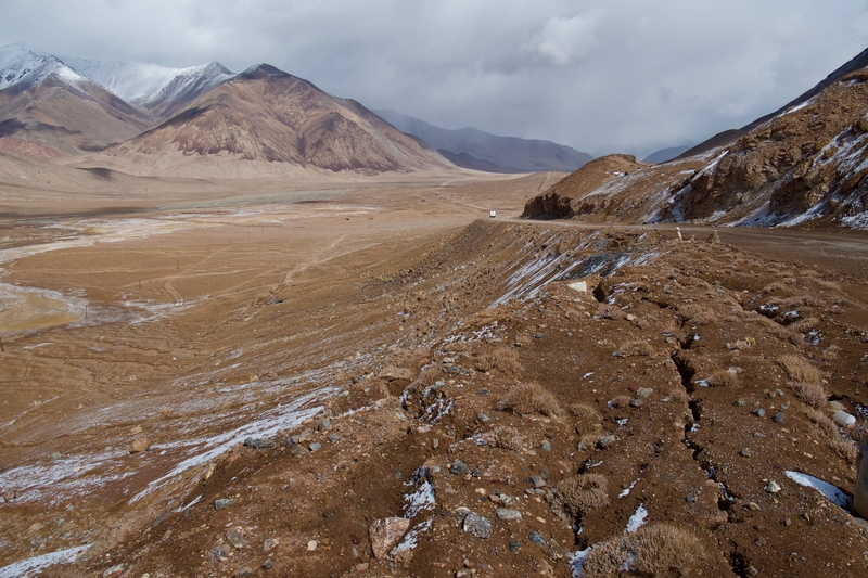
Pamir Highway Road Trip Itinerary
Last modified on February 12th, 2021 at 11:29
The Pamir Highway is a high-altitude road that bypasses some of the most dramatic mountain scenery in Central Asia. Traversing the Roof of the World, this spectacular ribbon of pavement winds between craggy peaks, past glistening lakes and through lunar landscapes.
F ormally known as the M-41, the Pamir Highway extends from Osh in Kyrgyzstan to Mazar-i-Sharif in Afghanistan. Driving along the Pamir Highway is an ultimate road trip adventure for lovers of culture and off-the-beaten path wilderness.
Table of Contents
PAMIR HIGHWAY: PLANNING AND LOGISTICS
After two weeks in Kyrgyzstan and southern Kazakhstan , I flew from Bishkek to Osh in order to begin my Pamir Highway road trip. By this point in my travels to Central Asia, Dan and Courtney had both returned to the United States. As a result, I found myself alone for the most adventurous leg of my month-long journey.
And what an adventure it was.

Traveling the Pamirs is not easy.
Roads–even along the main thoroughfare–are in in terrible shape. Homestays are rudimentary. Hygiene standards are foreign concepts. And even for those who think they’ve penned down their perfect route, altitude sickness, landslides and severe weather can turn carefully-planned itineraries upside down.
HOW TO TRAVEL THE PAMIRS
There are several ways to travel the Pamir Highway. Some budget travelers choose to hitchhike or rely on limited public transport between larger towns. Others choose to cycle the high altitude road in a show of mental fortitude and physical strength.
Most, however choose to hire a driver to take them from Osh to Khorog on a road trip varying between four and ten days.

Knowing I wanted to hire a vehicle for the route, I began scouring forums and reading travel blogs in preparation for my trip. With the help of the Internet, I found three other people—a Dutch/Polish couple and a solo Malay traveler—with whom to share the journey. We met at the Osh Guesthouse and finalized logistics.
Two days later, with a jeep full of newfound friends, a bag full of layered clothing, a head full of apprehension and heart yearning for adventure, I set out into the unknown.
We organized a five day tour with Visit Alay –a company that focuses on travel to southern Kyrgyzstan and Tajikistan.
PAMIR HIGHWAY TRAVEL COSTS
The cost of traveling along the Pamir Highway varies depending on number of people, length of time and total kilometers traveled. Between the four of us, we payed $225 per person for five days. The price included transportation, as well as meals and lodging for our driver. It excluded our own meals and accommodation, which usually ranged between $15-20 extra per day.
VISAS AND PERMITS FOR THE PAMIR ROAD TRIP
Traveling the Pamirs requires a bit of advanced planning. As an American, I needed to organize a Tajikistan e-visa and GBAO Permit before crossing the border between Kyrgyzstan and Tajikistan.

The GBAO Permit is a document that allows for travel through Tajikistan’s Gorno Badakhshan Autonomous Province. Both the visa and permit can be easily obtained online in a couple days.
PAMIR HIGHWAY: ROUTE AND ITINERARY
Our five day Pamir Highway itinerary brought us from Osh to Khorog via the Wakhan Valley. From Khorog, we hired a 4X4 shared taxi to take us the remaining 600km to Dushanbe–Tajikistan’s capital city.
Over the course of five days, we ogled at the snow-capped Peak Lenin, meandered through yak-studded pastures and peered into Afghanistan’s Wakhan Corridor.
DAY 1: OSH TO PEAK LENIN BASE CAMP
The first leg of our journey brought us to the Alay Region of southern Kyrgyzstan. Home to undulating golden landscapes and soaring mountain peaks, this spectacular area of the country cemented my love for Kyrgyzstan as a trekking destination.
From Osh, we joined the M-41 and began our steady climb into the Pamirs. As we drove higher and higher toward the Roof of the World, the scenery grew more breathtaking by the minute.
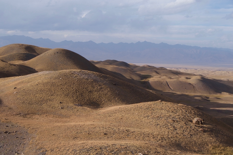
Along the way, we watched daily life unfold. We passed by red rock canyons, winding mountain passes and tiny villages where time seems to have stood still. There were few other vehicles traveling the Pamir Highway. Most roadblocks we encountered consisted of herders leading their cows and sheep to water.
On our first night along the Pamir Highway, we stayed in yurts at the Peak Lenin Base Camp near Sary Mogul. The yurt camp sits along the shores of Turparkol Lake, nestled among rolling hills of golden grass.
We arrived at Peak Lenin with time to settle into our yurts, enjoy a short walk along the lake, and soak in the surrounding views.
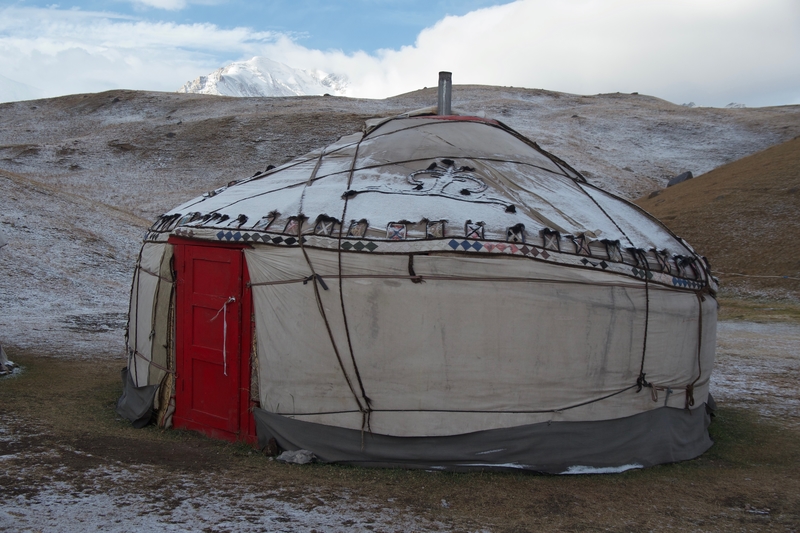
The camp’s lakeside setting is magical in all directions. Treeless golden hills undulate under the vast sky, spanning out in all directions. To the north, a ring of purple mountains linger on the horizon. To the south, Peak Lenin’s towering massif looms overhead.
DAY 2: PEAK LENIN TO KARAKUL
On the second morning of our Pamir Highway tour, we woke up to a layer of snow blanketing the surrounding mountains. Our Pamir Highway itinerary afforded us a bit of time to explore the area prior to hitting the road, so I set off into Peak Lenin’s wilderness for a few hours.
From the yurt camp, a trail leads toward Traveler’s Pass. At every step of the way, gold-gilded mountains and snow-capped peaks took my breath away. I had difficulty putting my camera down.
Unfortunately, I didn’t have time to complete the trail before leaving. A combination of lack of time and breathlessness from the altitude forced me to turn back after a few kilometers. The vistas I saw, however, were some of the most extraordinary of the entire trip.
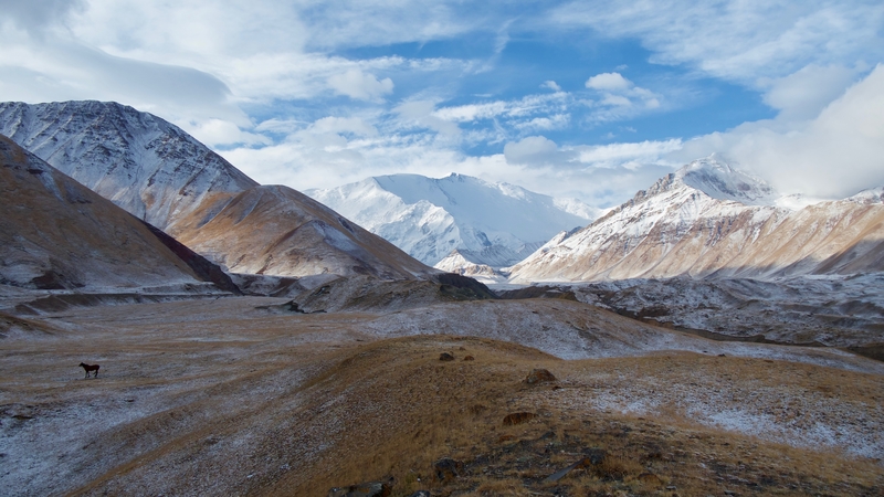
Upon leaving Peak Lenin, we continued skyward, toward the Tajikistan border. As we climbed in elevation, the golden grasses of Kyrgyzstan gave way to Tajikistan’s lunar landscapes. For the next few days, I felt as though I was cruising along the surface of the moon.
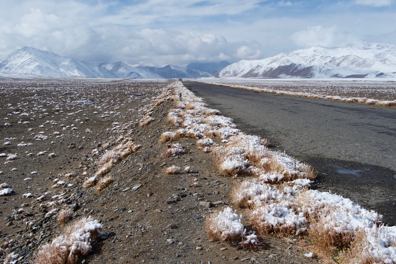
A few hours after crossing the Tajikistan border, we arrived in Karakul–an expansive mountain-ringed lake situated within an impact crater. The mud-brick village of Karakul lies along the shores of the lake. The town is small and eerily quiet. Though we were visiting in late summer, temperatures were near freezing and we could see smoke rising from the chimneys of the mud-walled houses.
My companions and I bundled in our warmest clothes, meandered through the village and walked to the shores of the lake. When our fingers and faces stung from the cold, we retired to our cozy homestay for dinner and a cup of warm tea.
DAY 3: KARAKUL TO ALICHUR
The following morning, we left Karakul and sailed past scree-covered valleys, toward Murghab. Though it was summer, harsh winds bit at my face. Snowflakes danced about, slowly covering the ground in a thin layer of white.
The third day of our Pamir Highway road trip brought us to the highest point on our journey–the 4655 meter Akbaital Pass. We crossed the pass and admired the sweeping views of the barren valley, careful to avoid physical exertion at every cost. The altitude was not only visible, it was also tangible. As we soared higher and higher into the Tajik Mountains, we could feel the air grow thinner. Our breaths accelerated in rapid succession. When we ran out of the car for a bathroom breaks, we would often find ourselves gasping for air.
After crossing the pass, we descended to the village of Murghab for a lunch break. Our driver–a friendly Tajik from Murghab–invited us to his home for lunch and a chance to meet his family.
For a few hours, we interacted with our driver’s hospitable wife and kids. Then, giving him a little privacy with his family, we set out to explore Murghab’s shipping container market before continuing to our homestay in Alichur.
Murghab sits at a cross-roads. Positioned between China and Afghanistan, this makeshift town was a 1895 Soviet military outpost that signified the farthest reaches of the Soviet Empire. Seemingly at the edge of civilization, it has a temporary frontier feel.
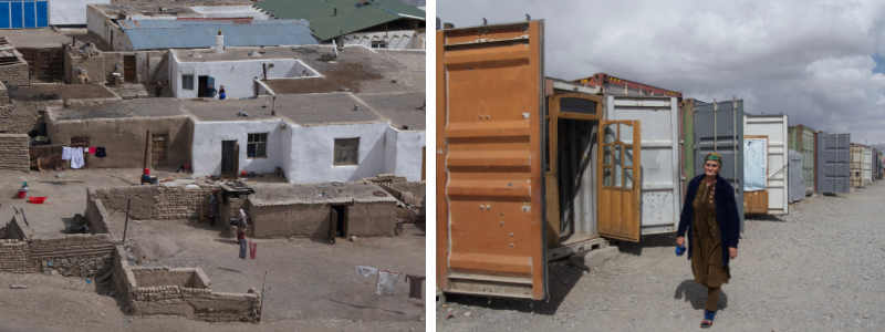
The landscape surrounding Murghab is bleak, with not a tree or shrub in sight. In all directions, the scenery is empty. Eerie. Desolate.
The Pamiri women of Murghab wear scarves wrapped around their entire heads–revealing only a small slit for the eyes–to shield against the wind and dust. As we walked around town, the wind bit at my face. It was not even Autumn yet, and still we had to battle the elements.
I could only begin to imagine the harsh reality of life in the Pamirs.
DAY 4: ALICHUR TO LANGAR
The fourth day of our Pamir Highway tour consisted of vast glassy lakes, wide open skies and yak-studded pastures. We covered a relatively short stretch of road during the fourth day of our road trip. In this section, we took short hikes around glistening lakes and frequently got out of the car to stretch our legs.
Lakes Bulunkul and Yasilkul lie a few kilometers off of the M-41. We took the detour toward the lakes and were asked to pay a small fee before reaching the Yasilkul lookout. The fee (paid to a local man from a small village near the road turnoff), seemed like a ploy to make a couple dollars off of tourists.
Regardless, I happily handed over two dollars in exchange for views over the lake’s sky-blue waters. In the high altitude lunar landscapes of the Pamirs, the lakes look like mirages–their placid surfaces reflecting the massive skies overhead.
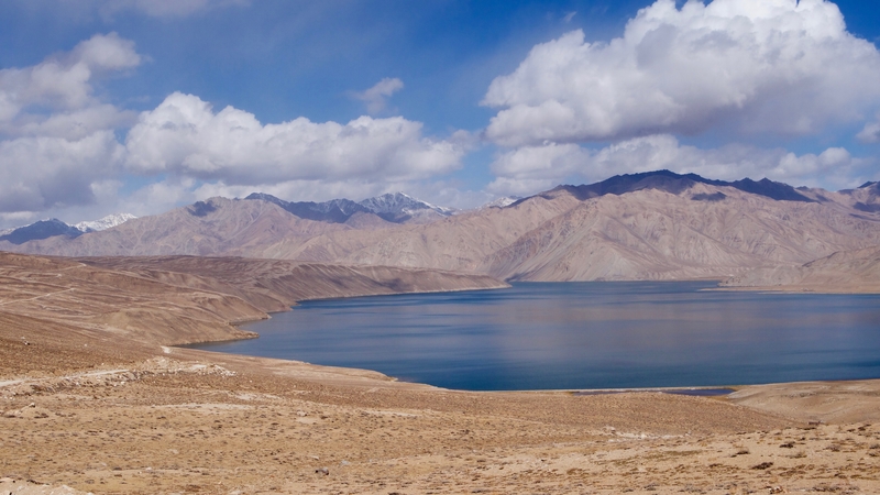
From the chain of lakes, we continued toward the Afghan border.
There, we handed over our documents at a checkpoint, turned onto a particularly bumpy stretch of road and caught our first glimpses of Afghanistan from across the river.
DAY 5: LANGAR TO KHOROG VIA THE WAKHAN CORRIDOR
The Wakhan Valley is a popular detour from the M-41. The bumpy gravel road follows the Panj river as it winds between some of Central Asia’s tallest peaks.
The entire corridor on either side of the river is speckled with mud-walled villages that are nestled in fertile plots of cultivated land. Unlike the lunar landscapes we had encountered on days 2-4 of our Pamir Highway tour, the Wakhan Valley is home to trees and patches of green earth. Beyond these fertile slivers of green, towering valley walls give way to glimpses of the Hindu Kush mountains.
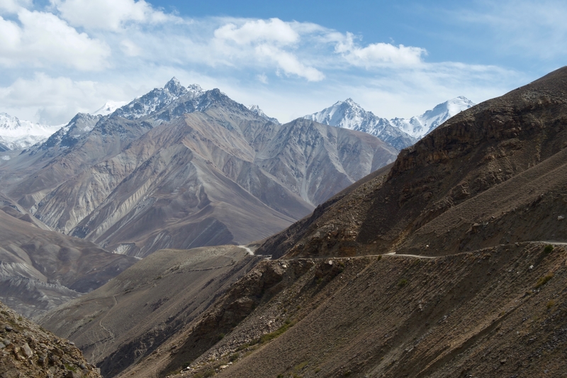
Small human settlements lie along the river, strung together by patches of arable land. Among these villages, ruins of caravanserais and forts stand as a testament to the area’s storied past.
The main highlight along the Wakhan Corridor the Yamchun Fortress–a stone structure that dates back to the 3rd century BC and overlooks fertile lands on either side of the Panj.
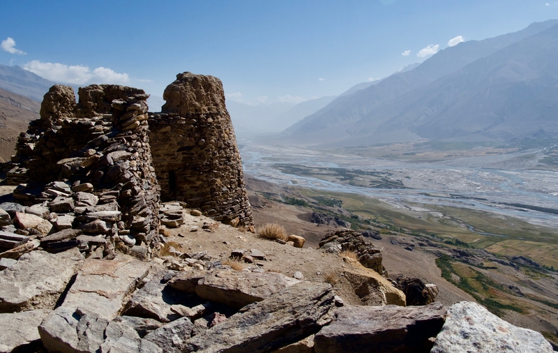
Apart from the beauty of the journey, the Wakhan Corridor’s proximity to Afghanistan makes it a fascinating detour from the M-41.
Villages along the Wakhan Corridor look as though they’ve remained untouched for centuries. I was so close to Afghanistan, that I could practically touch its soil with my outstretched arms. Across, the river, I waved at Afghan caravans leading their herds to the water. I watched women wash their clothes along the riverbanks. I glimpsed children running about, playing as though they had not a care in the world.
It was an eye-opening window into a forbidden and hauntingly beautiful country. A country that I one day hope is safe enough to explore.
A road trip along the Pamir Highway is not for the inexperienced traveler. For those accustomed to luxuries on the road, the Pamir Highway can be a challenge. There is little variety in the food, accommodation is rudimentary at best, and toilet facilities are among the most revolting I’ve ever come across.
But travelers willing to step outside of their comfort zones, will find that there are few adventures more rewarding than a road trip along the Roof of the World.
Like this Pamir Highway Road Trip Guide? Pin it!

- Skip to primary navigation
- Skip to main content
- Skip to primary sidebar
- Black Travel
- Destinations
- Travel Resources
Pamir Highway travel guide
20/03/2021 by Roobens 9 Comments
Some links are affiliate links, which means if you make a purchase through these links, I earn a commission, at no extra cost to you.
The legendary Pamir Highway, also called M41 Highway! That name might not ring a bell, because it’s not that famous among the general public, but all those who traveled in Central Asia know at least the name “Pamir Highway”, and all those who go to Tajikistan are basically going there for the Pamir Highway (or the Kulikalon lakes hike ). Anyway, what’s so special about the M41 highway? Read this Pamir Highway travel guide to find out!

Table of Contents
What is the Pamir Highway?
That route starts at Osh (south of Kyrgyzstan ), and goes all the way to Mazari Sharif (Afghanistan), passing by Tajikistan. Beyond the length of the Pamir Highway (2000 kilometers/1250 miles), the incredible landscapes you pass by while riding through that road is what attracts all the visitors here. On a portion of the road, 30 meters only (100 ft.) separate Tajikistan from Afghanistan. Indeed, the Pamir Highway goes along the border with Afghanistan, and the two countries are separated by a small river (the Panj river). I’m first gonna talk about my road trip on the Pamir Highway, then, I’ll give you all the useful tips if you wanna do it too! By the way, if you’re into road trips, check out these quotes about road trips !

Road trip on the Pamir Highway
But let’s start from the top. Almost all travelers decide to ride from Osh in Kyrgyzstan, to Dushanbe, the capital of Tajikistan, with several stops in different villages on the road to sleep. Actually, the best and most interesting portion of the road goes from Osh to Khorog. By the way, like most people, I did Osh-Dushanbe but you can also do it the other way around, from Dushanbe to Osh.

After leaving Osh in the 4×4 we rented for a few days, the first step seemed pretty simple : ride all the way to the Tajik border, and cross it! We left Osh at 8:45am, and we arrived at Sary Tash, the border town with Tajikistan, around noon. That little town, for your information, is at an altitude of 4282 meters (14000ft)! The first thing the miliary men said when they reached our car “ No pictures here!!! ” Actually they told us not to take pictures at least four times. Then they thoroughly searched through our bags, inspected our passports… I’m used to it now! Since it was noon, most customs officers were having lunch. The few ones who were there asked us to wait. One of the customs officers was watching something inside the car, I could see him becoming agitated, but from his look nothing threatening.

Oh I finally got it. He was watching me , he was actually staring at me with that look of amusement on his face and he decided to call his colleagues via walkie-talkie. His buddies came out of a building behind us, big, tall and strong military men. They greeted me in a friendly way, they laughed and then they asked for pictures . I said “ No “. “ Huh??? Why not? “. Thinking about it, it was quite audacious, talking like this to those guys. I’m depending on them to get in the country, I was at their mercy, I could have stayed there, stuck in the middle of nowhere!

“ Why? Why don’t you want to take a picture with us? ” “ I’m just obeying your orders, you said no pictures in the area “. They burst out laughing “ Hahahaha! All right we’ll make an exception just for you haha! ” I took advantage of the opportunity to ask for a picture, too! “ No “, in a firm and serious tone. Friendly ok, but they kept it professional. All right, no souvenir for me…

Kyrgyzstan / Tajikistan border
Crossing the border took like three hours. Waiting for the customs officers who were having lunch, the long time we waited while they were searching through our bags, the paperwork, the pictures with me… Oh and there’s a 25 kilometers (15 miles) section of no-man’s land separating Kyrgyzstan from Tajikistan. We stopped four times, at various checkpoints, and every time our driver paid the military men a bribe. Seriously, he gave money to all of them. I think the bribe was included in the price we (tourists) paid for this trip…

Once we crossed the border, the Pamir Highway was deserted. No one. We rode on the highway for like three hours, and seriously, we didn’t pass a single car! In three hours! We saw two or three stray dogs (I wonder how they got there…), but otherwise not a single soul. Oh actually we passed by a small village, Karakul, where you’ll see a wonderful lake. I got it. We were at an altitude of 4000 meters (13000 ft.), it was cooold up there and the road was unpaved most of the time. We reached a peak altitude of 4655 meters (15000ft)! We finally passed a group of cyclists. Pedalling like this, knowing it’s freezing and the road is in shitty conditions, respect!

Our first stop will be in the city of Murghab. Let’s face it, it’s a small town where there’s not much to do. A market, a mosque, and that’s it! And forget about your social media. There’s no internet in the hotel you’re probably going to stay at, the Pamir hotel. As the manager said “ No Wi-Fi, no problems! “. Since there’s no internet, take advantage of the opportunity to talk and interact with the locals. Everytime I told them “ I’m from France “, they didn’t believe me. “ Where are you really from ? Africa? America? But not France! “

As I said earlier, the Pamir Highway is at high altitude (Murghab is at 3600 meters/12000 ft), you get tired faster since there’s less oxygen. Two of the people I was with had headaches, they were even dizzy at times. Take all the necessary precautions before going there, and do not go there without a travel insurance ! I had a little headache but nothing more, my body was now used to high altitude after spending a few days horse riding along Song Kul in Kyrgyzstan, at an altitude of 3400 meters/11000 ft.

The day after, we hit the road quite early in the morning. Once again, the landscapes were breathtaking and the ride was enjoyable, even though the road on the Pamir Highway is not in good condition. The driver made us listen to some traditional Tajik music. He recorded it on his cassettes (a cassette player in a car, I haven’t seen those in a looooong ass time!).

Langar / Bibi Fatima
We kept riding, and we kept passing by villages in our 4×4! People stared at us, trying to see who’s inside the car. We passed by Langar, and we stopped at Bibi Fatima, at an altitude of 3100 meters (10000 ft.). This is where you’ll find the famous Bibi Fatima Hot Springs ! The entrance fee is 10 somoni (one euro) for foreigners, and men and women are given separate pools to bathe in.

As soon as I got in the water, I realized I was the only one with a swimsuit. “ Get it off!!!” kept telling the few guys there. Yep, we’re all naked in there. I was ill at ease, the young locals kept staring at me and apparently, they were taking great care of every single part of their body, which is definitely not the priority of a backpacker, if you know what I mean…

In the same area, you’ll also see a 2200-year-old fortress . This fortress is in the heights of Bibi Fatima, and is in ruins but from there you get to see astonishing landscapes of Afghanistan, just in front of you. One hour is enough, just climb around to enjoy the view, take some pictures, relax in this peaceful atmosphere, and then you can go!

While I was in Bibi Fatima, I noticed that I hadn’t seen men and women walking together in the street. Every time, groups of men, groups of women, but no mixing. Bibi Fatima was also the village where I interacted the most with the locals. It was easier, in this area, people greet each other in the street. And I also tried to chat a little bit when they were asking to get a picture with me.

Anyway, the locals told me that there are four languages in the country : Tajik (normal!), Russian (like anywhere else in Central Asia!), but also Wakhan (specifically spoken in this area, Wakhan Corridor, located in the south of the country and northeast of Afghanistan), and Khorog (spoken in Khorog only). Tajik people have their faces marked with deep wrinkles quite young. They look like Persian people ( Iran ), a little bit like Asian people but not like Russian people.

Further on the Pamir Highway, we stopped at Ishkashim, exactly at the Ishakshim fort. We were riding along the border with Afghanistan. From the fort, we could very distinctly see Afghanistan, which is just a few dozens meters in front of us. And Pakistan is like 30 kilometers away (20 miles). Sentries were hiding in the fort, and they were watching the river, just in case a reckless idiot tries to cross the river by swimming.

We finally made it to Khorog, a big city. It means this is the end of our road trip! I met a lot of travelers there. Khorog is what I call a city where you just rest. You see people who just finished their trip on the Pamir Highway, and others who are about to start. A lot of cyclists, too, having a break there for a few days. Since there are many tourists, people speak good English in Khorog. Even better than the neighbouring countries in “Stan”. Just walk around in the city, watch their daily routine… And enjoy a good meal there! Either at Varqa, delicious Tajik restaurant, or Delhi Darbar, very popular Indian restaurant. You can go there by marshrutka (mini van), the ticket costs 1.5 somoni (0.15€…). If there are no more marshrutkas because it’s too late (it happened to us), ask the locals if they can pick you up and drop you where you want to. They’ll do it with pleasure, and won’t ask for any money 🙂

One thing you definitely cannot miss in Khorog : the Saturday morning Afghan market. It’s the only opportunity to interact with Afghan people without going to Afghanistan. Unfortunately, the market is not open every Saturday. Sometimes it’s there, sometimes it’s not, and there’s no annoucement beforehand. They make the decision at the very last minute, which means the same day very early in the morning! I went there on a Saturday but it was closed “ Sorry, no Afghan market today ” 🙁

From Khorog, you’ll have to go to Dushanbe, the capital. It’s a 12-13 hours ride, once again along the border of Afghanistan. On the other side of the river, we could see little kids playing, women doing laundry. We were waving at them, and they always waved back us, with big smiles.

As I said, the road on the Pamir Highway is definitely not in a good condition (unpaved, rocks on the road here and there…), and our driver was driving way too fast. Because of his driving, one rock burst the car’s right tyres. And we only had one spare wheel… In less than 10 minutes, six cars and one truck spontaneously stopped, asking if we needed some help. Nice!

Dushanbe was the last stop. Not much to do there, no need to stay for a long time, three days are more than enough. There’s a market, some beautiful green spaces and parks, and many portraits of the president, Emomali Rahmon . Going to Uzbekistan next? Here’s how to get to from Dushanbe to Samarkand . At the Dushanbe airport, as I was about to take a flight to go to New Delhi , I forgot I had a full bottle of water in my bag, but apparently they didn’t care, I made my way through the security and they didn’t say anything. Before that, a security guy (the one searching through your bag) started talking to me “ You’re from Paris? I looove France, blablabla… ” I saw him coming… Then he asked “ Do you have money? Where is it? Show me your wallet! Dollars or somoni? ” And then “ Give me some money please, for a coffee “. He didn’t get anything from me, but I guessed it was time for me to leave Central Asia, and to explore another part of the world…

Visa policy of Tajikistan
First thing first, you need to go to Tajikistan! Check the visa policy here ! Unless you’re from Azerbaijan , Armenia , Belarus, Georgia , Kazakhstan , Kyrgyzstan , Moldova , Russia or Ukraine , you’ll need a visa to get there. Nothing complicated, you don’t need to go to an embassy, just apply online here ! You’ll have to pay 50 US dollars. During the process, they’ll ask you if you want a GBAO permit, which allows you to go to the territory of Badakshan. The Pamir Highway being on that territory, you’ll have to ask for that GBAO permit, and pay an additional 20 US dollars. That means the Tajikistan visa will cost you 70 US dollars. Before getting there, click here to check the latest flight prices.
How to travel the Pamir Highway
You’ll probably start from Osh in Kyrgyzstan or the other way around from Dushanbe, the capital. In both cases, to travel the Pamir Highway, you can travel either by public transport (not recommended, sometimes you’ll wait for hours in some villages, waiting for the marshrutka to be full before leaving), hitchhiking (doable, but most cars passing by are already full, you’ll have to be patient), with your own car if you have one, cycling (all the cyclists I met in Khorog said it was one of the best experiences they ever had), with a travel agency (the most expensive!) or the more convenient, rent a 4×4 with driver. That’s what I did.
If you go to the Pamir Highway from Osh, check the Kyrgyzstan visa policy here. But you probably don’t need a visa 🙂
How much is the Pamir Highway trip
If you decide to rent a 4×4, the best thing to do is to travel with a full car, to split the costs. Ask your hotel/hostel if anyone plans to travel the Pamir Highway. I don’t know for Dushanbe, but in Osh you’ll find easily. We were five, and we paid 700 US dollars total (140 US dollars each) for 5 days/4 nights. The price included the car, the driver, and the ride from Osh to Khorog. The price didn’t include the meals, accommodation in the different villages and the ride from Khorog to Dushanbe. For a one-week trip, you’ll pay about $1000 for 5 people.
If you wanna try traveling the Pamir Highway by public transport, it will obviously be a lot cheaper. Same if you decide to hitchhike. If you travel the Pamir Highway by bicycle, you obviously won’t pay that much, and from what I heard, the experience is incredible. If you want to rent your own car, you have an idea of the rates here . But FYI, it’s really hard to drive there, the road is sometimes in very bad condition! If you travel the Pamir Highway via an agency, it will be more expensive and you’ll get the exact same experience…
Where to find people to travel the Pamir Highway
If you go to the Pamir Highway from Osh, you can stay at the Osh Guesthouse . This is where I stayed, and this is where most backpackers go. There’s a big board with useful information : available cars, next departure dates, number of people per car. Thanks to this board, I found out the next car was leaving two days later, and they needed one more person to “fill” the car. The staff at the Osh Guesthouse is very friendly, however the guesthouse is not very clean… Otherwise, you can stay at another place (check Booking ), but go to Osh Guesthouse just to check the next departures, the cars available…
Accommodation on the Pamir Highway
Regarding accommodation, you’ll see by yourself, it’s quite expensive for what you get. 10 US dollars per night at Murghab with no internet and power cuts, 15 US dollars per night at Bibi Fatima with no shower and of course no internet (we had to go to the hot springs to have a wash, 10 minutes away!).
However, in Khorog, you should definitely stay at the Pamir Lodge. This is where you’ll find all the travelers starting or finishing their Pamir Highway trip! In Dushanbe, everyone stays at the Green House Hostel. Click here to book your stay . If you’re not into backpackers hostels, there’s also the Hello Dushanbe. Click here to book your stay .
Food on the Pamir Highway
You’ll have to pay for the meals but it’s cheap. We never paid more than 15 somoni (1.50€) for a meal with tea. Actually it was more about 10 somoni (one euro).
Internet on the Pamir Highway
Not only on the Pamir Highway, but also in the whole country (Dushanbe might be the exception), internet is reaaally slow… I really needed the internet, so I took a local SIM card. The SIM card costs 35 somoni (3.50€) with 1GB, 58 somoni (5.80€) with 2GB. I didn’t get it to waste my time on Facebook or Instagram, but with a local SIM card, you can use your phone as a modem (tethering & portable hotspot), and work on the blog so that you guys can read me 😀
While we’re at it, don’t forget to use a VPN. I use ExpressVPN , fast and efficient. Here’s why you should use a VPN when traveling .
When to travel the Pamir Highway
The best time to travel the Pamir Highway? From April to October. Actually from June to September. From November to March it’s freezing.
How long is the Pamir Highway road trip
We did Osh-Khorog in five days, but many people told us it’s a bit too fast. If you have time (and if that doesn’t bother you being cut off from the rest of the world), one week, or even ten days, it’s better! People usually do a one-week trip.
Pamir Highway travel tips
- Traveling soon? Check out my travel resources page! This list of travel accessories can also be useful!
- Do not go to Tajikistan without a travel insurance ! The Pamir Highway is at high altitude, many people feel faint. Better safe than sorry! Here’s why you should buy travel insurance !
- Want a tailor-made trip to Tajikistan? Get a free quote here !
- Regarding Khorog-Dushanbe, we paid 250 somoni (25 euros).
- I did Khorog-Dushanbe in one day, but of course you can do it in two days. A lot of travelers spend a night in Kalai Khum, a small village between the two cities.
- In Khorog only (and its area), the time zone is different than in the rest of the country (one hour ahead of time!). It can be confusing at first…
- Dushanbe means “Monday”! This is Persian, it literally means “the second day of the week”, which starts on Sundays.
- In Kyrgyzstan, they have 3 soms coins. In Tajikistan, they have 3 somoni bills! Someone needs to explain me their logic…
Sign up for exclusive updates in your e-mail address!
Related Posts

Reader Interactions
20/12/2017 at 15:46
Wow1 I would have never guessed that Tajikistan is a great road trip destination, Roobens! Thanks for the motivating and intriguing post. How long did your road trip last?
21/12/2017 at 10:45
Hey Agness! As I said on the article, it was a 5-days trip.
22/12/2017 at 19:33
You’re landscape pictures are great! Makes me want to travel there right away – thank you for sharing your road trip adventure!
23/12/2017 at 04:05
Thank you! Central Asia is overlooked, you should go 🙂
15/12/2018 at 17:37
Was it safe to drink from tap water on the way in Pamirs?
15/12/2018 at 17:38
What about the Afghan market in Ishkoshim? Open?
17/12/2018 at 13:25
No it’s not safe to drink tap water in the Pamir Highway. As for the Afghan market in Ishkoshim, I can’t tell since I didn’t go.
18/12/2018 at 13:50
Such an inspiring road trip! We are thinking to do something similar with my wife next year. You gave a lot of useful tips, I will definitely save this article for the future. From all your list I have just Nordvpn subscription, but I guess in these days if I have an internet connection and a trustful vpn, then there is nothing to worry about.
18/12/2018 at 17:01
Thank you!!! Yeah as long as you use a VPN, there’s nothing to worry about 🙂
Leave a Reply Cancel reply
Your email address will not be published. Required fields are marked *
Don't subscribe All new comments Replies to my comments Notify me of followup comments via e-mail. You can also subscribe without commenting.
This site uses Akismet to reduce spam. Learn how your comment data is processed .
- Skip to primary navigation
- Skip to main content
- Skip to footer
Caravanistan
The Silk Road Travel Guide
Pamir Highway
The Pamir Highway. It’s a name that vibrates strongly in the belly of anyone with a taste for adventure.
The high desert of the Pamir invites expletives and superlatives. Like the Altiplano and the Tibetan plateau, this is a harsh and lonely place, inhabited by kind people. Its unforgiving landscape breathes tranquil spirituality. These are mansions of the lonely spirit.
The M41 is the second-highest highway in the world, after the nearby Karakorum Highway. It crosses the whole Pamir region of Tajikistan, running from Osh to Khorog to Dushanbe . From this road, you can look at China, peek into Pakistan and wave to villagers in Afghanistan.

1250 kilometers of spectacular landscapes, left and right, above and below. Plenty of side trips too, to meet hospitable locals, go on outdoor expeditions, spot wildlife or camp all alone on the edge of a lake.
Take your time to ride the Pamir Highway. The Pamirs are remote, a challenging destination for body, mind and soul. To those willing to delve beneath the surface of tourism-related travel, an interesting, living culture will bare itself. Traces of history that go back to the Bronze Age, pristine lakes and rivers… some of the highest mountains in the world.
Far away from everything, it’s more connected than it looks. The questions of the day, like global warming, economic migration, Chinese imperialism and the interpretation of Islam, resonate stronger here than they do at home. You can experience the impact first-hand, instead of through a medium. Stay a bit longer, and you will feel right at home.

Table of Contents
GBAO permit and checkpoints
To travel on the Pamir Highway, you will need a GBAO permit , and a Tajik visa . The GBAO permit is checked at various checkpoints along the road. Individual travelers have had trouble in the past with corrupt border guards at some of these checkpoints, so do have a read through the article on Pamir Highway checkpoints to know what to expect.
Route planning
This article only deals with destinations on the Pamir Highway. For more information about destinations off the Highway in the Pamirs, see our Pamir travel guide .
Overview of the route

Osh to Murghab
Osh , the capital of southern Kyrgyzstan, and Dushanbe , the capital of Tajikistan, are the start and end points of the Pamir Highway. They are both located on a low-altitude plain, searing hot in summer. From these 2 starting points, the road quickly climbs to high altitude, and the temperature drops.
From Osh, the road leads east towards Xinjiang . A steep climb into the Pamir-Alay is accompanied by stunning landscapes all the way. At the hamlet of Sary Tash , you can continue east to reach the Irkeshtam Pass and Kashgar .

Instead, the Pamir Highway turns south to the 4280m Kyzylart Pass, where the Kyrgyz-Tajik border crossing lies. The first town past the border is Karakul , on the shores of a meteoric lake by the same name. Cycling adventurers can shortcut into the Bartang valley not far from here.
Push over the Ak Baital Pass, at 4655m the highest point of the Pamir Highway, to roll into Murghab . Both Karakul and Murghab are rather depressing and uneventful, but they make a good base for eco-cultural tourism in the neighbourhood. There’s more to see and do than you would initially imagine. With your own transport, untamed frontiers await in all directions.
East of Murghab lies the Qolma Pass that directly connects the Pamir Highway to the Karakorum Highway . You know you want to.

Murghab to Khorog
From Murghab, the road continues into the wild and empty moonscape of the Alichur plain until Khorog . Interesting little side trips lead to Rang Kul, the ancient silver mine of Bazardara, or the Shakhty caves .
Past windy Alichur , most people prefer to head over the Khargush pass to take the Wakhan valley detour, instead of heading straight to Khorog. With majestic scenery, lots of village life and a chance to glance at Afghanistan’s Wakhan Corridor , it is one of the most captivating bits of the whole Pamir Highway.

If you take the northern route instead, you move through the Ghunt valley , the start of many treks, for instance to Lake Sarez . Just before the turn-off to the Wakhan lies the village of Bulunkul with crystal-clear Lake Bulunkul and Yashilkul. If you continue straight you come to the hot springs at Jelondy.
There is also an oft-overlooked middle route, with a turn-off 40 km past the start of the Wakhan valley. The Shakhdara valley also has interesting relics, hot springs, villages et cetera + iconic vistas of Peak Engels and Peak Karl Marx. Makes a nice loop in combination with the Wakhan, but the road is very bad. The 3 routes converge in Khorog.
Khorog to Dushanbe
Khorog is the capital of the Pamirs. That doesn’t mean much, but it’s a good base to plan the rest of your journey if you haven’t done so yet. The surrounding area also abounds in fire temples, holy springs, fortresses, shrines and petroglyphs.
Continuing from Khorog, the Pamir Highway passes the Bartang and Vanch valleys, splendid destinations in their own right with a number of attractive villages each. At Qalai-Khumb , the road splits into 3 options to get to Dushanbe.

The northern road crosses the Tavildara Pass before heading into the Rasht valley , where the Jafr botanical gardens are. It is a bit shorter, but it is poorly maintained and closes in winter ( updates here ). It’s the adventurous route.
The southern route goes into Khatlon via Kulob and has a better driving surface. The lowlands between Kulob and Danghara are not visually stimulating, but since 2021, a new highway offers a pleasant detour going Kulob > Muminobod > Childukhtaron > Khovaling > Baljuvon > Danghara.
It’s a lot of up and down, but traffic is almost non-existent, and nature is more interesting here, with pistachio forested hills, ancient trees and springs. A real 4WD adventure not for the faint of heart is the Yakhsu valley , that connects Khatlon to the Tavildara Pass.
For slow travelers, each has its attractions. If you are going fast, the southern route is quicker and easier on your car. A good stop about halfway (if you plan ahead and want to book a tour) is the Shuroabad conservancy where you can watch rare wildlife within a 2-day window.
If you prefer to go with the flow, Danghara and Kulob both offer opportunities for short stops.
Osh -> Dushanbe or Dushanbe -> Osh?
As you see fit. The whole route is quite spectacular both ways, but the stretches north of Murghab and the parts which trace the border with Afghanistan are the most exalted.
The main reason to doubt would be the steep ascent from Osh to Murghab . The altitude gain is more gradual coming from Dushanbe. Many travelers coming from Osh who ride to Murghab in one go end up suffering to some extent in Murghab or Karakul from the altitude.
For optimal acclimatisation, never sleep more than 400m higher than the night before once over 3000m. See the accommodation chapter for places to stay en route. See the altitude profiles for a better view.
For cyclists, the consensus is that you’re more likely to have tailwinds if you ride Dushanbe -> Khorog -> Osh. This is not a given, though.

Osh – Osh?
Another option you can consider if you don’t feel like going down to Dushanbe, is to go from Osh to Khorog and go back the same way. You will get to see the best of Tajikistan – twice! Past Alichur, you have the choice between taking the straight northern route on the M41, the Wakhan valley and the Shakhdara route.
On the way back, you can take the Bartang Valley, if the road is open. The Rasht Valley border crossing at Karamyk-Jirgital is still closed. If it re-opens, this would become a top route for the Pamir Highway.
Connecting with China
A rather new route is the crossing with China at Qolma , near Murghab. In China, the first town is Tashkurgan, from where you can head north to Kashgar, or south to Pakistan.
Instead of Dushanbe – Osh you would go Dushanbe – Tashkurgan. Instead of Osh – Khorog – Osh, you would go Osh – Khorog – Tashkurgan. An interesting option.
How much time do I need?
You can cover Dushanbe-Osh in 4 days by car, driving around 8-9 hours a day. To take in the Wakhan Valley, you need to add an extra day. If you are ok with a 16-hour drive, you can even do it in 3 days. Obviously, you will not do much in that time except for sitting in the car.
You also don’t have any leeway in case something happens, like a landslide, a flood or an avalanche, and the road is blocked.

If you would like to see some of the sights, enjoy the scenery and talk to the people, budget at least a week. Those on public transport should budget a few days extra to account for waiting times and unexpected pit stops.
If you are serious about enjoying and discovering the Pamirs, 30 days will give you the time to do a serious hike, visit some side valleys, enjoy the local food and recover from the almost inevitable stomach bug.
Weather & when to go
Looking at the altitude profile of the Pamir plateau, it’s clear that you should bring some warm clothes at any time of the year. Nonetheless, dry, warm and stable weather lasts from May to September in the valleys of the Pamir. Over 4000m, however, blizzards can occur any time of the year. Be prepared.
When looking at temperature charts, don’t forget to factor in the wind chill. Especially from Alichur to Murghab and Kyzylart, the wind can be fierce.
It’s cold. Temperatures stay far below zero, and people stay inside. This is the time for village weddings, when the men temporarily return home from work in Russia. Since there is nothing else to do, these are long drawn-out affairs.
Heavy snowfall is most likely later in winter. November and December are the driest months, February and March the wettest. There is much less traffic on the Pamir Highway in winter, but cars and trucks continue to drive, and the road is kept clear year-round.

The world awakens. Trekking at lower altitudes is perfect in spring, running from April until June. The village fruit orchards are in full blossom and the winter wheat is emerald green in the fields.
On the other hand, spring is the least rewarding time for high-altitude trekking in the Pamirs. High valleys and passes are still clogged with snow, the mountains are frequently cloud covered, and the risk of avalanches and rockfalls is at its highest.
July-August. While the rest of Tajikistan swelters in the heat, the Pamirs are pleasant. This is the time for mountaineering and high-altitude trekking. On the lower reaches, the sun might burn, but it never gets oppressively hot. But the vegetation has turned brown for a large part – it’s a bit less attractive.
September is the harvest month. It’s a short, delicious and colourful time, as the Indian summer sees poplar trees leaves turning a ravishing yellow. A sight for an impressionist painting, it’s the Pamiri version of sakura . Its ephemeral beauty heralds a new winter. By and large, when October comes, the travel season is about to finish.

Road conditions
The majority of the Pamir Highway is paved. Do expect potholes, and many twists and turns. An average speed of 40-50km/h is reasonable.
- Osh to Sary Tash: perfect tarmac
- Sary Tash to the border: big potholes
- Kyzylart pass: 20 km of mud and gravel.
- Until Ak Baital pass: smooth but very undulating paved road. Few potholes
- Ak Baital pass: rough gravel with deep potholes, snow cover and muddy bits when it rains.
- Ak Baital – Murghab – Wakhan turnoff: good paved road. Few potholes.
- Wakhan valley: Mostly sand and gravel, with some scary cliffs where you dearly hope not to encounter a truck. The area around the Khargush pass is a hard slog for cyclists.
- Alichur – Khorog (direct): generally good tarmac, except the 20 km of the Koitezek pass, which is rough like Kyzylart and Ak Baital.
- Khorog to Dushanbe: very long, very bumpy ride until 20km past Qalai Khumb.
- The Tavildara pass is a very bad road. No tarmac, but it is open outside of winter. Cyclists and motorbikers with grit enjoy this ( updates here ).
- The southern road via Kulob is okay from Qalai Khumb to Kulob and very good once past Kulob.
Altitude profiles
We don’t have the perfect altitude profile yet, so we offer 2 versions: a Google Maps-generated profile, and another one registered on GPS from a motorbike (Murghab to Sary Tash is missing). GMaps has invented 2 scary peaks on either side of Qalai Khumb; it looks a lot smoother on the GPS-track.
Otherwise, I would judge the first profile more reflective of reality.

Driving times
- Dushanbe – Kulob: 3 h
- Kulob – Qalai Khumb: 6 h
- Dushanbe – Qalai Khumb via Tavildara: 9 h
- Qalai Khumb – Khorog: 8 h
- Khorog – Ishkashim: 3 h
- Ishkashim – Langar: 3 h
- Langar – Bulunkul: 6 h
- Alichur – Murghab: 2,5 h
- Alichur – Bulunkul: 1 h via M41, 2 h via geyser
- Murghab – Karakul: 2,5 h
- Karakul – Kyzylart border (TJ): 1 h
- Kyzylart – Bor Dobo (KG): 1 h
- Bor Dobo – Sary Tash: 45 min
- Sary Tash – Osh: 3 h
These are approximate times. Life in the Pamirs does not run to a Swiss clockwork, and a flat tire or an unexpected road stop can happen at any time.
Landslides and earthquakes do happen in Tajikistan as well, and they can disrupt traffic on the Pamir Highway for days. It does not happen every year, but there is always a chance that you get stuck while road workers are cleaning up the rubbish. So pencilling in a few extra days and coming up with a fun plan B is never a bad idea.
Other practicalities
Hygiene standards in the Pamirs are low. You can try to avoid diarrhea by washing all food, filtering water, relying on your own supplies and avoiding homestay meals. Pack appropriate medicine in any case.
Altitude sickness can happen to anyone staying over 2500 m (8200 ft) for more than 12 hours. As a general rule, you should not sleep more than 300-400 m higher than the night before to stay on the safe side. Diamox is a medicine that can help with acclimatising (talk to your doctor). For more questions, see the forum thread on altitude sickness on the Pamir Highway .
At altitude, UV rays are much stronger. Factor 45 sunscreen is recommended even if you don’t burn easily.
Finally, motion sickness is a huge problem on the Pamir Highway. Especially when using public transport, you can expect multiple vomit breaks. If you are prone, dimenhydrinate doesn’t exist in Central Asia, but dimedrol is widely available and works well enough, though it will leave you feeling quite stoned (worse than dimenhydrinate) so it’s not appropriate for all travel.
See our health in Central Asia article for all precautions to stay healthy in Tajikistan. We have also written about travel insurance for the Silk Road .

ATMs exist in Khorog, Qalaikhum and Vanch. We recommend not to rely on them because of the volatile situation in Tajikistan’s banking sector – they may very well be empty. Take as much money as you think you will need for the trip in US dollar. Exchanging is not a problem. Euros are not common – bring dollars.
If you are starting from Osh, exchange money before you leave. The rate is higher than what you would receive anywhere in Pamir. Currency exchange offices are gathered on Navoi street near the bazaar, just before the corner with Masalieva ( OSM ).
How much money will you need? That will depend on your type of transport and accommodation, and we have included estimates in the chapters below.
Our articles on money in Tajikistan and budget for Tajikistan have more info.
Communication
There is mobile reception almost everywhere along the Pamir Highway, although it can be weak in places. Megafon is currently considered as the company with the best coverage in the Pamirs. It’s possible to go online with mobile data.
In Murghab and Khorog, you can find wifi and computers with internet access. Be aware that electricity to recharge batteries is hard to find. A small solar panel ( Anker comes recommended) comes in handy.
Find more info in our article on phones and internet connectivity in Tajikistan .
There are 6 ways of traversing the Pamir Highway.
- Hitchhiking
Self-driving
- By public transport
- With a rental car
- Renting a car + driver
Or you could do like the Ukrainian couple we met in 2018, who bought a donkey and were doing it on foot.
Cycling the Pamir Highway
Cycling the Pamir Highway is no longer a frontier, with more bicycles than cars on the road in recent years. That does not make it any easier though. It is still a very tough ride.

Summarizing the key questions:
- The consensus is that you’re more likely to have tailwinds if you ride Khorog – Osh, but the views are better the other way. I don’t think it matters that much.
- Foodwise, you need to stock up on everything in Dushanbe, Khorog, Murghab, Karakul and Sary Tash. Shops have limited supplies of fruit and vegetables, only in September does it get better.
- In summer, lack of water is not a severe issue. The stretch from Alichur to Langar in Wakhan is the worst. The lakes are mostly salty there so take enough supplies before tackling this bit. Otherwise, fill up at every opportunity and definitely use a water filter.
- In terms of clothing: be prepared for all weather circumstances. A down jacket and gloves is never a bad idea. Strong winds mean good protection for your hands and face is essential; don’t forget sunscreen! And of course a good sleeping bag for the nights.
- There’s no need for MTB tires or wider trekking tires, neither would help in the sand, but both would slow you down a lot on everything else.
- Take spares and know how to use them. You are on your own.
- Do budget enough time. The altitude and bad road surface not only means you need to push harder. It also means you will have less oxygen. Most cyclists get sick, so factor in at least 1 toilet-day and 1 altitude headache-day to avoid rushing.
More general info is to be found at cycling in Tajikistan . Amongst the deluge of cycle blogs, the best report we have read so far is to be found at Pannier Journal .
Some of the best videos of the journey on a bike can be found here , here and here .
Bartang valley shortcut
The (very tough) Bartang valley shortcut is less documented. See our report of a Karakul – Rushan trip , and the other way round, cycling from Rushan to Karakul .

Hitchhiking the Pamir Highway
Hitchhiking is like going on public transport, except you spend a long time waiting and travel times are longer, since only slow trucks are likely to pick up people who refuse to contribute on principle. And even they are not too keen. In general, it is Tajik drivers who will take you, not the Chinese truck drivers.
For local rides, you can wait for local cars to take you for free. It will take time, since everyone will ask for a contribution. But, wait long enough and someone will want to take you for free. In general, though, in the Pamirs, refusing to pay for food, accommodation or transport (even if it is offered to you), is a practice restricted to the wholly oblivious.
Most drivers expect a contribution towards the petrol, but even if they don’t ask you for money, be considerate of the fact that you are likely taking a seat that would otherwise be filled by a paying local, and that you have more opportunities to earn money than they do. Truckers are less likely to expect payment as their fuel is already paid for, but if you do not contribute money, it is a nice idea to at least bring some snacks or small gifts to share.
Many trucks drive empty from Dushanbe to China, so if something important breaks on your bicycle, you should be able to hitch a truck which can take your bike at least as far as Murghab.

If you have your own set of wheels, self-driving is a great way to explore the Pamirs. Here is what you need to know.
- The Pamir Highway is not a 1-lane road. It is a 2-lane road and 99% of the time 2 vehicles can easily meet. Small bridges might be missing which means you would need to do some water crossing, but it will always be very shallow (5-10 cm).
- As discussed in the road conditions, the road is not terrible nor terribly dangerous, but there obviously isn’t much tolerance for driver mistakes. The valley roads can be ridiculously bad, but the Pamir Highway is paved for the most part. The asphalt/bitumen ranges from terrific to bad, but never terrible (except perhaps the Tavildara section). Bad means many potholes, uneven road, chunks of asphalt missing etc.
- Basic adventure driving rules apply. Know (how to fix) your car, don’t drive at night, concentrate on the road and adjust your speed.

- Riding the Pamir Highway in a sedan 2-wheel drive is possible all the way, although some parts will be a struggle. You will see that most local vehicles are 2-wheel drives, and very old ones at that. Of course, chances of a breakdown increase, and certain off-road side trips will be impossible in a sedan.
- Petrol stations are rare and often empty, but there is always fuel stored in plastic bottles and canisters inside the homes of villagers with cars. Just ask the locals what they have on offer. With a range of 400 km, you should not have to worry about falling without petrol. Alichur, Ishkashim , Langar, Murghab and Sary Tash all have petrol for sale.
- Diesel may be a little bit more scarce than petrol, but it isn’t an issue like in Uzbekistan . Keep in mind that prices for fuel are higher in the Pamirs than they are elsewhere. Fuel is also of bad quality: octane 60 has been rumoured, just as diesel mixed with kerosene.
For more tips, see driving in Tajikistan . If you have a camper, see Pamir Highway with a camper .
On public transport
Public transport is a good option if you have a lot of time, and don’t mind being stuck in an uncomfortable position without a view for hours. You can for instance get a drive up to the Bartang or Wakhan Valley , and spend some days walking or taking short taxi rides there, before getting another ride to the next valley.
Of course, taxi drivers will not stop for pictures, and do not want to go on a side trip for you to visit a lake or a petroglyph site. If you want that kind of flexibility, you need to rent a car to self-drive or rent a car with driver.
Like we said before , you can traverse the Pamir Highway in 3-4 days in shared taxis. However, we feel that if you don’t have a sizeable time budget, public transport is a major pain in the ass (you can take that literally). You won’t see much, travel times are excruciatingly long, and you cannot stop along the way.
Although negotiating can be quick, waiting for a car to fill up can take ages. Once it is full, there are usually many unannounced stops – someone is picking up extra luggage, the driver wants to eat, we decided to stay over at my brother tonight, etc. This is especially true on the short distance. Long distances have more efficient drivers, driving fast to earn more.
Drivers come in all forms. Cheaters, drinkers, kings of the road: they are all out there. Keep your wits about you.
On a Sunday local (short-distance) transport is virtually non-existent.

Osh <-> Murghab
Since 2023, the border between Osh and Murghab has reopened, but only for foreigners. Local drivers cannot pass and there are no shared taxis. If you don’t want to do a lot of walking, you have to arrange two taxis to drop you off/pick you up at each side of the border. Be aware that the no man’s land in between the 2 borders is 20 km. You can get a taxi to come pick you up in no man’s land, or walk and call a taxi once you passed the other side.
From Osh , shared taxis can be found through your guesthouse, at the old bus station under the bridge at the bazaar ( OSM ), or 4 km out of town at Alay-Baza ( OSM ). Take a taxi or marshrutka 105 and get off 300 m before the Animal Market (Malbazaar). Departures could be at any time, but are most typically around 3 am. Alay-Baza has an ultra-basic hostel for traders and drivers you could consider.
Expect 1-4 cars to do the route daily.
In Murghab, shared jeeps leave from the bazaar. Come around 7am to the taxi stand and get numbers from drivers, hang around and hedge your bets. Although coming early is always best, taxis sometimes also leave in the afternoon. Expect a maximum of 2 cars per day to leave. Make sure it’s a Kyrgyz car, or in case of a Tajik car, that the driver has all necessary papers.
If you want to get off in Sary Tash to go to Kashgar , you will still need to pay for the full ride to Osh.
Stuck in Sary Tash?
When coming from China or for some other reason you find yourself stuck in Sary Tash : most shared jeeps make a break at Guesthouse Akun for food. If you are lucky they might have a free seat. This is not very likely, though. But here you can exchange numbers and reserve a seat with drivers who are plying the Osh-Murghab route and will come back the following days.
Murghab <-> Khorog
To Khorog, cars and minibuses leave almost everyday, especially in summertime. Weekends see fewer passengers. If you want to go to places in between you will have to pay the full fare or hitchhike.
In Khorog , transport to Murghab and Dushanbe can be found on the parking lot behind the bazaar. Get there no later than 8am. They will start leaving around 10am, or maybe earlier, depending on when the seats get filled.
Wakhan valley
For the Wakhan Valley you need to negotiate with local shared taxi drivers.
Dushanbe <-> Khorog
See transport in Dushanbe for the latest advice on the Dushanbe-Khorog route.
Car & motorbike rental
From Dushanbe you can rent a car for self-driving the Pamir Highway , or rent Suzuki dirt bikes in Dushanbe .
Osh is the main place for car and motorbike rental for the Pamir Highway. You do not have to return the car or motorbike there, but you will have to pay extra in case you leave it in Khorog/Dushanbe/elsewhere.

The Pamir Highway is a stunning journey. If you are without your own transport, it pays to avoid the misery of being wedged into the back of a shared taxi, seeing the beautiful landscape pass by without being able to stop to enjoy it. In this case, you need to get on a jeep tour.
Jeep tours exist for the whole Pamir Highway or just one part, either one-way or round-trip.
With the boom in Pamir Highway travel, many companies have started offering this tour.
Here is what/who we recommend:
- Pamir Highway Jeep Tour : includes an English-speaking guide, meals and accommodation. Itinerary is flexible.
- Pamir Highway Car + Driver : does not include a guide, meals or accommodation. Drivers have varying English skills. Itinerary is flexible.
For the car + driver option, we work with 2 competitors: Talant in Osh, and Khudik in Khorog/Dushanbe. When you send off a request for a trip, it goes to both of them, so you can pick and compare. Between the 2 of them, they account for a significant part of Pamir Highway tourist trips.
If you are on a low budget, do Khorog – Dushanbe on public transport and aim for around 1000$ for a car + driver for 8 days Osh – Khorog, which you can split between your co-travellers.
If you need to find co-travellers to share the costs, our Pamir Highway rideshare forum is a good place to start.
If you are not on a budget: pay just a little bit more for your comfort, take your time, and enjoy the ride!
Can I arrange it on the spot?
There are plenty of travellers crossing the Pamir Highway and touring the Wakhan Valley but arranging a 4WD with a driver in Dushanbe, Osh, Murghab or Khorog is not as popular as you might think, even in high season. Self-drivers and cyclists are way more common a sight than travellers who have grouped together and hired transport.
If you do not need to find other travelers, it’s easy. You can arrange it on the spot, either through us or through another tour company in Tajikistan.
If you do need to find co-travellers to share costs, budget enough time to wait for someone to show up. If you don’t have the flexibility to wait around for a few days, there is no guarantee of quickly finding others to share your transport. Even then, an element of luck is needed.
When you do find others to join in, be aware that you still need to agree on an itinerary and a pace – your travel companions might want to go slower/faster than you and visit different places. Osh Guest House in Osh, the META office in Murghab and the PECTA office and Pamir Lodge in Khorog are where to look for fellow travellers.

What’s the right group size?
You really don’t want to have more than a group of 4 for this journey. Anything bigger would prove very uncomfortable; you would basically be back in the same situation as public transport. Typically, 4WD vehicles used for this trip (Toyota Land Cruiser and Mitsubishi Pajero) have space for 6 passengers plus the driver. This is broken down to 1 in the front, 3 in the backseat and 2 more in the back where the luggage is stored.
The middle seat on the back row is already uncomfortable if you are doing long distances. The third row, surrounded by luggage, is really not advised.
So 4 passengers is a maximum. 3 is ideal in terms of cost/benefit: 1 in the front, 2 in the back. Make sure everyone gets some time in the front.
Food & drink
Can you drink the water? It’s best to filter (most of) your water. Even when water comes straight from the mountains like in Khorog and Ishkashim , the pipes it travels through are not as pristine.
What will the food be like?
Typical Pamiri food is hard to find in the Pamir nowadays. People are less self-sufficient these days and rely on fluffy white bread, eggs and tea. In general, their diet is cheap, filling and unhealthy, based around carbohydrates with very little vitamins unless you come in late summer and autumn.

Food from local restaurants are the typical dishes of Central Asia: lagman, manty, plov and borsht.
There is very little food for sale in small villages. Only in bigger stops like Dushanbe, Khorog , Murghab , Karakul and Sary Tash a slightly more diverse offering exists. Shops have limited supplies of fruit and vegetables; only in September does it get better. Dushanbe and Khorog have supermarkets and a few decent restaurants.
Accommodation
There is plenty of space for camping all along the Pamir Highway. Pure alcohol and cartridges for camping stoves are available in Dushanbe and also in Osh . Be sure to carry a warm sleeping bag.

Homestays vary from great to not-so-great, and at 10-15$/night you can sometimes get the feeling you are overpaying. But, things are simply expensive in the Pamir. Your morning cup of instant coffee has traveled a long way, as did all the building materials to construct your room.
Be sure to adequately reimburse people for their costs. Life in Pamir is not cheap and food security is an issue. Although people are very hospitable and proud, they do need the money to not go hungry ( 30% of people in Tajikistan is undernourished ).
If you don’t want to show up and see what’s available, you can book homestays through a tour operator.
We have written more on accommodation in Tajikistan . Reviews of accommodation can be found in the travel guides to specific towns and places.
That’s it! Thanks for reading all the way through. Enjoy the ride!
Travel Guide
- Turkmenistan
Tours & Rental
- Custom tours
- Search all tours
- Pamir Highway tours
- Uzbekistan tours
- Kyrgyzstan tours
- Car & motorbike rental
Visa invitations
- Russia (tourist)
- Russia (business)
Get to know us
- What people say
- Letter from the Silk Road
- Terms & Conditions
- Follow us on Instagram
Do you have a request for this tour operator? Send a message
Not exactly what you were looking for? Check out our custom tour offer: competitive prices, tailored to your needs and wants. Customize your tour
13 Things To Do in The Pamir Highway Roadtrip from Tajikistan to Kyrgyzstan
Through the highs and the lows– I’ve probably seen it all as we traversed the towering mountains, long rivers, and dry deserts along the Pamir Highway in Tajikistan . Flying from Croatia, I landed in Dushanbe Airport and headed straight to my hotel so I will be ready to begin my roadtrip and the beginning of my 2 months solo travels in Centra Asia.

I had a blissful business classroom which is definitely needed to prepare myself for a once-in-a-lifetime journey that’s ahead of me– a long drive along the rugged Pamir Highway, which not a lot of people have been to. I was over the moon to be on this trip but I had to ask my Tour Guide, Alisher of Paramount Journey if it’s safe. His answer is “definitely”. True enough, along the road, we had to go through more or less 10 Military Checkpoints which checks the Visa and the GBAO Permit (which costs 70 USD).

Now that I’ve seen it all during my 1 week roadtrip, here are 13 Things You Shouldn’t Miss When You Travel To The Pamir Highway in Tajikistan.
Table of Contents
1. Just enjoy the beautiful scenery of the river and mountains

Depending on how much time you have, you would probably spend the whole day driving and this is not just your usual route. You’ll come across the beautiful landscapes of the Fann and Zarafshan Mountains in the Northwest, the scenic Murghab Plateau where you can meet a lot of friendly locals, and the breathtaking (albeit remote) Bartang and Wakhan Valleys.

May I suggest that you take your time, breathe, and take in all the beauty that’s in front of you. Stop when needed and then again, take your sweet time. Whether you’re stopping for a break, a drink, or some photos, do not forget to enjoy yourself. This is not an easy journey but it will definitely be an epic one!
2. Visit the Natural Hot Springs

One thing that’s special about the Pamir Highway Route is there are plenty of things you can do in between, only if the time permits. Given the chance, wouldn’t you want to soak your tired body in a refreshing Natural Hotspring? Stop by the Wakhan Valley , Bibi Hotsprings, or the Garam Chashma to get this and probably some friends thanks to the very kind locals living around the area.
3. Get a glimpse of Afghanistan located at the opposite side of the Panja River in Wakhan Valley

Yes, Tajikistan and Afghanistan are separated by a river and on your journey through the Pamir Highway, this is impossible to miss. If you want to “feel connected” to both countries, then get out of the car, walk across the bridge over the Panja River, and have that very special photo taken. How often is it that you could see 2 countries in one frame, anyway??
4. Attend a local wedding

Now, this is something you can’t do as planned but if you’re lucky, you might just get to be invited over a wedding in one of your stopovers. If ever you are, don’t say no! I was and it was one of the highlights of our trip where I learned so much about their culture– music, dance, festivities, and of course, marriage! I got the chance to dance with the locals and I even got paid for it haha. It’s their wedding tradition 🙂
5. Play and enjoy the local music

What better way is there to enjoy an epic road trip other than listening to music?? For this one, I suggest you let your driver choose a local playlist and enjoy! Most of their songs are really upbeat and energizing, perfect to soothe your tired body (especially your driver’s). I’m sure you’re going to enjoy it too. Music connects us afterall
6. Eat the local food

One thing I love about this tour with Paramount Journey is that everything is included– Guest Some of my favorites are the freshly cooked fish which was freshly caught from the river, rice soup, and my not so favorite– the YAK! I have tried it but it’s something I won’t eat every day, I guess :p I really enjoyd the local food because they make it with so much passion, especially for visitors!
P.S. Mention “KACH” when booking with them and get a 5% Discount 🙂
7. Shop at their local bazaars

Whether you want to shop for souvenirs, handmade products, spices, clothes, or you just want to see how the locals get about in their everyday lives– the bazaars are the perfect spot for you. They have one at Khorog, Ishkashim and Murghab and I was able to buy some clothes and a pretty bag made of Yak 🙂 Shopping from them is a good way to support their livelihood too. #SupportLocal
8. Spend a night at Bulunkul Village

This very remote village is located at the Bulunkul Freshwater Lake in the Upper Gunt Valley of Tajikistan’s Pamir Mountains. Having an altitude of 3,700 meters, this is where the coldest temperature in Tajikistan was recorded– a freezing -63 degrees celsius! True enough because the view changed from greeneries to snow capped mountains. Anyway, having stayed here for a night, I highly recommend you do the same. The village is remote yet it is home to very friendly locals. Observing their way of life is just an eye opener for me.
9. Learn how to make their local bread

Most locals are friendly and are eager to welcome foreigners. This is how I felt during all our stopovers . In fact, for a lunch stopover at a local house, the owner showed us around her house and even taught us how to make their local bread. Yum! I think this is one of the perks you’ll get from arranging a tour with a local agency– you’ll learn a lot from the local’s perspective.
10. Check out their beautiful lakes along the way

The Pamir Highway is home to highly elevated lakes including the Yahilkul Lake and Bulunkul Lake which I’m sure you’re going to enjoy . The best one is probably in the isolated Murghab Plateau where the Karakul Lake is located. It is 3,914m above sea level which makes it one of the highest lakes in the world. Here, you’ll definitely experience seclusion and serenity.
11. Learn how to milk a Yak

Yes, Yak Milk can be drank by humans too! You’ll even find candies and butter made of Yak Milk. Haha. While you’re in Tajikistan, why not learn how to milk a Yak yourself? It’s not very often you’ll get to see a yak anyway, much more milk them :p
12. Enjoy the local Homestays and Guesthouse

If you’re expecting a bathtub, hot showers, and a cozy mattress on your stopovers, then I’d say you’re expecting too much. You’ll most likely be staying in guesthouses or local houses / homestays with comfortable beds, shared bathrooms, and home cooked meals. There’s no over-the-top treatment, just sincere welcome from the locals and a complete immersion in their local way of life. I would say enjoy it!! This is the best way to learn about a country and these memories are the best souvenirs you could take home with you. Don’t worry you can find hotels in Khorog though if you really miss it along the journey!
13. Go on a trek

You can do a lot of trekking on this journey, only if your time permits. You can tailor your own trip with any tour provider and they will be glad to add treks in your itinerary which would suit your level. Whether you’re a beginner or an expert, there’s definitely something to see for you in the Pamir area.

14. Find accommodation in Pamir Highway, Tajikistan
That’s it for this post! If you have more time, you can also go on a side trip to Ishkashim, Afghanistan and do the Wakhan Corridor. However, in order to do this, you need to get your Afghanistan Visa in Khorog and another e-visa to enter Tajikistan again. Note that this could take 3 weeks to process!
Note that this won’t be an easy journey but it’s going to be epic! <3

Are you on Pinterest? Pin these!

Leave a Reply Cancel reply
Your email address will not be published. Required fields are marked *
This site uses Akismet to reduce spam. Learn how your comment data is processed .
COPYRIGHT DISCLAIMER: Many of the articles on Two Monkeys Travel Group are guest posts by a number of Approved Contributors and are hosted by Two Monkeys Travel Group. Approved Contributors control their own work and post freely to our site. This includes all text and images that they use within their own work. All contributors are instructed to follow internationally recognised copyright and intellectual property guidelines. Two Monkeys Travel Group takes its own responsibilities very seriously, so if you feel that any part of this work is abusive in any way, please send us an email so that we can investigate - [email protected]
DISCLOSURE: Please note that some of the links above are affiliate links. So when you make a purchase we sometimes make a small commission, at no extra cost to you. The cost to you remains the same, sometimes even cheaper if we have negotiated a special deal for our readers.We use all of the companies we have listed here and that’s why they are in this list, but of course we need to keep Two Monkeys Travel Group running as well as it can, which is exactly what you’re helping with if you do decide to buy or book something through an affiliate link! If you have any more questions about the companies we use or any other companies you’re looking at, just email us and we’ll be happy to help. Please see our full disclaimer page for more information.
Written by Kach Umandap
Founder of Two Monkeys Travel Group. Since 2013, Kach has visited all the 7 continents (including Antarctica) and 151 countries using her Philippines Passport. In 2016, she bought a sailboat and went on sailing adventures with her two cats - Captain Ahab & Little Zissou in the Caribbean for 2 years. She now lives in Herceg Novi, Montenegro where she's enjoying her expat life and living on a gorgeous Stonehouse. She writes about her experiences traveling as a Filipina traveler with a PHL Passport. Also tips on backpacking trips, luxury hotel experiences, product reviews, sailing & adventure travel.
Unveiling the Perks of Flight Deal Aggregators: Are You Getting the Most Out of Your Travel Budget?
Is this the uk’s biggest adventure, discover the camino portugal coastal walk from bilbao to santander, 5 reasons why you should visit teamlab planets in toyosu, tokyo, al hamra residence – my best stay in the uae, related posts, different ways to travel from manila to albay, bicol, philippines, best local food in laos – 10 best traditional dishes in laos you should try, 10 best things to do in kamakura, japan [with suggested tours], cappadocia, turkey – hot air balloons and fairy chimneys, previous post, traveling in europe with netgear nighthawk m1 mobile router [product review], things to do in astana and my experience staying at the ritz carlton astana in nursultan, kazakhstan, subscribe to our newsletter.
Receive tips on how you can live a sustainable long-term travel lifestyle!
- First Name *
- Phone This field is for validation purposes and should be left unchanged.
12 Day Pamir Highway Expedition
Join us on a wild adventure along Tajikistan’s famous Pamir Highway on this 12 day Pamir Highway road trip Expedition.
Starting from the Tajik capital of Dushanbe, this trip will take us along the legendary M41 and to some truly off-the-beaten-path corners of the Pamir including a lovely trek to the village of Jizeu in the Bartang Valley, a side trip along the Wakhan Valley, and visits to far-flung Zorkul Lake and Great Game hold out Shaimak.
We will finally cross the border into Kyrgyzstan at Kyzyl Art and spend some time exploring the beautiful Tulparkul Lake before continuing onto the Kyrgyz Fergana Valley city of Osh.
Quick Trip Details
Dates : June 25 – July 6, 2024 Duration : 12 days | 12 nights Start : Dushanbe, Tajikistan Finish : Osh, Kyrgyzstan Cost : $1700 USD Deposit : 30% at time of booking
12 Day Pamir Highway Expedition Day 1: Dushanbe-Qala i Khumb

Hit the ground running on day one of our Pamir Highway adventure, loading up into our 4WD vehicles after an early breakfast in Dushanbe.
Our end goal today will be to reach the beautiful town of Qala i Khumb.
Along the route today we’ll first stop at the gorgeous Nurek Reservoir and a little later visit the 11th-century Hulbuk Fortress before breaking near the city of Kulob to grab lunch at a local chaikhana (tea house).
After lunch, the Pamir Highway begins to climb up into Shurubod Pass where we’ll reach our first GBAO checkpoint. After completing formalities at the checkpoint, we’ll begin the descent out of the pass with mind-blowing views of the Panj River with glimpses across the border and into neighboring Afghanistan.
From Shurubod Pass, we follow the course of the Panj, arriving at Qala i Khumb in the early evening where we’ll have a nice dinner on the river’s edge.
*For those arriving a day or more early into Dushanbe, we can arrange a guided city tour and/or accommodation bookings at an additional cost for those who are interested. Please note that the night prior to day 1 of the trip is not included in the price of your tour.
Drive time: ~10 hours Accommodation: Guesthouse Meals: Breakfast, lunch, dinner
12 Day Pamir Highway Expedition Day 2: Qala i Khumb to Jizeu

Day two of the Pamir Highway expedition will take us on a detour from the Pamir Highway and into the beguiling Bartang Valley.
At the village of Rushon, we’ll turn off the M41 and continue 30 kilometers up the Bartang Valley stopping at a bridge to begin our trek to the picturesque village of Jizeu.
The hike to Jizeu will take us about 2-3 hours gaining about 500 meters in elevation over nearly 7 kilometers.
Once we reach Jizeu we’ll have lunch at our homestay and spend the remainder of the afternoon exploring around the village.
Note: Our vehicles will be waiting for us back on the main road so you can leave your large luggage in them overnight. You’ll only need a small daypack with water, layering clothing, and any other personal item you’d like to bring.
Drive time: ~4 hours Trekking distance | time: 6 kilometers | 2 hours Accommodation: Homestay Meals: Breakfast, lunch, dinner
12 Day Pamir Highway Expedition Day 3: Jizeu to Khorog

After catching the sunrise over Jizeu Lakes we’ll have breakfast and begin our trek back to our vehicles waiting for us on the Bartang Highway. Entirely downhill, the trek should take about 1 hour 30 minutes.
Once back in the Bartang Valley, we’ll drive back to Rushon and back on to the Pamir Highway and onto the Pamiri city of Khorog.
The entire drive today is spectacular with amazing views of both the Tajik and Afghan sides of the Panj River.
In Khorog we will have time to stroll around the city and visit the Central Park and Bazaar. In the evening we can arrange for a visit to a local banya.
Drive time: ~3 hours Trekking distance | time: 6 kilometers | 1 hour 30 minutes Accommodation: Hostel-style inn Meals: Breakfast, lunch, dinner
12 Day Pamir Highway Expedition Day 4: Khorog to Yamchun

After an early start, we’ll depart Khorog bound for one of the highlights of Tajikistan- the Wakhan Valley.
The Wakhan has a fascinating history, bisected by the Tajik-Afghan border along a stunning narrow valley. The Wakhan Valley is home to the Wakhi people who mostly follow a unique sect of Islam called Ismailism and who have their own dialect.
We will reach the entrance to the Wakhan Valley in the small town of Ishkashim about three hours after departing Khorog.
From Ishkashim the valley is strewn with ancient caravanserais, fortresses, and bygone solar calendars.
About 15 km beyond Ishkashim we’ll reach the village of Namadgut, home to the Kushan-era Khaakha Fortress that we’ll have the chance to explore.
A little further down the Wakhan Valley, we will come to the village of Darshai where we’ll grab a simple lunch and take a little time to visit the Shrine of Oston i Bobo Khokhi in the nearby village of Shitkharv.
In the afternoon, we reach Tughoz, where we will turn off the main road and head up a winding mountain road to reach the remarkable ruins of Yamchun with stunning views of the Hindu Kush Range that forms the natural border between Afghanistan’s Wakhan Corridor and Pakistan.
Tonight we will stay in a charming homestay in the Yamchun area that is operated by a lovely family who cooks up some fantastic meals.
We will also have the opportunity to take a dip in Bibi Fatima Hot Springs which sits at the top of the mountain road. Bibi Fatima is famous in Tajikistan because many women go there in hopes of boosting their fertility.
Note that the hot spring does have separate hours for men and women- bathing is to be done completely in the nude here.
Drive time: ~6 hours Accommodation: Homestay Meals: Breakfast, lunch, dinner
12 Day Pamir Highway Expedition Day 5: Bibi Fatima to Pik Engles Meadows

After saying our goodbyes to Yamchun, our first stop for the day is just a short distance away at the village of Vrang where we will make a brief yet steep walk up to the Vrang Buddhist Stupa.
Continuing along the Wakhan Valley, we stop in Zong for views of the Vishmqala Silk Fortress that would have served as a lookout to protect this stretch of the route from would-be Chinese and Afghan invaders.
Around midday, we will reach the village of Zong from where we’ll start our overnight hike to the spectacular Pik Engles Meadows.
From Zong, we follow a path that eventually meets with an irrigation canal. Along the canal be rewarded with amazing views of the Wakhan Corridor to the south before turning into a narrow valley above Langar village that leads to the meadows beneath the distinctly shaped mountain of Pik Engles.
We’ll reach the meadows in the late afternoon where we’ll have time to relax and explore the surrounding area.
Note that the trek does gain nearly 1,000 meters in elevation over the course of 12 kilometers with us camping at an elevation of 3,950 meters.
Trekking distance | time: 12 kilometers | 5 hours Drive time: ~2 hours Accommodation: Camping Meals: Breakfast, lunch, dinner
12 Day Pamir Highway Expedition Day 6: Pik Engles Meadows to Hisor

After breakfast, we’ll begin our descent from Pik Engles Meadows only this time to the village of Langar. On the way down as we near Langar, keep your eyes peeled for petroglyphs that can be found scattered all around- there are over 6,000 of them!
Our vehicles will meet us in Langar and shuttle us the short distance to the nearby Hisor village where we will be spending the night tonight.
Hisor is home to the ruins of Zangibar Fortress and the Shrine of Oston i Nuri Muhammed which we will have time to visit for those interested.
Otherwise, we will spend the afternoon relaxing in Hisor.
Tonight we will be staying in a great homestay run by a loving family who cooks up some delicious traditional food.
Trekking distance | time: 7.5 kilometers | 3 hours Drive time: ~2 hours Accommodation: Homestay Meals: Breakfast, lunch, dinner
12 Day Pamir Highway Expedition Day 7: Hisor to Jarty Gumbez

Back on the road today, we’ll begin our journey toward the Eastern Pamir. Beyond Hisor and Langar, the road climbs up and past the village of Ratm and onto Khargush Pass.
At Khargush Pass we’ll reach a checkpoint, from which we will show our permits for Zorkul and veer off the main Wakhan Valley Road and to the east to travel along bumpy jeep tracks into the truly off-the-beaten-path corner of Tajikistan’s Eastern Pamir.
We will eventually reach the famous Zorkul Lake that straddles the Tajik-Afghan border, one of Tajikistan’s most remote locations.
After exploring around Zorkul, we will continue toward Jarty Gumbez for the night, a popular sheep hunter’s camp in the winter months. Here we will have access to hot springs and if we’re lucky we’ll see some Marco Polo sheep in the area.
Drive time: ~10 hours Accommodation: Guesthouse Meals: Breakfast, lunch, dinner
12 Day Pamir Highway Expedition Day 8: Jarty Gumbez to Shaimak

Today we head for Tajikistan’s most strategic point of Shaimak, a grand holdout of the Great Game.
From Shaimak it is possible to see into Afghanistan, Pakistan, and China all at the same time, making it a key strategic point for spies gathering intel when the British and Russians were vying for power in Central Asia.
Keep an eye out for yurt camps belonging to semi-nomadic families who graze their livestock in these mountains on our way to Shaimak.
Driving time: ~6 hours Accommodation: Homestay Meals: Breakfast, lunch, dinner
12 Day Pamir Highway Expedition Day 9: Shaimak to Karakul

From Shaimak we’ll travel north along the Ak Suu Valley to the village of Toktymush and on to the tombs of Konye Kurgan before we meet again with the main Pamir Highway after a multi-day detour from it.
Beyond Konye Kurgan, we’ll reach the town of Murghab in the afternoon where we will grab lunch and visit the bazaar before continuing another 3 hours north and over 4,655 meter Ak Baital Pass.
As we cross Ak Baital, keep an eye out for Marco Polo sheep as they do frequent this area.
In the late afternoon, we will descend into Karakul village, perched along the shore of Karakul Lake.
Driving time: ~10 hours Accommodation: Homestay Meals: Breakfast, lunch, dinner
12 Day Pamir Highway Expedition Day 10: Karakul to Tuparkul, Kyrgyzstan

We’ll get an early start toward Kyzyl Art Pass, which forms the natural border between Tajikistan and Kyrgyzstan.
We’ll bid a final ‘khair’ to Tajikistan at the top of the pass where we’ll go through immigration and customs formalities before we descend into the stunning no-man’s-land between the two countries. At the bottom of the pass, we will reach Bordobo and officially enter Kyrgyzstan.
Once we have cleared immigration and customs at Bordobo we will continue onto Sary Tash where we’ll grab some lunch and then continue another hour to reach dazzling Tulparkul Lake where we’ll be staying in a yurt camp for the night.
Driving time: ~4 hours Accommodation: Yurt camp Meals: Breakfast, lunch, dinner
12 Day Pamir Highway Expedition Day 11: Tuparkul

Today we’ll spend exploring the area around Tulparkul. Some of us can opt to trek toward Peak Lenin Basecamp or you can spend the day relaxing near the lake.
Accommodation: Yurt camp Meals: Breakfast, lunch, dinner
12 Day Pamir Highway Expedition Day 12: Tuparkul to Osh

We start our final day of this 12 day Pamir Highway road trip by packing up everything and departing Tulparkul back toward Sary Mogul and Sary Tash, eventually reaching Osh in the early afternoon.
We’ll take some time to explore a bit of the city today before having our final farewell dinner in a hip restaurant in Osh.
Drive time: ~3 hours Accommodation: Hotel Meals: Breakfast, lunch, dinner
- Transport in 4×4 vehicles
- 3 meals per day
- Accommodations based on double occupancy
- Tents for the two nights camping
- Visa costs (if applicable)
- GBAO permit
- Personal kit and equipment
- Alcoholic beverages
- Travel insurance
- Gratuities to local staff
2 thoughts on “12 Day Pamir Highway Expedition June 25-July 6, 2024”
Hey! I would love to do this. Wondering how to get more information and sign up? Thanks!
Hi Michaela, Send me an email at [email protected] and I can answer any questions you have and help you get booked!
Leave a Comment Cancel Reply
Your email address will not be published. Required fields are marked *
Notify me of followup comments via e-mail. You can also subscribe without commenting.
This site uses Akismet to reduce spam. Learn how your comment data is processed .

- Visit Our Blog about Russia to know more about Russian sights, history
- Check out our Russian cities and regions guides
- Follow us on Twitter and Facebook to better understand Russia
- Info about getting Russian visa , the main airports , how to rent an apartment
- Our Expert answers your questions about Russia, some tips about sending flowers

Russian regions
- Altay republic
- Irkutsk oblast
- Kemerovo oblast
- Khakassia republic
- Krasnoyarsk krai
- Novosibirsk oblast
- Omsk oblast
- Tomsk oblast
- Tuva republic
- Map of Russia
- All cities and regions
- Blog about Russia
- News from Russia
- How to get a visa
- Flights to Russia
- Russian hotels
- Renting apartments
- Russian currency
- FIFA World Cup 2018
- Submit an article
- Flowers to Russia
- Ask our Expert
Omsk city, Russia
The capital city of Omsk oblast .
Omsk - Overview
Omsk is one of the largest cities in Russia, a major scientific, cultural, sports, transport, and industrial center. The administrative center of Omsk Oblast, it is the second most populous city in Siberia.
The population of Omsk is about 1,126,000 (2022), the area - 567 sq. km.
The phone code - +7 3812, the postal codes - 644000-644246.
Omsk city flag
Omsk city coat of arms.

Omsk city map, Russia
Omsk city latest news and posts from our blog:.
10 November, 2019 / Tomsk - the view from above .
3 July, 2016 / Omsk - the view from above .
20 October, 2012 / The bear at the gate .
2 August, 2012 / Omsk city from bird's eye view .
14 December, 2011 / Time-lapse video of Omsk city .
More posts..
History of Omsk
Foundation of omsk.
The need to build a Russian fortress on the banks of the Irtysh at the mouth of the Om River arose in connection with the steppe nomadic peoples. In particular, with the Oirats, whose tribes in the first decades of the 17th century began to appear within the borders of the Russian state being under the onslaught of their external enemies and as a result of internal civil strife. However, various foreign and domestic political problems of Russia hindered the development and defense of the South Siberian borders.
The situation changed only at the beginning of the 18th century, when the Russian conquest of Siberia intensified. Since Peter I paid great attention to geographical research in the south, the expeditions of that time combined socio-political tasks and tasks of scientific research.
One of such expeditions was led by the Russian military and statesman, associate of Peter I, Major General Ivan Bukhgolts. The goals of the expedition, numbering about 3,000 people, were to search for ore and gold deposits, the discovery of trade routes to India and China, as well as the construction of towns on the Irtysh River.
The expedition left Tobolsk to the south along the Irtysh in July 1715. In the spring of 1716, after a conflict with the Dzungars in the north of today’s Kazakhstan, the remnants of the expedition (about 700 people) withdrew to the mouth of the Om River, where they laid a new fortress named Omsky ostrog (fortified settlement).
According to the census of 1725, 992 people lived in the fortress, in 1742 - 1,092 people. From the first years of its existence, it served as a place of exile for prisoners. After serving hard labor and imprisonment, a lot of them stayed in Omsk for permanent residence.
More Historical Facts…
Omsk in the second half of the 18th century
The ethnic composition of the region’s population was formed in the process of settling the territory. Russians, Germans, Ukrainians, Poles, Belarusians, and representatives of many other nationalities were sent here to serve or were exiled. The indigenous people of the region were the Siberian Tatars and Kazakhs, who switched to a sedentary lifestyle.
The foundation of the second Omsk fortress took place in 1762. The first fortress, although it occupied a favorable geographical position, was wooden and, by the middle of the 18th century, it was dilapidated. In 1765, new stone fortifications were constructed. The first stone structure of the fortress was the Resurrection Military Cathedral, built in 1773 and preserved to this day.
In the end of the 18th century, the Omsk fortress was one of the largest structures in the eastern part of the Russian Empire, its area was more than 30 hectares. In 1782, it was transformed into a town named Omsk within the Tobolsk Governorate. In 1785, the coat of arms of Omsk was approved.
Omsk became the center of management of the Siberian transport routes and the Siberian Cossack army, which not only guarded the South Siberian borders, but also made a huge contribution to the economic development of the steppe expanses of Kazakhstan, the annexation of Central Asia to the Russian Empire.
Omsk in the 19th century
The fire of 1819 destroyed almost half of the town including the archive and the magistrate of Omsk with all the first archival documents. Therefore information about the life of Omsk in the 18th - early 19th centuries is scarce and fragmentary. In 1825, the population of the town was about 9,000 people.
In 1829, the town’s development plan was approved. It was made by the famous Petersburg architect V.I. Geste, who took the city of St. Petersburg as a model with its wide avenues, huge neighborhoods, fountains, cast-iron bridges, and an abundance of green spaces.
The composition of the population of Omsk was not quite usual. In the middle of the 19th century, since Omsk was the center of the military and civil administration, the proportion of the military in the local population reached about 60%.
Fyodor Dostoevsky (one of the greatest psychological novelists in world literature), who served a term of hard labor in the Omsk prison in 1850-1854, in a letter to his brother gave Omsk the following description: “Omsk is a disgusting town. There are almost no trees. In summer, heat and wind with sand, in winter, a snowstorm. I have not seen nature. The town is dirty, military and highly depraved.”
By the second half of the 19th century, Omsk in its development outstripped many steppe towns and became not only an administrative, but also a commercial and industrial center. In 1861, in Omsk, there were 2,122 houses (31 stone houses), 34 factories and plants, about 20 thousand residents.
In 1892, the construction of the Trans-Siberian Railway began, which gave a new impetus to the economy of Siberian towns and positively influenced Omsk. The development of the Trans-Siberian Railway caused an increase in the urban population due to migrants who came to work from the central part of the Russian Empire. According to the 1897 census, 37.3 thousand people lived in Omsk. The town had 14 streets with a total length of more than 140 km and 13 squares.
Omsk in the first half of the 20th century
The beginning of the 20th century was a time of great changes for Siberia. Mass peasant colonization caused a sharp leap in the development of the region’s economy, primarily its agrarian sector, and the Trans-Siberian Railway ensured the inclusion of the local economy in the system of the All-Russian and European markets.
Due to its favorable economic and geographical position - at the intersection of the railway and the Irtysh River, in the middle of a vast agricultural territory - Omsk quickly turned into a large transport, trade and industrial center of Western Siberia and Governor-Generalship of the Steppes (Eastern and Central Kazakhstan).
Wholesale trade in bread, butter and other agricultural products was concentrated here. Omsk also became one of the industrial, social and cultural centers of Western Siberia. By 1903, the city’s population grew to 60 thousand people. In 1914, it had about 134.8 thousand residents. Omsk became the most populous city in Siberia.
During the Civil War on the territory of the former Russian Empire, from June 1918 to November 1919, Omsk was the residence of the Supreme Ruler of Russia, Admiral Alexander Kolchak, who declared this city the capital of white Russia opposing red Russia of the Bolsheviks. Soviet power was finally established in the city in 1920.
In the summer of 1921, an event took place that had a decisive impact on the cultural and economic life of Omsk. The functions of the administrative center of Siberia were transferred from it to the city of Novonikolaevsk (future Novosibirsk). In 1934, Omsk became the administrative center of a separate Omsk Oblast.
Over the years of industrialization, Omsk became one of the largest centers for agricultural engineering in the USSR. The metal-working industry also developed at a rapid pace. In 1939, Omsk numbered more than 288 thousand people.
During the Second World War, about 200 industrial enterprises were evacuated to Omsk, as well as 60 hospitals, dozens of educational institutions, theaters, museums, and hundreds of thousands of refugees.
Omsk after the Second World War
In the post-war years, new enterprises were put into operation in Omsk, all existing factories and plants were reconstructed and expanded. The industrial potential of the city was also strengthened by the Omsk oil refinery, the largest in the country. In connection with the rapid development of industry, especially petrochemical enterprises, the ecological situation deteriorated. The concentration of harmful substances in the air sharply increased. In 1964, the population of Omsk was about 702 thousand people.
In the 1970s-1980s, Omsk developed rapidly. In 1975, the city’s population exceeded 1 million. The most pressing problem was the ecological situation. Omsk was in the top 10 cities of Russia in terms of environmental pollution. Another problem that required an immediate solution was the development of passenger transport. The capacity of Omsk streets was exhausted, and therefore the construction of the subway became an urgent issue.
The economic crisis that gripped Russia after the collapse of the USSR had a negative impact on the economy of Omsk and the region as a whole. There was a significant decline in industrial production, construction volumes fell, and unemployment rose. A lot of organizations of the defense complex, research institutes, and design bureaus found themselves in a deep crisis without the state defense order.
The share of mechanical engineering and metalworking, light industry, and, to a lesser extent, chemical and petrochemical, forestry and woodworking industries decreased. At the same time, the share of the fuel industry, energy, and construction materials industry began to grow.
In the 2000s, Omsk again became one of the most important economic centers of Western Siberia with a developing mechanical engineering, petrochemical industry, various branches of the woodworking, construction industry, and a highly productive agro-industrial complex. In recent years, Omsk has also acquired the features of one of the largest Siberian centers of entrepreneurship and banking/financial activities.
Architecture of Omsk

On the street in Omsk
Author: Tim Brown

Yak-9 fighter aircraft in front of the aerospace engineering company Polyot in Omsk

The Omsk Cadet Corps
Author: Stanislav Katsko
Omsk - Features
Omsk is located in the south of the West Siberian Plain at the confluence of the Om River into the Irtysh, about 150 km from the border of Russia with Kazakhstan. About 60% of all residents of Omsk Oblast live in Omsk. The City Day of Omsk is celebrated on the first Saturday of August.
The city’s coat of arms is very similar to the first coat of arms of Omsk approved by Empress Catherine II in 1785. It depicts a part of the brick fortifications, which symbolizes the reason for its foundation as a fortress and the center of the Siberian defensive line.
Omsk belongs to the temperate climatic zone with a continental climate of the forest-steppe of the West Siberian belt. It is distinguished by an abundance of sunlight. The average air temperature in January is minus 16.3 degrees Celsius, in July - plus 19.6 degrees Celsius. The highest wind speeds are observed in winter and spring, which is the reason for frequent snow and dust storms.
In the past, the ecological situation in Omsk was very unfavorable. Since 2011, the city’s environmental development rating has increased significantly. This was the result of large-scale modernization of many large industries (including the Omsk oil refinery). Today, road transport is the main source of air pollution in the city.
The level of pollution of the Omsk rivers - Irtysh and Om - remains consistently high. Swimming in them is prohibited. While industrial effluents are becoming more environmentally friendly, sewers are releasing waste products including diesel fuel and petroleum products into the rivers. Dust raised by dust storms is also a serious problem for the city as it contains a lot of harmful substances including lead.
The city’s industry is based on oil refining, petrochemistry, chemical industry, mechanical engineering (production of aerospace equipment, armored vehicles, agricultural equipment). Omsk is a major transport junction - the Trans-Siberian Railway runs through the city from west to east, and the navigable Irtysh River crosses it from south to north. Omsk Airport offers regular flights to Moscow, St. Petersburg, Novosibirsk, Tyumen, Surgut, Yekaterinburg, Krasnoyarsk, Salekhard, Kazan, Krasnodar, Sochi.
The unfinished subway of Omsk has become famous in Russia thanks to its only one fully built station. Its construction began back in 1992. However, due to funding problems, the completion of the first line was postponed numerous times. In 2019, it was finally decided to permanently stop construction. For local residents, because of the long wait for the completion of the construction, the Omsk metro symbolizes unrealizable hopes, they talk about it with irony.
In Omsk, there are practically no buildings higher than 50 meters, according to this parameter it is one of the lowest cities with a population of over one million. 130 architectural monuments are concentrated in the central part of the city, almost half of the total number.
Main Attractions of Omsk
Dormition Cathedral - the largest church in Omsk located in the very center of the city. The original church was built in 1891-1898. In 1935, it was completely destroyed. In 2005-2007, an exact copy of the building was restored in its original place. This is one of the most beautiful buildings in Omsk. At night, the building is illuminated and looks especially majestic. Tarskaya Street, 7.
Irtysh Embankment - the main walking street of Omsk with a picturesque view of the Irtysh River. Built in the middle of the 20th century, the embankment was reconstructed in the 2000s. You can walk along the alley on foot, ride rollerblades or a bike.
Merchant Batyushkin’s Mansion (1902). This architectural monument is located on the Irtysh Embankment. It is also known as the Kolchak’s House because Alexander Kolchak, the Supreme Ruler of Russia, lived in this building in 1919. One part of the building is occupied by the registry office of the Central District of Omsk. The Center for the Study of the History of the Russian Civil War is also open here. Irtyshskaya Naberezhnaya Street, 9.
Omsk State Museum of History and Local Lore - one of the oldest museums in Siberia and Russia founded in 1878. In total, this museum has over 200 thousand various objects of cultural, historical and artistic value. The museum is especially proud of such exhibits as the cast-iron figures of the Chinese lions Shi-Tzu, presented to the museum from China in 1895, as well as the skeleton of a woolly mammoth almost 3 meters high. Lenina Street, 23?.
Omsk Regional Museum of Fine Arts named after M.A. Vrubel - one of the largest museums of fine arts in Siberia. It has collections of foreign and Russian art from antiquity to the present day. In total, there are over 22 thousand works by painters, graphic artists and sculptors, as well as more than 1.5 thousand rare folios.
Walking through the exhibition halls, you can admire the canvases of Shishkin, Aivazovsky, Surikov, Repin, Serov, Vereshchagin. The exhibition of rare icons dating from the 17th-20th centuries is of constant interest among visitors, as well as a unique collection of jewelry made of precious metals found in the Scythian and Sarmatian burial mounds. Two buildings of the museum are located at Lenina Street 3 and 23.
In November 2019, a new exhibition was opened in a historical building at Muzeynaya Street, 4 - the exhibition of art of the 20th-21st centuries. The Hermitage-Siberia Center is located here too - the first representation of The State Hermitage Museum (the second-largest art museum in the world) beyond the Urals.
Chokana Valikhanova Street - a pedestrian street located in the historic part of Omsk. The street is decorated with abstract architectural forms, flower beds, wrought-iron lanterns. The walking area ends with an observation deck with a picturesque view of the Irtysh River.
Museum of Kondraty Belov . The museum of this landscape painter born in Omsk can be found in a picturesque wooden house, which is considered one of the most interesting architectural monuments of Omsk. The exposition tells about the life and work of Kondraty Belov, as well as about the history of the building itself.
In total, this museum has about 700 exhibits. The permanent exhibition also includes works by Kondraty Belov’s son Stanislav and paintings by some other local artists. In addition, temporary exhibitions of contemporary Omsk artists are regularly held here. Chokana Valikhanova Street, 10.
Plumber Stepanych Monument - an unusual sculpture located in the center of Omsk, which you can literally stumble upon while walking along Lenin Street between the houses #12 and #14. Leaning out of the hatch, the plumber is depicted as realistic and life-size as possible. It is among the most photographed monuments in Omsk. There is a similar sculpture in Bratislava, the capital of Slovakia.
Lyuba Monument . This sculpture, located on the opposite side of Lenin Street from the monument to the plumber Stepanych, is especially loved by Omsk residents and tourists, who love to be photographed against its background.
This beauty in a lace dress with a neckline and a crinoline sitting on an openwork bench and reading a novel had a real prototype - Lyubov (diminutively Lyuba or Lyubasha) Gasford, the wife of the Governor-General of Siberia, who lived in Omsk in the 19th century and died at a young age due to illness. One of the streets of Omsk and the park are named in her memory. She is a local symbol of femininity and beauty.
Omsk Fire Tower - a picturesque architectural monument built at the beginning of the 20th century. Inside the tower there are museum expositions dedicated to the local fire brigade and the history of tower construction. Internatsionalnaya Street, 41?.
Park of Culture and Rest named after the 30th anniversary of the Komsomol - a popular place for walks, recreation and entertainment of Omsk residents and tourists, which has retained “the spirit of the Soviet era” in its name. Today, on an area of 73 hectares, several zones have been organized, various types of recreation are presented. There are walking alleys, ponds, water activities, for example, riding on hydro-scooters.
The ice town is open in winter, the Return of the Dinosaurs exhibition - in summer. The “House Upside Down” exposition is also popular with tourists. This park is a place for mass festivities, city celebrations and events. Maslenitsa, Christmas, City Day, and other holidays are celebrated here. Maslennikova Street, 136.
Natural Park “Bird Harbor” - a specially protected area located on the path of bird migration in the central part of Omsk. During autumn flights, up to 3 thousand birds stop here for rest. It is a great place to enjoy nature, walk along the eco-trail, and observe the life of birds. The park is situated in the floodplain on the left bank of the Irtysh River next to the Victory Park on Yeniseyskaya Street.
Omsk city of Russia photos
Pictures of omsk.

Bogdan Khmelnitsky Monument in Omsk

Lenin Monument in Omsk
Churches of Omsk

Chapel of St. George in Omsk

Cathedral of the Exaltation of the Holy Cross in Omsk

Cathedral of the Nativity in Omsk
Sights of Omsk

Fountain with frogs in the park next to the main building of the Agricultural Academy in Omsk
Author: Alexey Pavlov

Church of St. Nicholas in Omsk

Exaltation of the Holy Cross Cathedral in Omsk
Author: Stanislav Vosinsky
The questions of our visitors
- Currently 2.96/5
Rating: 3.0 /5 (206 votes cast)
- Destination
Afghanistan
Pamir highway group tour, kyrgyzstan tours, pamir highway mountain bike tours, pamir trekking & hiking.
- Yak, Horseback Camel Riding Tours
Best Sales Pamir Highway Tours & Treks
Book your next adventure tour along the Pamir Highway for 2023/2024. Tajikistan & Kyrgyzstan based travel & tourism agency, providing incredible tours on ancient Silk Road through Central Asia.

7 Days Pamir Highway Group Tour Dushanbe to Osh

7 Days Pamir Highway Group Tour Osh to Dushanbe

Pamir Highway & Fan Mountains Adventure Tour

Pamir Highway Tour – Discover Tajikistan

Kyrgystan and Tajikistan Along The Pamir Highway

Pamir Highway Group Tour – 6 Days

Pamir Highway Tour 8 Days

Pamir Highway Tour-Completely Discover Tajikistan

Photo safari for Snow Leopard

Tajikistan – Cultural Adventure Tour

Tajikistan & Kyrgyzstan – Epic Tour 2024

Tajikistan-Pamir-Wakhan-Bartang Epic Tour
Discover central asia.
Explore Nomad Life of Kyrgyzstan. Discover Undiscovered Tajikistan Pamir Mountains. Historical Uzbekistan ready to your next trip. Explore Remote Land of Afghanistan
Top - Tour Categories & Activities
Hire driver with 4wd jeep for your tour.

Hire car & Driver
Pamir Central Asia can provide for your tours variety of transportation services on the routes of the Tajikistan Pamirs and Kyrgyzstan, the main of which is a car rental with driver.
Our company offers the following fleet of cars, which includes cars of 4WD class
Get Informed - Read our blog

The Great Silk Roads

The Pamir Mountain

Central Asia
Facebook-Pamir Central Asia
Omsk Russia – Do not try to leave Omsk

- Gepostet am 9. February 2022
- last updated 4. August 2022
- , in: Russia
Table of content
“Don’t try to leave Omsk” – thanks to this meme, the second largest Siberian city Omsk has become one of the most famous cities in Russia. But being well-known does not automatically mean having a good reputation.
Omsk – The worst city in Russia
Fyodor Dostoevsky, one of the most important Russian writers, spent four years in an Omsk penitentiary.
“Omsk is a lousy town. Hardly any trees here. Heat and wind with sand in summer, blizzard in winter. A dirty little town, military and bawdy to the max.” Fyodor Dostoyevsky
So pejoratively wrote Dostoevsky to his brother in 1854 shortly after his release. In various unofficial rankings, Omsk has been declared the worst city in Russia, including by the well-known Moscow travel blogger and photographer Ilya Varlamov , who ran for mayor in Omsk in 2012. He had the ambitious goal of making the much-hated Omsk the most livable city in the country. Varlamov was not elected, because Moscow and Omsk are far apart – not only geographically.

Bathe in cheese and be buried quickly
The so-called Omsk cheesemakers – former employees of a cheese factory who bathed in milk at a company party at the factory – are known throughout Russia. They posted pictures of this themselves on the Russian social network VKontakte. Father and son Golovanovi are also from Omsk. They are Russia’s fastest morticians and winners of the “Graves without limits” competition to see who can dig a grave the fastest.
But is the city really that bad and are its inhabitants as creepy as you know from the Internet? To answer this question, I went there myself. I had to accept the risk of not being able to leave the city.
Third capital of Russia
“In Omsk it’s like Paris, only better”, “We love Omsk and are proud of Russia” – with these graffiti the city greeted me. The locals are apparently not as negative about their homeland as some bloggers from the capital. By the way, from 1918 to 1919, during the Russian Civil War, Omsk was the capital of the anti-Bolshevik White Russia led by Admiral Kolchak.

According to a poll conducted in the summer of 2021, 49% of Omsk residents were in favor of moving the capital from Moscow to Omsk. The idea of moving the capital has been discussed for several years, but it is unclear where. When, as part of a program for the development of Siberia, it was proposed that five new cities be founded in Siberia, the satirical portal “Panorama” (comparable to the “Onion”) posted the message that one of these five cities should be founded in the place where Omsk is today. The joke was well received.
The egg of Poleshayev and the birth of the meme
In Omsk, a monument commemorates the city’s founder Ivan Buchholz. Because of its strange shape, this monument is also called the “Egg of Poleshayev”. During a storm in 2014, the seven-meter sphere fell from its pedestal and thus tried to leave Omsk. But the monument could not escape – it was caught again in time by tractors and hoisted back onto its pedestal. A second attempt to escape two years later was also unsuccessful.
According to another, less beautiful version, the meme arose after the documentary of the same name about the difficulties of Omsk’s youth in the local labor market. The meme has become so widespread that even the deputy mayor of Omsk, Alexander Burkov, called it the cause of the region’s economic problems and complained that it would scare off investors.
The shortest subway in the world
An interesting Omsk sight is the metro. With only one station, the Pushkin Library stop, it would probably be the smallest metro in the world today, but in 2019 it was decided to stop the project. While the Soviet Union was still in power, the directive was that every city with over 1 million inhabitants should have a metro. In 1991, work began on building a metro in Omsk. The project failed several times, allegedly for lack of money.
According to another version, the available money was not used for years in accordance with the goal. After all, there is a subway bridge in Omsk and a permanently closed subway station, where art exhibitions are now held regularly. What does not exist, however, is a functioning subway. The Youtube-Channel Railways of the World took a closer look:
But even if there is no working metro in Omsk, there is at least one good place where you can forget your pain about the missing metro. In the library building, which is located in the immediate vicinity of the metro station, there is a private brewery “ U Pushkina ” (To Pushkin) at 11 Krasny Put Street. There you can taste delicious, freshly brewed and tapped beer from Omsk.

The Siberian citadel of underground music
And even though Omsk lacks obvious sights, there are other treasures to be discovered here. Namely, Omsk is the hometown of a famous Siberian musician and poet. The founder of the punk band “Grazhdanskaya Oborona” Yegor Letov, about whom we report in this article about Russian rock music , is from here. His name is closely connected with the city of Omsk, even though he did not give a single concert here.
In 2018, ten years after Letov’s death, there was a proposal from among the population to name the Omsk airport after Letov as part of the “Great Names of Russia” project. However, the Minister of Culture Medinsky thought it was bad custom to name an airport after a living person. “Letov is alive, and Lenin and Lennon” – Medinsky replied to the justified remark that Letov was already no longer alive.
Even though there are no names comparable to Letov in Omsk these days, the city’s underground scene is still quite lively. Well-attended alternative festivals are regularly held here and in the surrounding area. Even before the pandemic, I was lucky enough to experience the performances of the Omsk band Altera Pars, which many Siberian festival-goers and visitors to underground clubs know.
From the Omsk oblast, more precisely from the city of Kalachinsk, comes the Nordic ritual folk band Nytt Lan, which should be familiar to fans of Nordic folk music. The stouner rock band Groggy is also known far beyond the borders of Omsk. So Omsk is at least an important center of attraction for Russian music culture.
Germans in Siberia
And also especially for German visitors Omsk can be quite interesting. Because the first German settlers existed in Siberia already since the end of the 19th century. They were civil servants, members of the military and farmers. At that time Siberia was attractive for many. A second wave of migration to Siberia during and after the Second World War was less voluntary: Stalin ordered several thousand citizens of German origin to be deported to Siberia.
Before the collapse of the USSR, about 130,000 ethnic Germans lived in the Omsk oblast, just under half of them resettled in Germany during the 1990s. According to a census, 50,055 Germans still lived in Omsk Oblast in 2010, 14,470 of them directly in the city of Omsk.
In the summer of 2021, shortly before the end of Angela Merkel’s chancellorship, the residents of the Omsk village of Wechhnij Karbusch made a video asking the Chancellor to asphalt the main road in the village, because the oldest and most important road in the village, founded by the Russian Germans, is in a pitiful condition and they have to be ashamed when guests from Germany come to visit. The villagers addressed their request to Merkel because they did not receive any help from Russian politicians and officials. Unfortunately, however, a spokeswoman for Angela Merkel denied the request.

Lenin monument in Omsk
And so people in Russia prefer to look back to old constants – like Lenin. Even 30 years after the collapse of the USSR, Lenin is still perceived by many in Russia as a kind of sacred cow. Whether small or large, there is at least one Lenin monument in every Russian city. Omsk is no exception, there were once even 18 Lenin monuments in the city!
But one of them was dismantled and provides space for new legends. In 2007, when the Uspensky Cathedral was rebuilt on the main square of Omsk, someone noticed that the cast-iron Lenin standing next to it pointed with his hand to the cathedral. However, Lenin was a great opponent of the church and religion.
The monument was first covered for a few weeks and then secretly dismantled at night. The Omsk Secretary of the Russian Communist Party reacted indignantly, saw the action as a crime, and reported the city council to the prosecutor’s office. However, the monument never returned. There are different versions of the legend, which say that it is either stored somewhere or was demolished. However, perhaps the people of Omsk simply do not want to believe that Lenin actually managed to leave Omsk.
The author of this text thanks his long-time buddy and Omsk patriot Andrei Vlasov for the unique city tours and Nikita Plisko for the introduction to the alternative Siberian music scene.
* – this link is an affiliate link. If you buy or order something here, we will receive a small commission. It won’t cost you a cent extra and we can continue to write new articles for you. Thank you for your support!
Yuri Borovskikh
Other interesting articles.
Has anything changed in the information? Do you have any tips or questions? We look forward to your comment!
Share this post

Für Echte Fans
Unser wöchentlicher newsletter für echte osteuropafans, for real fans, our weekly newsletter for real eastern europe fans.
IMAGES
VIDEO
COMMENTS
Getting The Tajik Visa And GBAO Permit. How To Travel The Pamir Highway. Day 1 - Osh To Sary Mogol. Day 2 - Sary Moghul To Karakul. Day 3 - Karakul To Murghab. Day 4 - Murghab To Bulunkul. Day 5 - Bulunkul To Yamg. Day 6 - Yamg To Yamchun. Day 7 - Yamchun To Khorog.
5. Murghab - The main town in the Pamirs. Distance: 133km from Karakul. Before starting your journey along the Pamir Highway, you will see that all travelers talk about a place called Murghab, which is nothing less than the largest settlement in the Pamir mountains and a transportation hub that even has an airport.
There are several companies that offer organized Pamir Highway Tours. Kalpak Travel, Pamir Highway Adventure, Sarez Travel, among many others can arrange tours. Most organized tours I've seen advertised come in between $1,200 and $4,000 USD per person, of course depending on the length of tour and levels of accommodations in cities.
10 Day Pamir Highway Itinerary. Day 1: Dushanbe to Qala i Khumb. Day 2: Qala i Khumb to Bartang Valley, Hike to Jizeu. Day 3: Jizeu to Khorog. Khorog. Day 4: Khorog to Ishkashim. Day 5: Ishkashim to Langar. Day 6: Langar to Alichur. Day 7: Alichur to Jarty Gumbez.
To use an offline version of this map with all the same pins and routes marked, first download Maps.Me (iOS / Android), then download our 15 Day Pamir Highway Itinerary bookmarks, and select open with Maps.Me. You can easily plan your route in Maps.me by tapping the bookmark for your start point and selecting 'route from', then tap your end point bookmark and select 'route to'.
7 Pamir Highway Travel Costs. 8 Pamir Highway Safety. 8.1 Travel Insurance. 9 10-Day Pamir Highway Itinerary. 9.1 Day 1: Dushanbe to Qalai Khumb. 9.2 Day 2: Qalai Khumb to Khorog. 9.3 Day 3: Khorog to Ishkashim. 9.4 Day 4: Ishkashim to Langar. 9.5 Day 5: Langar to Bulunkul.
However, the going rate we got was 0.70$/km + $15 daily allowance. For this 8-day itinerary (off-season), the total cost was 704 USD (jeep + driver). So, if you can find 3 more people, you will only pay 176 USD each, excluding food and accommodation. For food and accommodation, it should cost you around 15 USD per day.
Blog. 11th June 2024. The Ultimate Pamir Highway Travel Guide: History, Facts, Things To Do, How To Reach (2023) ... Yes, it is possible to travel the Pamir Highway independently. However, due to its remote nature and challenging terrain, thorough preparation is essential. Familiarize yourself with the route, have a reliable vehicle if self ...
This post is a Pamir highway itinerary. THe Pamir Highway is one of the most beautiful road trips in Asia. Many think the Pamir highway is just one single road. The official M41 runs from Dushanbe in Tajikistan to Osh in Kyrgyzstan.. But, along the Pamir highway, there are many sidetrips and detours that can make your Pamir highway itinerary much more interesting.
To use an offline version of this map with all the same pins and routes marked, first download Maps.Me (iOS / Android), then download our Pamir Highway Travel Guide bookmarks, and select open with Maps.Me. You can easily plan your route in Maps.me by tapping the bookmark for your start point and selecting 'route from', then tap your end point bookmark and select 'route to'.
The best time to travel the Pamir Highway are the summer months of July and August, when temperatures are at their peak. Due to the altitude of 3000 to over 4000 meters, it can be chilly in the Pamir mountains even in these months (especially at night). ... Check out my blog for travel stories and travel tips! Read more. Popular Posts ...
Day 1. The first day of my Pamir Highway adventure started in Krygyzstan - in the city of Osh with my newest backpacking friend Robbie. We were picked up from our hostel by our guide Bakir from Pamir Adventure Travel promptly at 9am, and headed to the supermarket for supplies.. Here we grabbed fruit, nuts, water and chocolate bars to fuel our adventures.
The Pamir Highway is a high-altitude road that bypasses some of the most dramatic mountain scenery in Central Asia. Traversing the Roof of the World, this spectacular ribbon of pavement winds between craggy peaks, past glistening lakes and through lunar landscapes. Formally known as the M-41, the Pamir Highway extends from Osh in Kyrgyzstan to ...
Here is my itinerary: DAY 1: Drive from Dushanbe to Kalaikhumb. DAY 2: Drive towards Khorog (220 kms) DAY 3: Drive towards Ishkashim (115 kms) DAY 4: Drive towards Langar (Cross the border to Afghanistan for the Day) Day 5: Drive towards Bulunkul via Khargush Pass. Day 6: Drive towards Murghab Town. Day 7: Drive towards Osh, Kyrgyzstan.
Beyond the length of the Pamir Highway (2000 kilometers/1250 miles), the incredible landscapes you pass by while riding through that road is what attracts all the visitors here. On a portion of the road, 30 meters only (100 ft.) separate Tajikistan from Afghanistan. Indeed, the Pamir Highway goes along the border with Afghanistan, and the two ...
Instead, the Pamir Highway turns south to the 4280m Kyzylart Pass, where the Kyrgyz-Tajik border crossing lies. The first town past the border is Karakul, on the shores of a meteoric lake by the same name. Cycling adventurers can shortcut into the Bartang valley not far from here.. Push over the Ak Baital Pass, at 4655m the highest point of the Pamir Highway, to roll into Murghab.
Our Itinerary from Osh to Dushanbe on Pamir Highway. Day 1: Osh to Sary Mogol. Day 2: Beshkol Lakes & drive to Lenin Peak Base Camp. Day 3: Lenin Peak views and drive to Karakul Lake. Day 4: Hike up Ortoboz Pass at 5041 meters & drive to Murghab. Day 5: Pshart to Madyan Valley hike & drive to Alichur. Day 6: Panorama Peak hike and drive to Langar.
12. Enjoy the local Homestays and Guesthouse. 13. Go on a trek. 14. Find accommodation in Pamir Highway, Tajikistan. 1. Just enjoy the beautiful scenery of the river and mountains. Depending on how much time you have, you would probably spend the whole day driving and this is not just your usual route.
Explore the Pamir Highway, one of the world's most epic road trips and high altitude adventures.Stretching for more than 1,200km through the rugged terrain connecting Osh, Kyrgyzstan to Dushanbe in Tajikistan, the Pamir Highway is a world-famous road trip that offers stunning views of some of the most beautiful mountains and nature in Central Asia.
Quick Trip Details . Dates: June 25 - July 6, 2024 Duration: 12 days | 12 nights Start: Dushanbe, Tajikistan Finish: Osh, Kyrgyzstan Cost: $1700 USD Deposit: 30% at time of booking
The administrative center of Omsk Oblast, it is the second most populous city in Siberia. The population of Omsk is about 1,126,000 (2022), the area - 567 sq. km. The phone code - +7 3812, the postal codes - 644000-644246. Local time in Omsk city is June 15, 5:49 pm (+6 UTC).
Book your next adventure tour along the Pamir Highway for 2023/2024. Tajikistan & Kyrgyzstan based travel & tourism agency, providing incredible tours on ancient Silk Road through Central Asia. ... Get Informed - Read our blog. June 13, 2017. The Great Silk Roads.
So pejoratively wrote Dostoevsky to his brother in 1854 shortly after his release. In various unofficial rankings, Omsk has been declared the worst city in Russia, including by the well-known Moscow travel blogger and photographer Ilya Varlamov, who ran for mayor in Omsk in 2012. He had the ambitious goal of making the much-hated Omsk the most ...