
New York Maps – Tourist Map of NYC, USA
Home | Travel | North America | United States | New York | NYC | New York Maps – Tourist Map of NYC, USA
When traveling abroad, get a policy from one of the best travel insurance companies . Y ou can get a 5% discount on Heymondo , the only insurance that pays medical bills upfront for you, HERE!
Do you need an NYC map ? Whenever I visit a new city, I like to have a tourist map on hand to find everything I’m going to see and not forget anything. I live only an hour and a half from New York City, so I visit it every time I have the chance. I’ve compiled a lot of New York tourist maps that I think will be very useful to you as you’re planning your trip to the “City that Never Sleeps.”
Below is a list of the 12 maps of New York you’ll find in this article. You can print them out or save them on your smartphone so you can check them at any time.
New York tourist map
- New York interactive map
Manhattan map
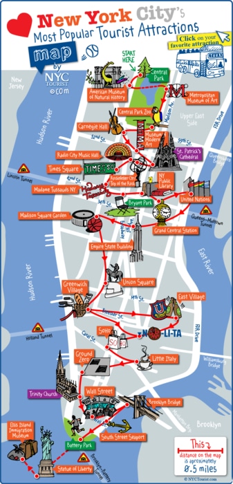
Map of the main attractions in New York
Central Park map
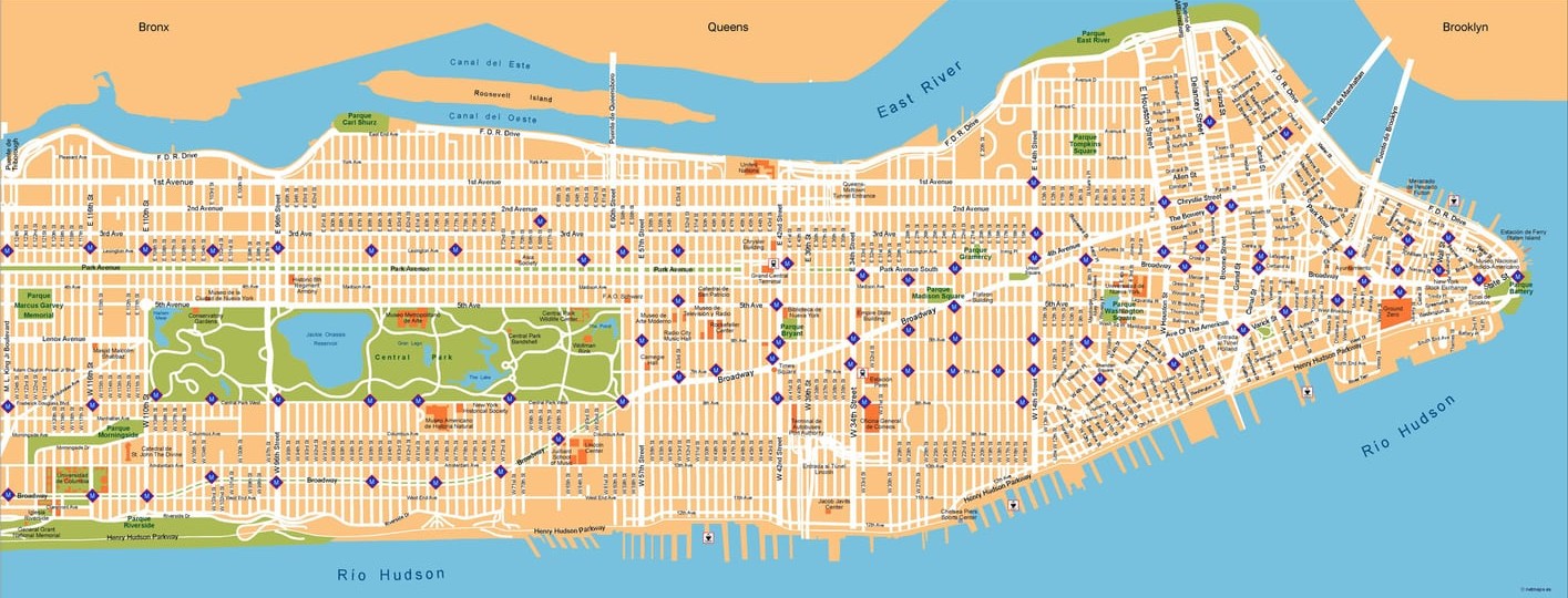
New York street map
New York neighborhood map
New York subway map
New York road map
High-resolution map of New York
Map of the United States
Map of New York for downloading
The New York tourist map below will help you to get an initial idea of the main tourist attractions in the city.
Interactive map of New York
I‘ve created the following interactive map of New York so you can find all the essential places to visit in NYC . You can find museums, the most emblematic skyscrapers in the city, parks – everything!
But if you think I’ve forgotten an interesting tourist spot, leave me a comment and I’ll add it.
At the end of this article, I explain how you can check this map when you’re offline, so you can always take it with you and use it during your trip .
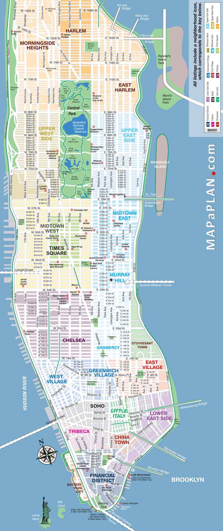
Manhattan is the most popular area of New York among tourists, so it’s essential to have a map to locate the main attractions of New York. The following Manhattan map is also very useful because you can locate the different neighborhoods within the island of Manhattan.
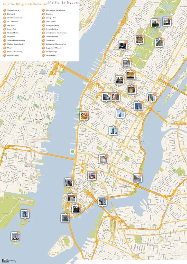
Here is a map of the main attractions in New York . This map is very useful for finding the NY essentials and ideal if you’re going to visit the city for a short time.
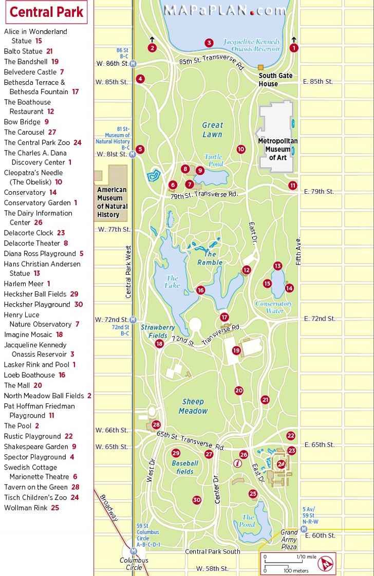
The next one is the Central Park map , one of my favorite places in New York and a place I really recommend you visit, since it’s the green heart of the city. Of course, you’ll need to spend a few hours in it, since it’s not just the largest urban park in New York – it’s also one of the largest in the world. Here you can check all the things to do in Central Park.

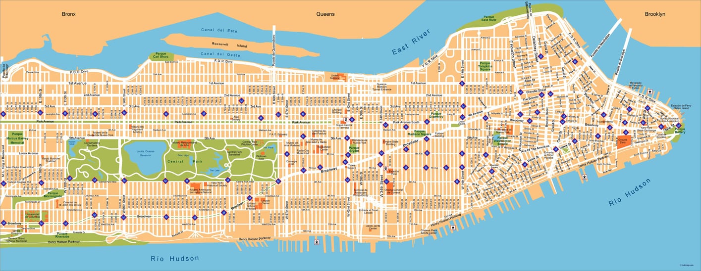
Here is a New York street map so you don’t get lost and can locate yourself quickly. As soon as you understand the numbering system of streets and avenues in New York, there is no way you’ll get lost.
NYC neighborhood map
Some neighborhoods in the city are very well known and probably sound familiar to you. In any case, the following New York neighborhood map will help you to find them quickly.
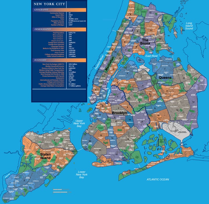
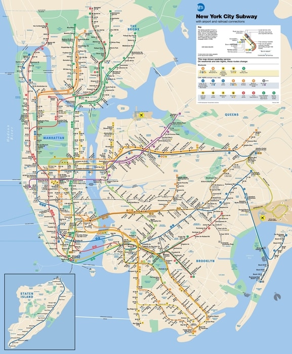
Here is a New York subway map , one of the maps I consider essential for moving around a big city like this one. Taking the subway in New York can be a bit difficult in the beginning, but one day in the city is enough to figure out how it works. Besides, here is a guide on the other ways to get around NYC .
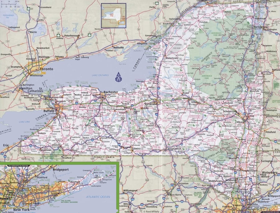
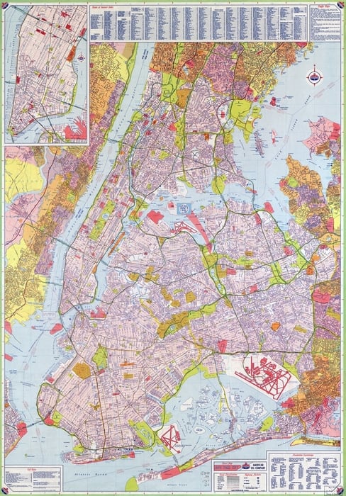
Below is a New York road map. You may not need it since most tourists come to New York City by plane, and if they take an excursion, such as to Philadelphia or Niagara Falls , they book a tour.
In my case, I always go to New York from Philadelphia by car, so this road map of NYC is very useful to me. You can also use it if you decide to rent a car and visit New York State.
If you’re still afraid of getting lost, here is a high-resolution map of NYC so you can zoom in and find any point. In addition, it’s also a great way to make sure you don’t miss a single detail of this great city.
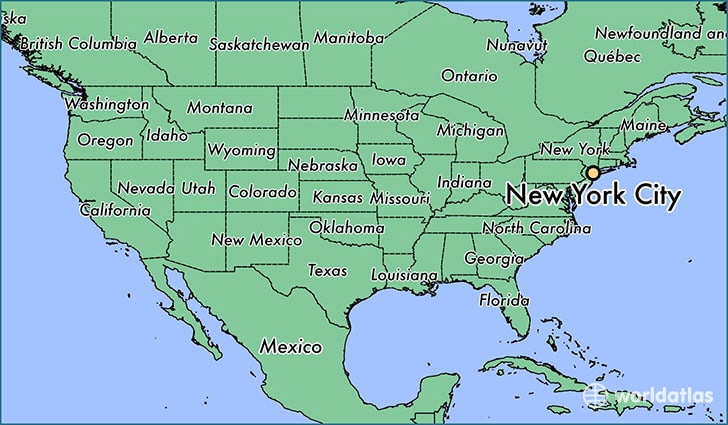
The map of the United States below can help you to locate New York within the country.
Finally, here is a map of NYC for downloading . You can check this map even when you’re offline if you follow the subsequent steps. First, install the Maps.me and Dropbox applications on your smartphone. Both are available for all operating systems and are completely free.

You will have to search “New York” in Maps.me, download the KML file, and save it to Dropbox. Then, open the KML file from your phone using Maps.me so that all the tourist attraction spots are saved. By doing this, you’ll have the interactive map of NYC available on your smartphone.
That’s it! With these maps of New York, you have everything you need to start planning your trip and make the most of the “City that Never Sleeps.”
Don't miss a 5% discount on your HeyMondo travel insurance
and the only one that pays all your medical bills upfront for you!
Ascen Aynat
Leave a Reply Cancel reply
Your email address will not be published. Required fields are marked *
This site is protected by reCAPTCHA and the Google Privacy Policy and Terms of Service apply.

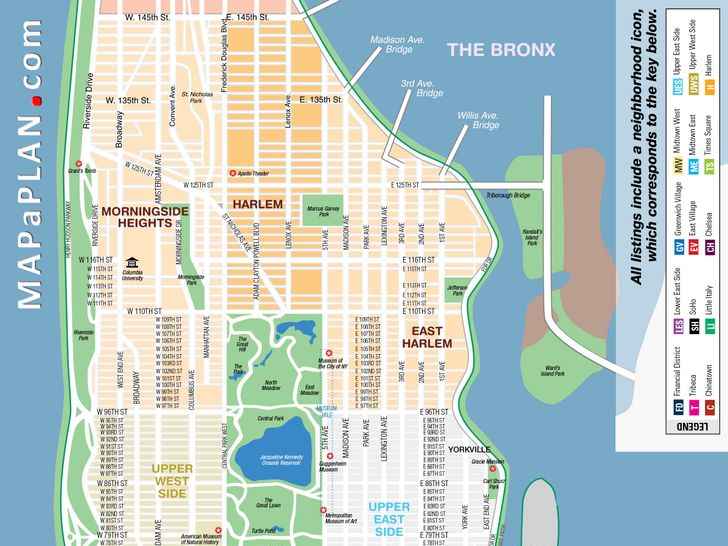
Maps of New York City and Manhattan top tourist attractions
Manhattan streets and avenues must-see places - new york top tourist attractions map.
What to do and what do see in New York?
New York is an urban jungle that has everything to offer to visitors. NY is, along with London and Paris, one of the most visited cities in the world. It is a stunning showcase for contemporary architecture, a breeding ground for new directions in the visual, performing and culinary arts and a capital of commerce, publishing, fashion and finance. New York's museums, neighborhoods, iconic buildings, tourist attractions and shopping opportunities all make for an unparalleled experience for visitors. The city is home to numerous museums, parks, trendy neighborhoods and shopping streets. This is what makes NYC such a wonderful place to visit while at the same time presenting every visitor with the difficult question...What should I see? New York offers some of the world's most recognizable, cherished landmarks and attractions. From Times Square and Central Park to the Empire State Building and The Metropolitan Museum of Art, the island of Manhattan packs more legendary icons into one compact area than any other place on Earth; and that's to say nothing of the City's four other boroughs—The Bronx, Brooklyn, Queens and Staten Island - each of which contains its own roster of must-see destinations. With so much to see and do, a trip to NYC may seem a little overwhelming. To help, we are presenting a set of maps and plans that show the locations of the top tourist destinations. Since the City's full breadth of activities is virtually limitless, we’ve also listed the top ten tourist attractions at the bottom of this page.
New York City subway (metro) map with bus and railroad connections (underground, tube) - New York top tourist attractions map
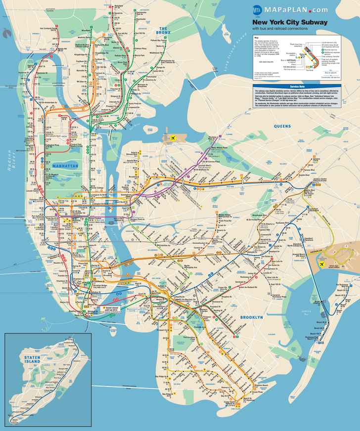
You can view, download or print a full, high resolution (detailed, large) version of this image by clicking on the plan itself
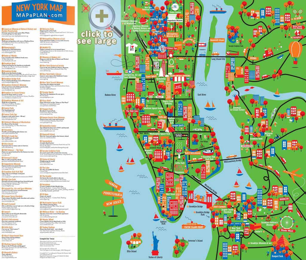
Great things to do with kids / children interactive and colorful map - New York top tourist attractions map
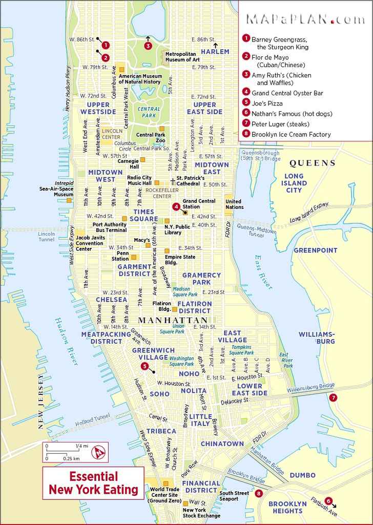
Most popular / essential / famous eating places - New York top tourist attractions map
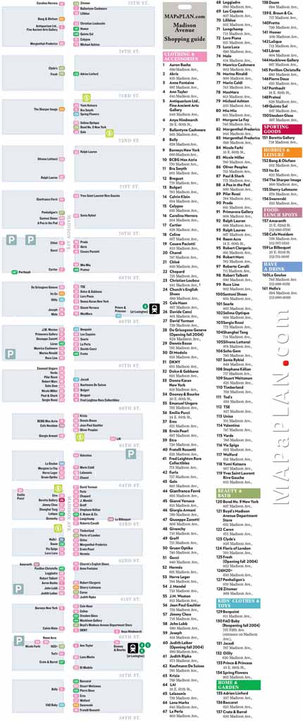
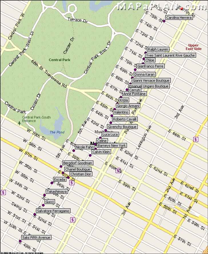
Madison Avenue shopping guide and directory list - New York top tourist attractions map
Central Park favourite and free destination spots - New York top tourist attractions map

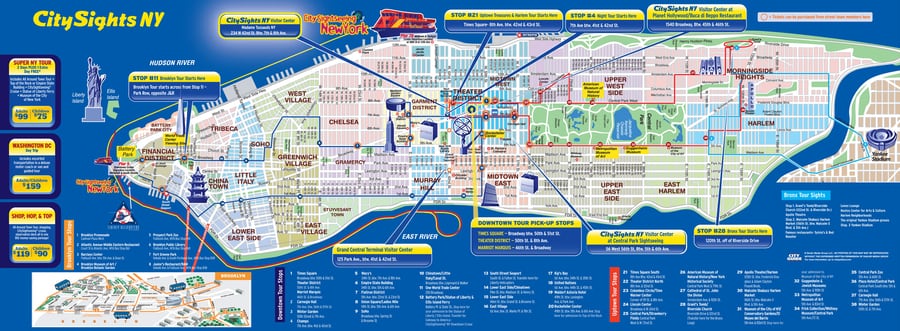
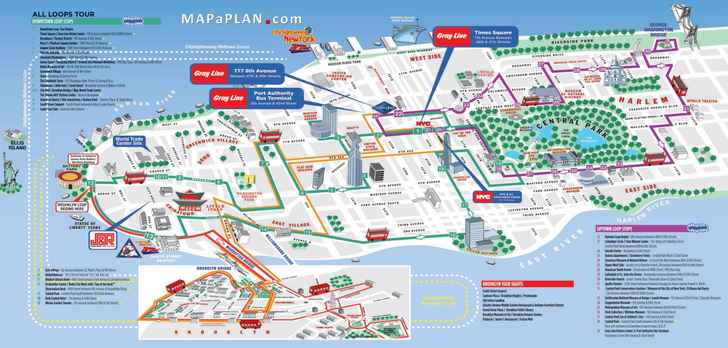
Double decker / open deck / hop-on-hop-off bus / All Loops package tour - New York top tourist attractions map
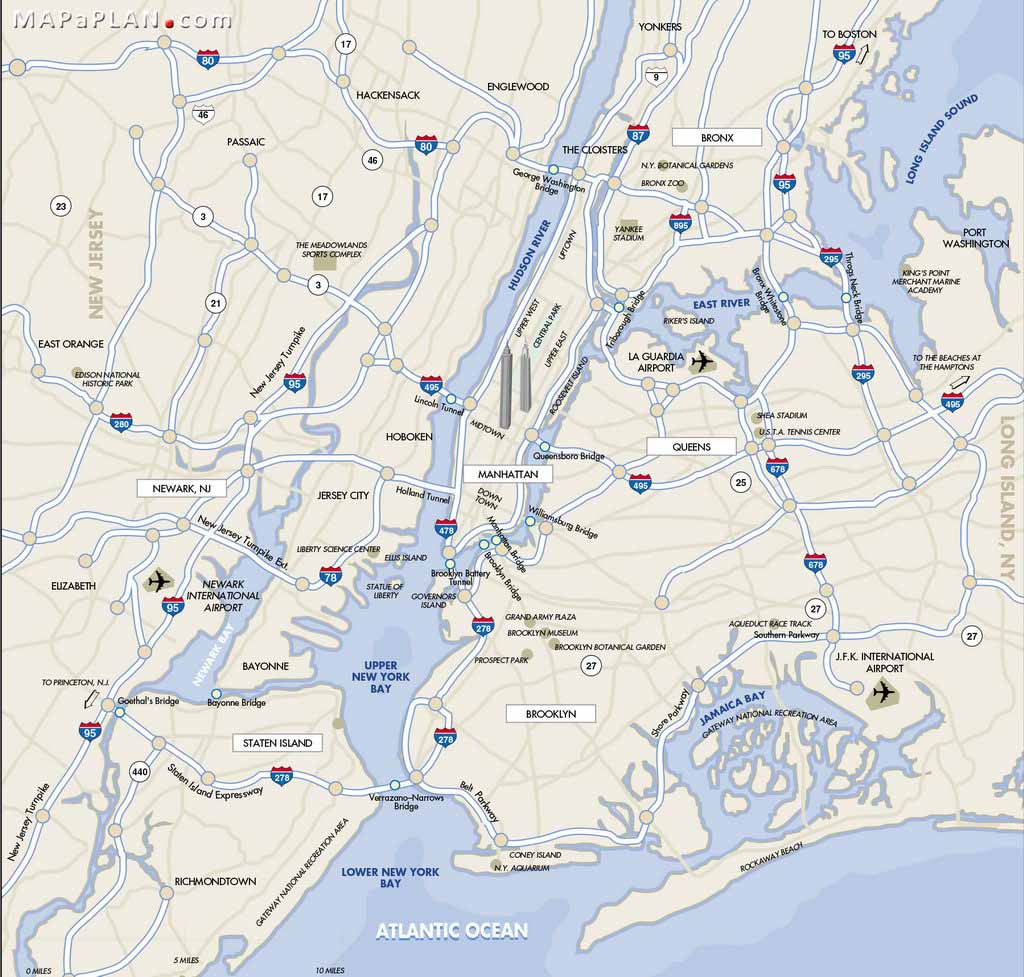
New York City borders with airports - Outline simple poster - New York top tourist attractions map
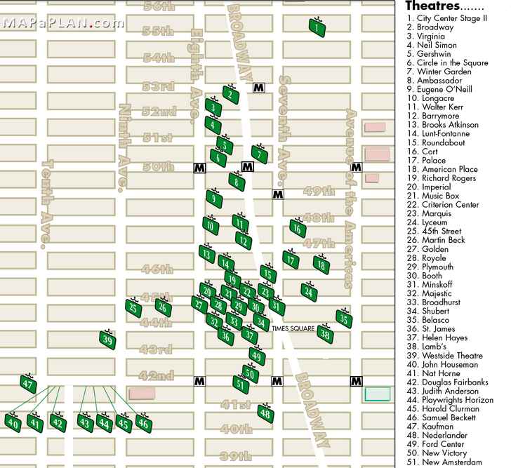
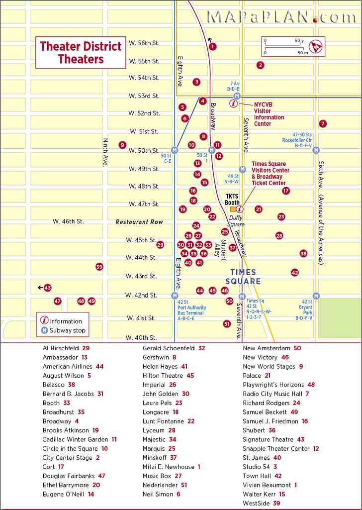
Theatres district Broadway / Off-Broadway / Off-Off-Broadway - New York top tourist attractions map
Manhattan bus travel routes - New York top tourist attractions map

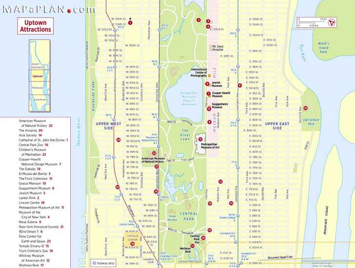
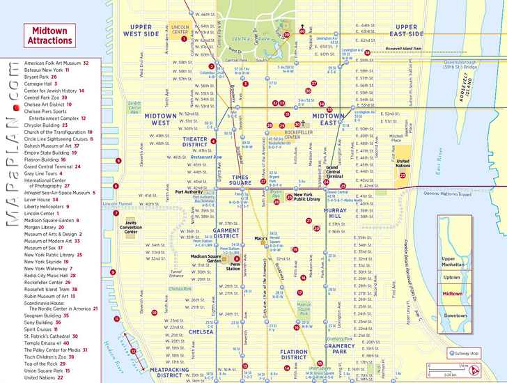
What to do and where to go in Uptown Manhattan - New York top tourist attractions map
Midtown Manhattan sightseeing trip planner - New York top tourist attractions map
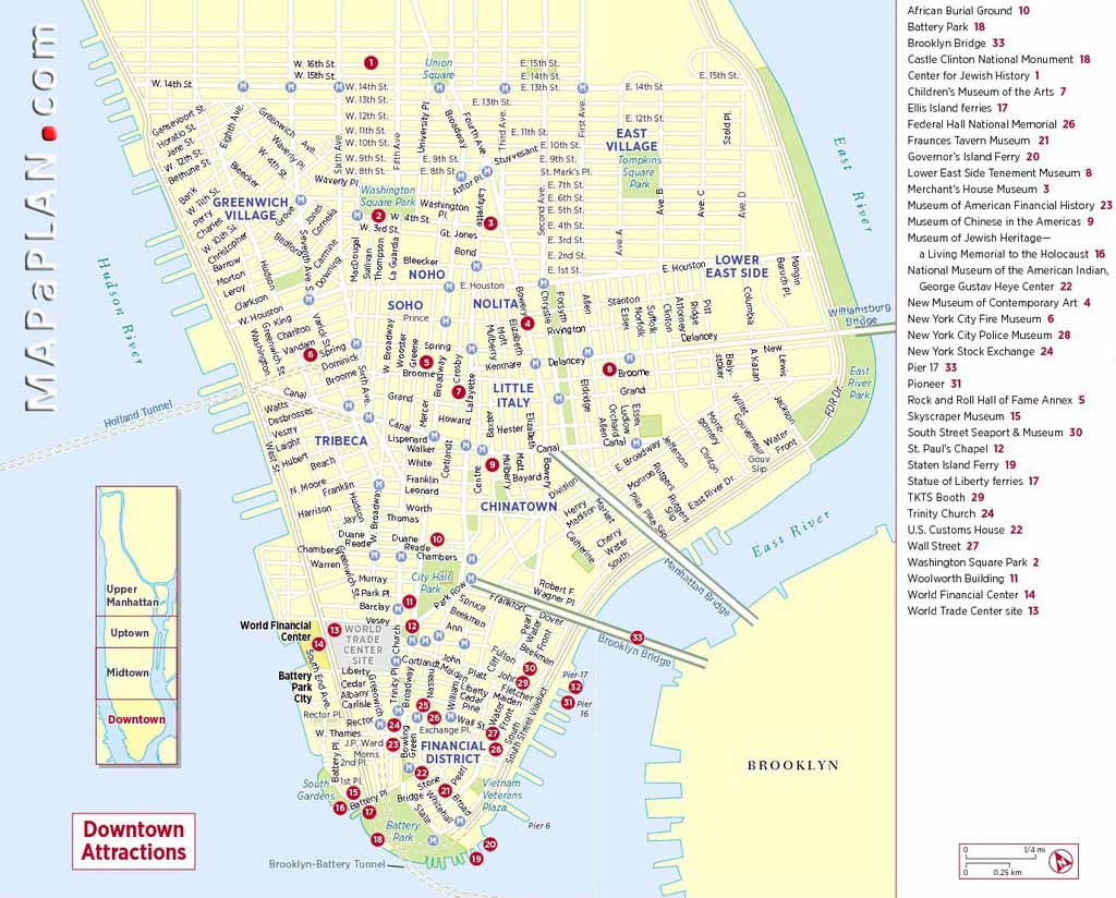
Downtown Manhattan major points of interest list - New York top tourist attractions map
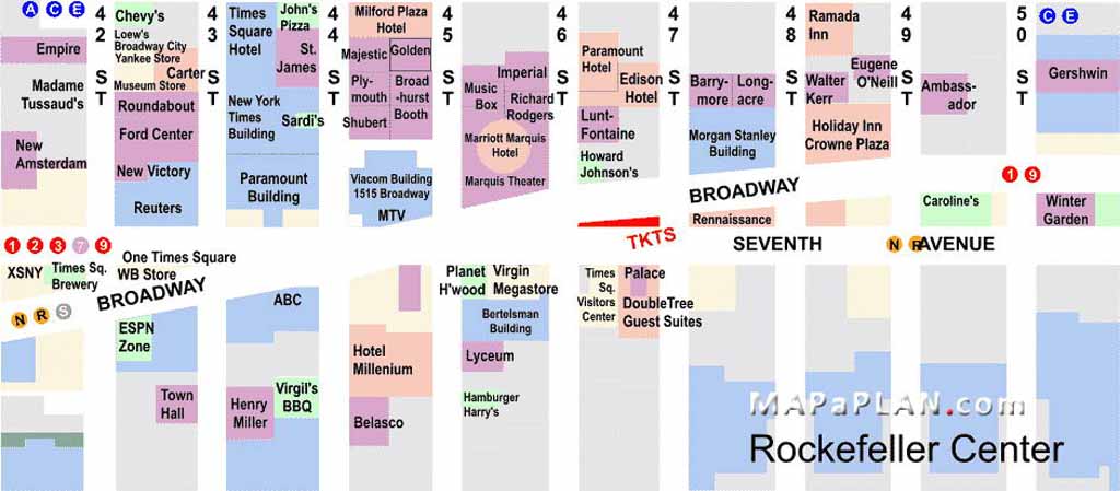
Midtown Manhattan shopping guide directory list - New York top tourist attractions map

Times Square plan with places of interest - New York top tourist attractions map
Madison Avenue luxury and high-end stores shopping - New York top tourist attractions map
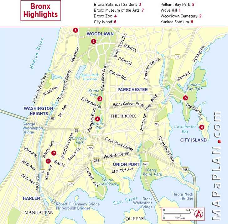
Bronx highligths visitors guide - New York top tourist attractions map
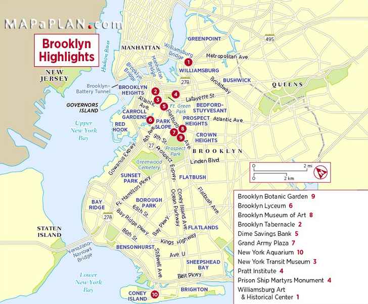
Brooklyn visitor main highligths - New York top tourist attractions map
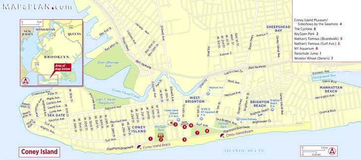
Conney Islond visiting highlights - New York top tourist attractions map
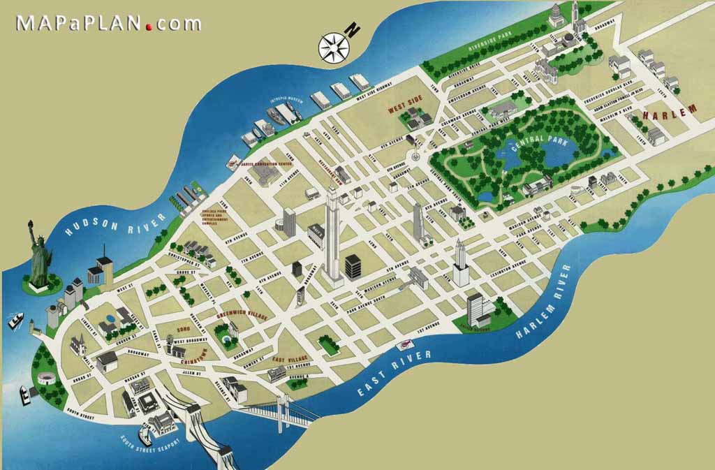
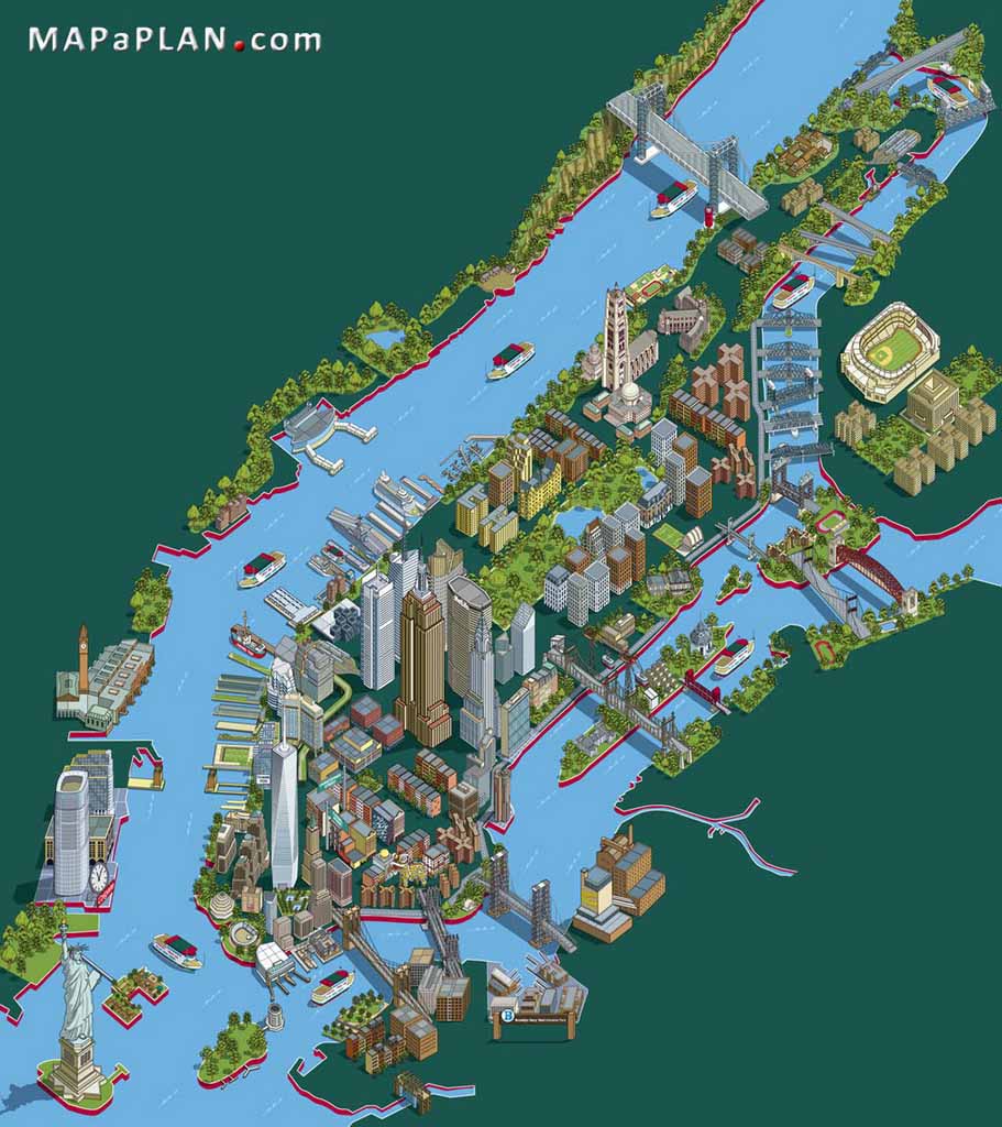
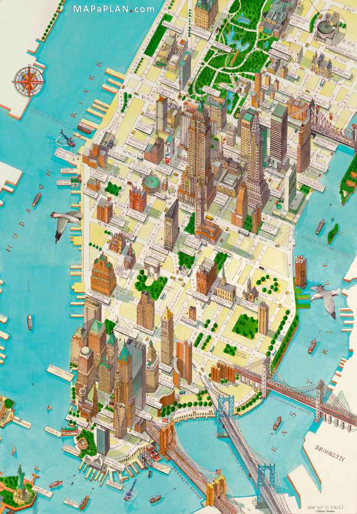
Manhattan 3d buildings - New York top tourist attractions map
Landmarks aerial birds eye view - New York top tourist attractions map
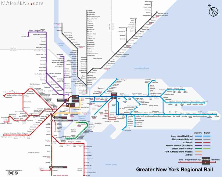
Greater New York regional rail railroad train lines - New York top tourist attractions map
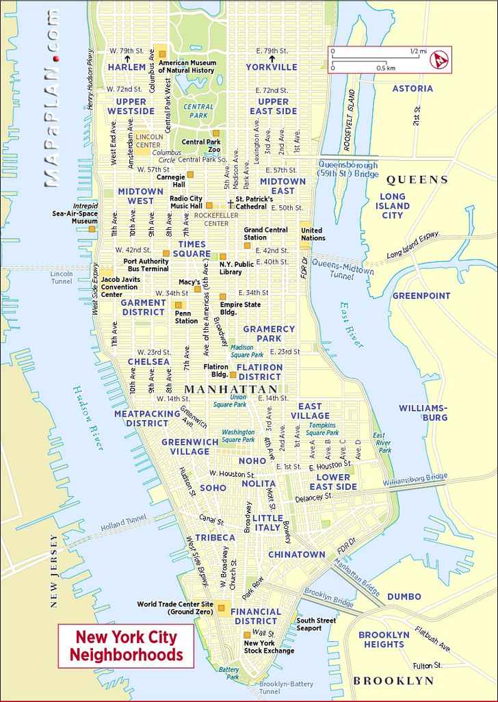
New York city central neighbourhoods - New York top tourist attractions map
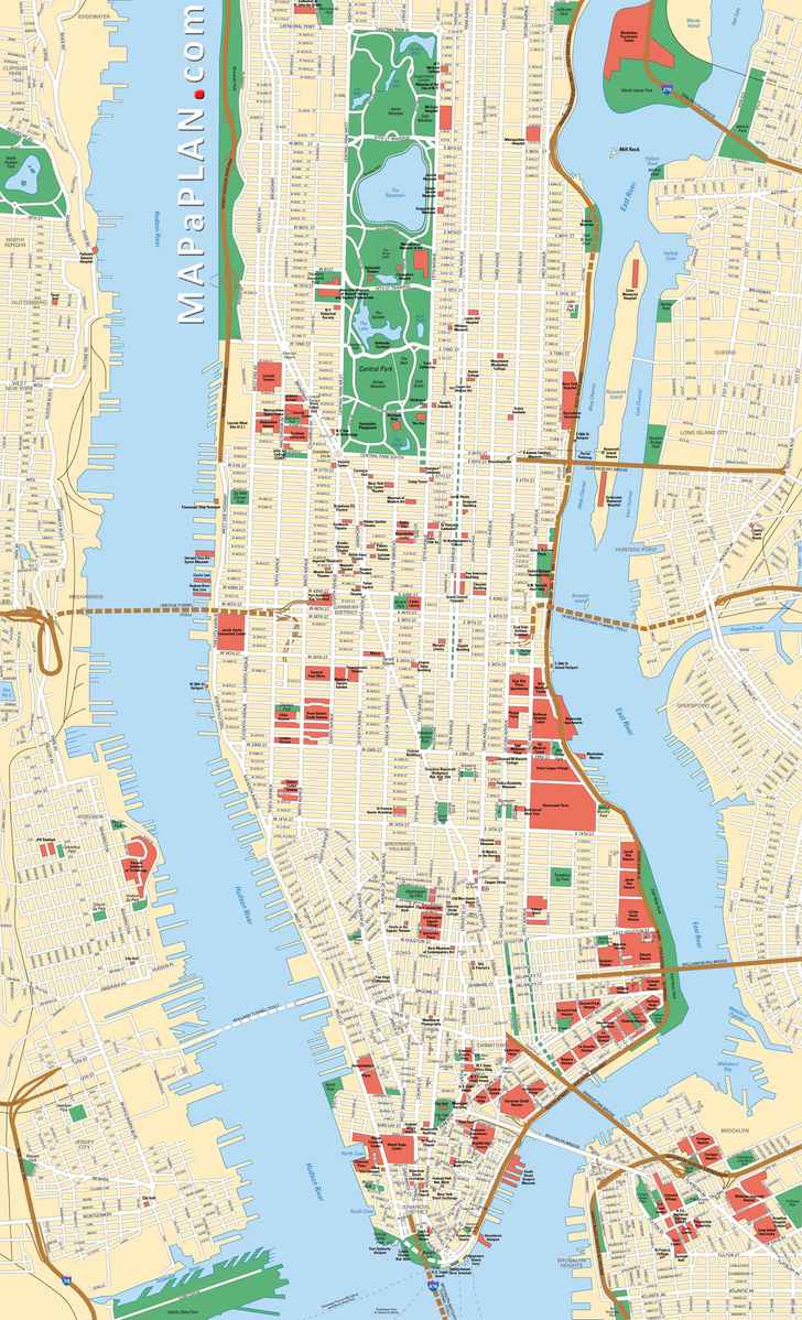
Manhattan streets and avenues must see places - New York top tourist attractions map
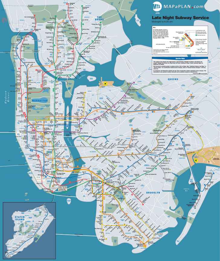
Late night subway (metro) stations and transit service - New York top tourist attractions map
A to Z best sights in a week on google map - New York top tourist attractions map
Locations to visit in three days - New York top tourist attractions map
Central Park places - New York top tourist attractions map
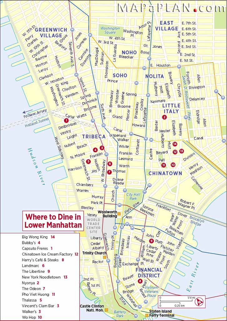
Best atmosphere dining restaurants in Lower Manhattan - New York top tourist attractions map
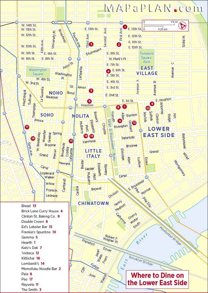
Best food dining restaurants Lower East Side - New York top tourist attractions map
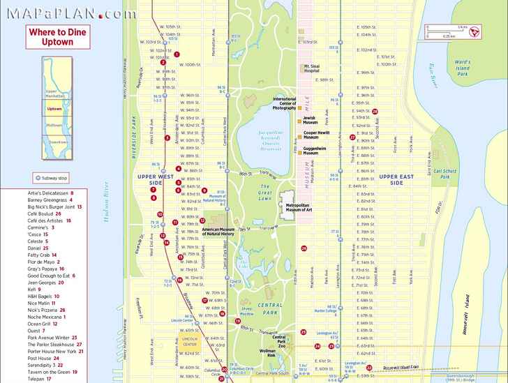
Best decor dining restaurants in Uptown - New York top tourist attractions map
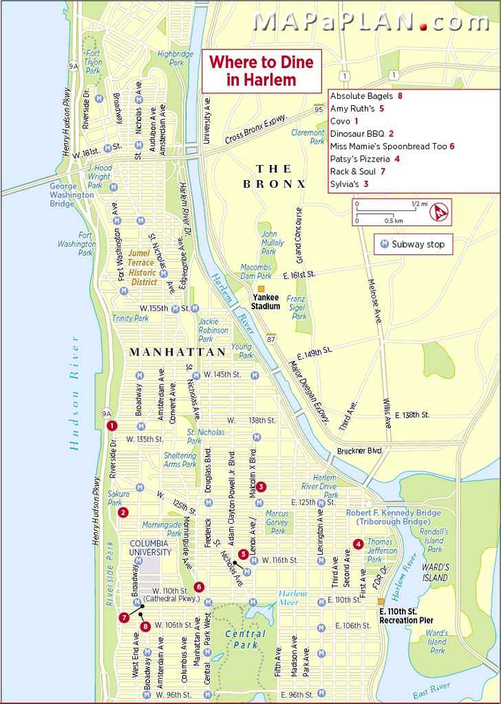
Best ambience dining restaurants in Harlem - New York top tourist attractions map
Manhattan historical map with bridges - New York top tourist attractions map
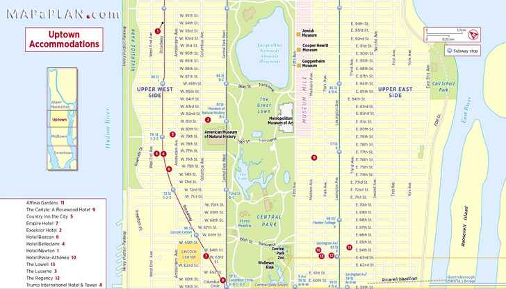
Uptown Manhattan hotel accommodations - New York top tourist attractions map
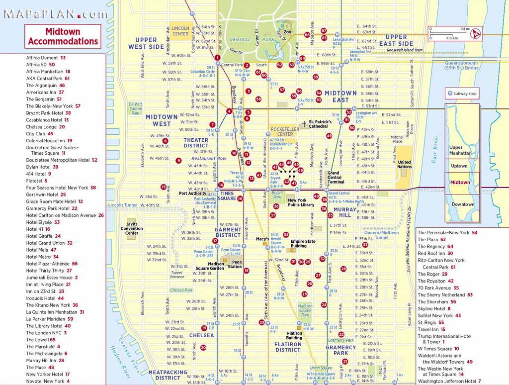
Midtown Manhattan hotel accommodations - New York top tourist attractions map
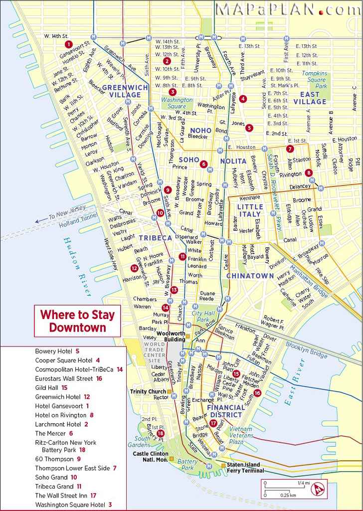
Downtown Manhattan hotels - New York top tourist attractions map
Theatrer district theatres - New York top tourist attractions map
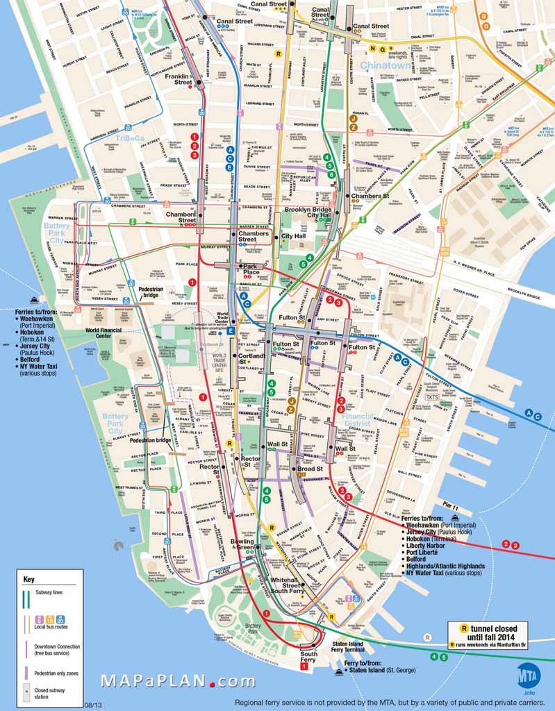
Lower Manhattan key bus map - New York top tourist attractions map
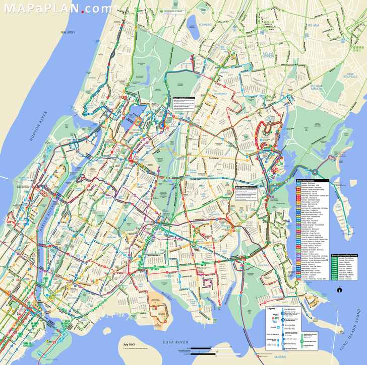
Bronx bus map - New York top tourist attractions map
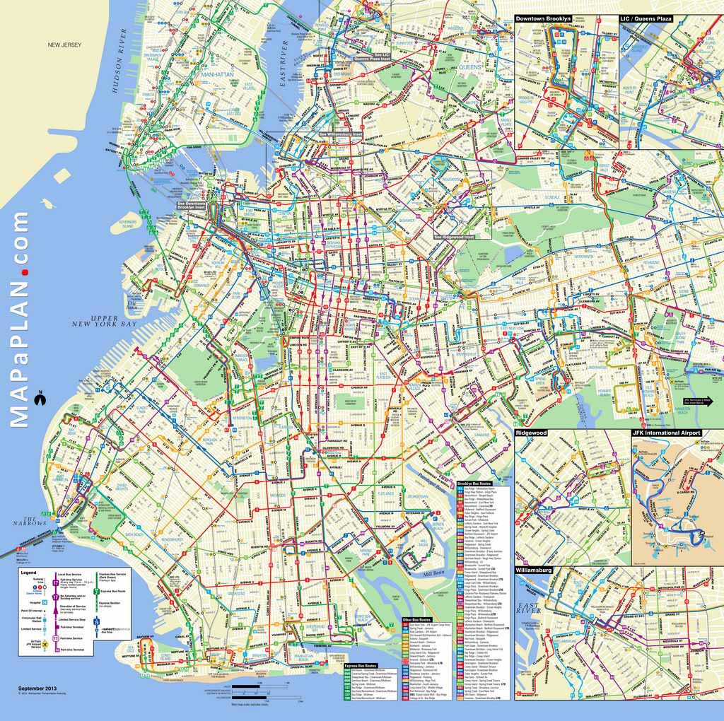
Brooklyn bus map - New York top tourist attractions map
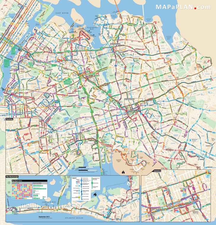
Queens bus map - New York top tourist attractions map
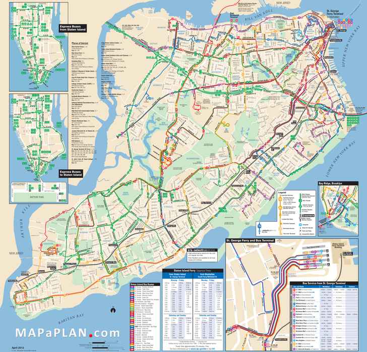
Staten Island bus map - New York top tourist attractions map
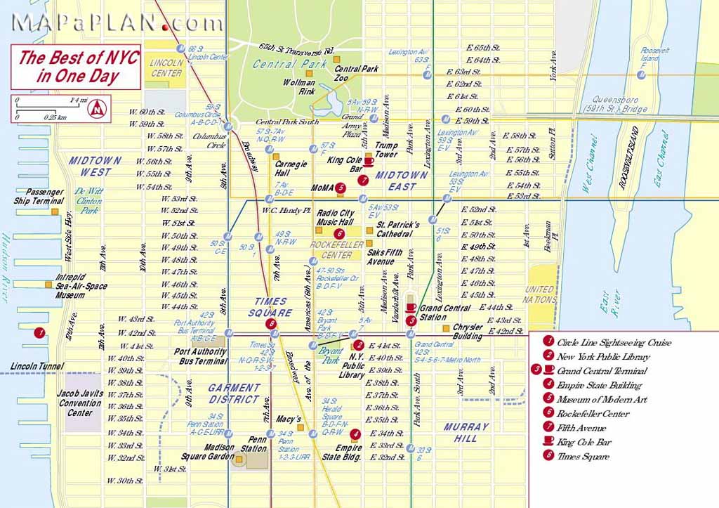
The best of NYC in one day - New York top tourist attractions map
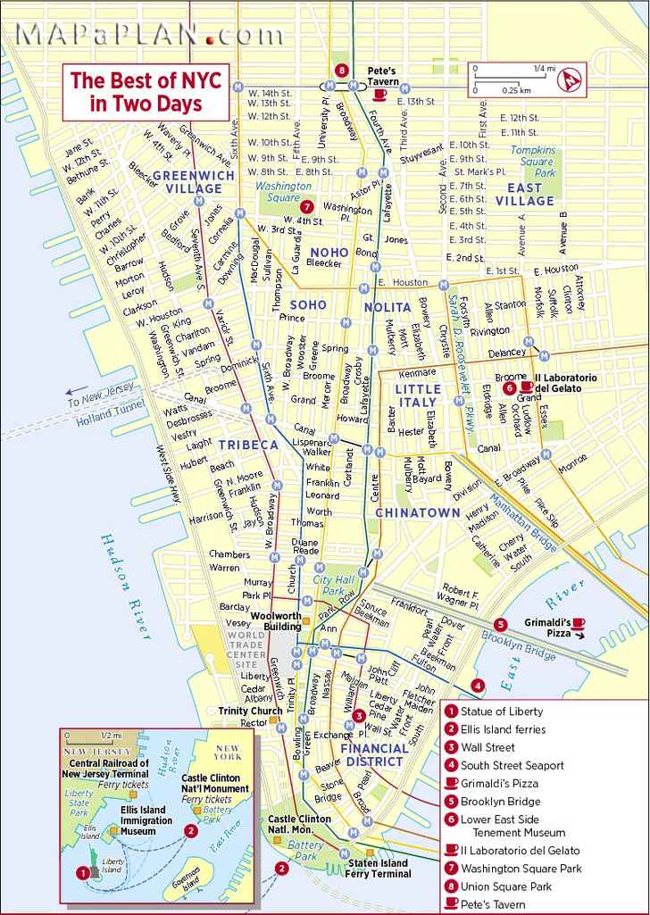
The best of NYC in two days - New York top tourist attractions map
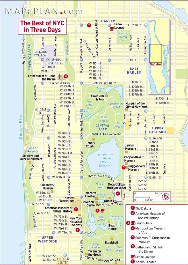
The best of NYC in three days - New York top tourist attractions map
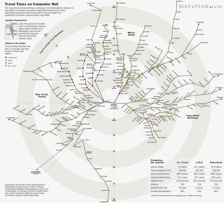
Penn Station and Grand Cntral commuter rail travel times - New York top tourist attractions map
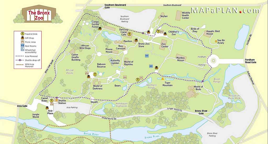
Bronx zoo fun locations - New York top tourist attractions map
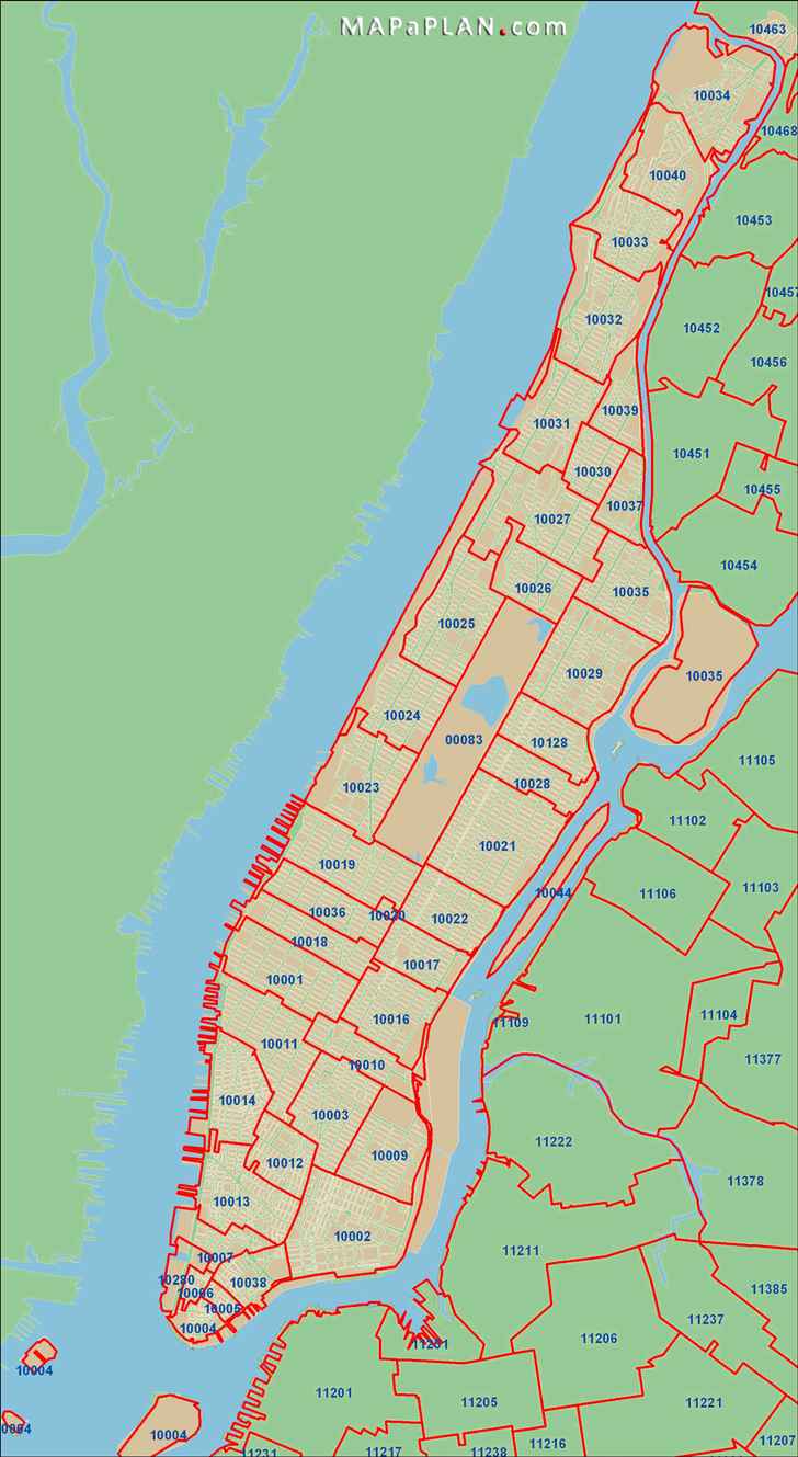
Postal areas zip codes - New York top tourist attractions map
Brooklyn Heights highlights - New York top tourist attractions map
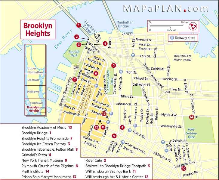
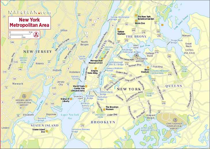
New York metropolitan boroughs interesting sites - New York top tourist attractions map
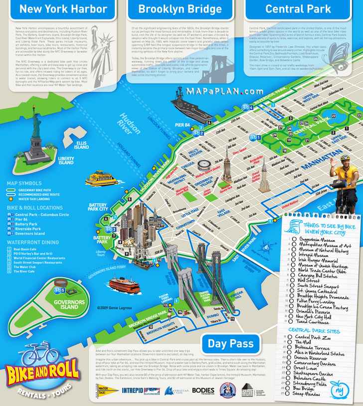
Bike and Roll points of interest tour - New York top tourist attractions map
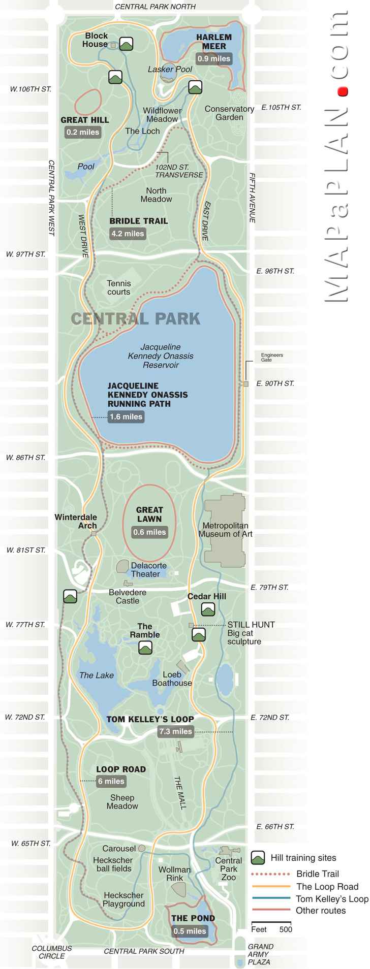
Central Park running tracks / jogging routes - New York top tourist attractions map
New York must-see top ten tourist attractions shown on our maps
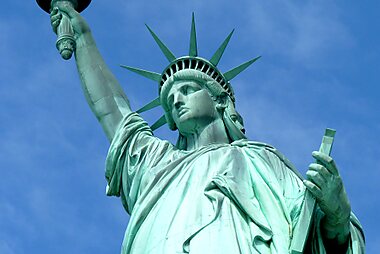
Statue of liberty.
The Statue of Liberty has become an American symbol of freedom and welcome to the immigrants who come to the USA looking for a better life. It's the popular tourist attractions in New York. The crown of Lady Liberty, as the statue is often affectionately called, has seven spikes, symbolizing the Seven Seas across which liberty should be spread. In her left hand she holds a tablet with the Declaration of Independence and in her right hand a torch, symbolizing Enlightenment.
Empire State Building
The Empire State Building has captured the attention of young and old alike: every year, millions of tourists flock to the Empire State Building. You can visit the Empire State Building's observatory on the 86th floor from where you have a magnificent view over the city of New York. The Empire State Building is situated south of Midtown, away from the skyscraper clusters in midtown and in the financial district downtown, so this is one of the few places in Manhattan where you have an open 360 degrees view.
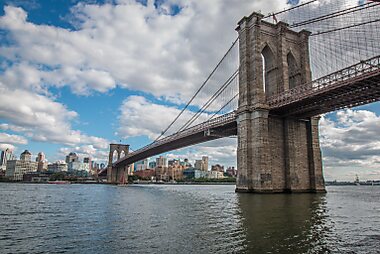
Brooklyn Bridge
The Brooklyn Bridge, built between 1869 and 1883, connects Manhattan with New York. The bridge is one of the most magnificent tourist attractions in New York. The impressive bridge spans the East river between Brooklyn and Manhattan and stretches for a length of 5989 ft, about 1.8 km. The length between the large towers is 1595.5 ft (486 meter). This made the Brooklyn bridge the world's largest suspension bridge.
American Museum of Natural History
The American Museum of Natural History presenting exhibits to the general public in the Central Park Arsenal building more than 30 years ago, American Museum of Natural History has been devoted to bringing the public cutting-edge anthropological and natural history information and displays - profiling both the past and present. From giant dinosaur skeletons to a state-of-the-art planetarium, the four floors of the museum are a giant playground for both adults and children, especially those who love animals and science.
Central Park, Manhattan, New York City
located in the center of Manhattan. Its design is an example for city parks around the world. Central Park is situated in Manhattan between 59th and 110th street and between Fifth and Eight Ave. The park offers several lakes, theaters, ice rinks, fountains, tennis courts, baseball fields, many playgrounds and other facilities. It is also home to the Central Park Zoo and the Metropolitan Museum of Art. Especially during the weekends, when cars are not allowed into the park, Central Park is a welcome oasis in this hectic city.
Chrysler Building
Chrysler Building regarded as one of America's greatest buildings, and the Chrysler Building is often on the cover of architectural books and magazines. The Chrysler building is one of the last skyscrapers in the Art Deco style. The gargoyles depict Chrysler car ornaments and the spire is modeled on a radiator grille. Since it was restored in 1996 it glitters again like it must have in the 1930s. And the building's Art Deco interior is even more magnificent than its exterior. The marble floors and many Art Deco patterns such as on the stylish elevator doors make the Chrysler Building one of New York's most beautiful office towers.
Times Square
Overflowing with oversized restaurants, enormous neon billboards, bustling Broadway theaters and massive souvenir shops and chain stores, Times Square is an attack on the senses. Discounted tickets to theaters are available at Times Square's busy TKTS booth. If you're feeling really brave, you can join the massive crowd on New Year's Eve to watch the ball drop.
Fifth Avenue
There are enough over-the-top shopping opportunities on Fifth Avenue to satisfy everyone's taste. Women will love browsing and buying at stores like Bergdorf-Goodman, Louis Vuitton, Prada, Emanuel Ungaro, Gucci, Ferragamo, and Versace. Men can check out Bergdorf Men, Brooks Brothers, the NBA Store as well as the famous Apple Store. Place to looking for something shiny or sparkly such as jeweler to the stars, Bulgari, Cartier, Tiffany and Company, Van Cleef and Arpels, and Fortunoff.
Grand Central Terminal
Completed in 1913, Grand Central Terminal – more commonly, if technically incorrectly, called Grand Central Station – is another of New York's stunning Beaux Arts buildings, boasting 75ft-high, glass-encased catwalks and a vaulted ceiling bearing a mural of the constellations streaming across it – backwards (the designer must've been dyslexic). The balconies overlooking the main concourse afford an expansive view; perch yourself on one of these at around 5pm on a weekday to get a glimpse of the grace that this terminal commands under pressure.
Staten Island Ferry
If you want to see the New York Harbor up close. The Staten Island Ferry serves commuters traveling between Staten Island and Lower Manhattan. The Staten Island Ferry is an attraction fit for young and old. Take the staten island ferry you can enjoy a wonderful view of the harbor and all it has to offer. Among the sights to take in from either side of the vessel, are Governors Island, the Statue of Liberty, the Brooklyn Bridge, lower Manhattan and Wall Street's skyscrapers, Ellis Island, and the Verrazano Narrows Bridge connecting Staten Island to Brooklyn.
Related keywords
2023, 2024, 2025, 2025, 2026, 2027, 2028, 2029, download, print, printable, free, detailed, aerial, bird's eye, guide, map, plan, planner, travel, sightseeing, visit, trip, tour, tourist, what to do, where to go, things to do, must see, top attractions, points of interest, places, sites, sights, buildings, spots, destinations, locations, landmark, museum, in a week, in 3 days, one day, city, route, metro, subway, underground, tube, bus, kids, chidren, top 10, top ten, popular, famous, interesting, highlights, restaurants
Seating plans and charts of entertainment venues showing detailed seat and row numbers
- Aberdeen P&J Live virtual seating layout
- Amsterdam Ziggo Dome Arena virtual seating layout
- Anaheim Honda Center virtual seating layout
- Atlanta Mercedes-Benz Stadium virtual seating layout
- Atlanta State Farm Arena virtual seating layout
- Auckland Eden Park Stadium virtual seating layout
- Auckland Go Media Mount Smart Stadium virtual seating layout
- Auckland Spark Arena virtual seating layout
- Belfast Odyssey SSE Arena virtual seating layout
- Belfast Windsor Park National Football Stadium virtual seating layout
- Birmingham Resorts World Arena NEC virtual seating layout
- Birmingham Utilita Arena NIA virtual seating layout
- Boston TD Garden virtual seating layout
- Brighton Centre virtual seating layout
- Brisbane Gabba Cricket Ground virtual seating layout
- Calgary Scotiabank Saddledome virtual seating layout
- Cardiff International Arena virtual seating layout
- Cardiff Millennium Principality Stadium virtual seating layout
- Carrara People First Stadium virtual seating layout
- Charlotte Bank of America Stadium virtual seating layout
- Charlotte Spectrum Center virtual seating layout
- Chicago Soldier Field virtual seating layout
- Chicago United Center virtual seating layout
- Cincinnati Paycor Stadium virtual seating layout
- Cleveland Browns Stadium virtual seating layout
- Cologne Lanxess Arena virtual seating layout
- Dallas American Airlines Center virtual seating layout
- Dallas AT&T Stadium virtual seating layout
- Denver Ball Arena virtual seating layout
- Denver Empower Field at Mile High virtual seating layout
- Derby Velodrome Arena virtual seating layout
- Detroit Ford Field virtual seating layout
- Detroit Little Caesars Arena virtual seating layout
- Dublin 3Arena virtual seating layout
- Dublin Aviva Stadium virtual seating layout
- East Rutherford MetLife Stadium virtual seating layout
- Edmonton Northlands Coliseum virtual seating layout
- Fairfax EagleBank Arena virtual seating layout
- Foxborough Gillette Stadium virtual seating layout
- Gdańsk-Sopot Ergo Arena virtual seating layout
- Glasgow OVO Hydro Arena virtual seating layout
- Glendale Desert Diamond Arena virtual seating layout
- Glendale State Farm Stadium virtual seating layout
- Houston NRG Stadium virtual seating layout
- Indianapolis Gainbridge Fieldhouse virtual seating layout
- Indianapolis Lucas Oil Stadium virtual seating layout
- Jacksonville EverBank Stadium virtual seating layout
- Kansas City GEHA Field Arrowhead Stadium virtual seating layout
- Kraków Tauron Arena virtual seating layout
- Las Vegas Allegiant Stadium virtual seating layout
- Las Vegas Sphere virtual seating layout
- Las Vegas T-Mobile Arena virtual seating layout
- Leeds First Direct Arena virtual seating layout
- Liverpool M&S Bank Arena virtual seating layout
- London Arsenal Emirates Stadium virtual seating layout
- London O2 Arena virtual seating layout
- London Royal Albert Hall virtual seating layout
- London Stadium (West Ham United Olympic Park) virtual seating layout
- London Tottenham Hotspur Stadium virtual seating layout
- London Twickenham Stadium virtual seating layout
- London Wembley OVO Arena virtual seating layout
- London Wembley Stadium virtual seating layout
- Los Angeles Crypto.com Staples Center Arena virtual seating layout
- Los Angeles Kia Forum Inglewood virtual seating layout
- Los Angeles SoFi Stadium virtual seating layout
- Louisville KFC Yum! Center virtual seating layout
- Manchester AO Arena virtual seating layout
- Manchester Co-op Live virtual seating layout
- Melbourne Marvel Stadium virtual seating layout
- Melbourne Rod Laver Arena virtual seating layout
- Memphis FedExForum virtual seating layout
- Miami Hard Rock Stadium virtual seating layout
- Miami Kaseya Center Arena virtual seating layout
- Milwaukee Fiserv Forum virtual seating layout
- Minneapolis Target Center virtual seating layout
- Minneapolis U.S. Bank Stadium virtual seating layout
- Nashville Bridgestone Arena virtual seating layout
- Nashville Nissan Stadium virtual seating layout
- New Orleans Caesars Superdome virtual seating layout
- New Orleans Smoothie King Center virtual seating layout
- New York Barclays Center virtual seating layout
- New York Madison Square Garden virtual seating layout
- Newark Prudential Center virtual seating layout
- Newcastle Utilita Arena virtual seating layout
- Nottingham Motorpoint Arena virtual seating layout
- Oakland Oracle Arena virtual seating layout
- Oklahoma City Paycom Center Arena virtual seating layout
- Orchard Park Highmark Stadium virtual seating layout
- Orlando Camping World Stadium virtual seating layout
- Orlando Kia Center virtual seating layout
- Oslo Spektrum Arena virtual seating layout
- Oslo Telenor Arena virtual seating layout
- Perth HBF Park Rectangular Stadium virtual seating layout
- Perth HBF Stadium Superdrome virtual seating layout
- Perth Optus Stadium virtual seating layout
- Perth RAC Arena virtual seating layout
- Philadelphia Lincoln Financial Field virtual seating layout
- Philadelphia Wells Fargo Center virtual seating layout
- Phoenix Footprint Center Arena virtual seating layout
- Pittsburgh Acrisure Stadium virtual seating layout
- Pittsburgh PPG Paints Arena virtual seating layout
- Portland Moda Center virtual seating layout
- Queensland Country Bank Stadium virtual seating layout
- Rosemont Allstate Arena virtual seating layout
- Sacramento Golden 1 Center virtual seating layout
- Saint Paul Xcel Energy Center virtual seating layout
- Salt Lake City Delta Center virtual seating layout
- San Antonio Frost Bank Center virtual seating layout
- San Francisco Chase Center virtual seating layout
- San Jose SAP Center virtual seating layout
- Santa Clara Levi's Stadium virtual seating layout
- Seattle Lumen Field virtual seating layout
- Sheffield Utilita Arena virtual seating layout
- St. Louis Enterprise Center virtual seating layout
- Sunrise FLA Live Arena virtual seating layout
- Sydney Qudos Bank Arena virtual seating layout
- Sydney Showground Engie Stadium virtual seating layout
- Tampa Raymond James Stadium virtual seating layout
- Toronto Scotiabank Arena virtual seating layout
- Tulsa BOK Center virtual seating layout
- Uncasville Mohegan Sun Arena virtual seating layout
- Vancouver BC Place virtual seating layout
- Vancouver Rogers Arena virtual seating layout
- Vienna Wiener Stadthalle virtual seating layout
- Washington DC Capital One Arena Center virtual seating layout
- Wellington TSB Arena virtual seating layout
- Winnipeg Canada Life Centre virtual seating layout
- Zürich Oerlikon Hallenstadion virtual seating layout
High resolution, printable travel guide maps of cities showing top tourist attractions
- Amsterdam major tourist attractions maps
- Bangalore major tourist attractions maps
- Bangkok major tourist attractions maps
- Barcelona major tourist attractions maps
- Beijing major tourist attractions maps
- Berlin major tourist attractions maps
- Bruges major tourist attractions maps
- Brussels major tourist attractions maps
- Budapest major tourist attractions maps
- Cambridge major tourist attractions maps
- Chicago major tourist attractions maps
- Copenhagen major tourist attractions maps
- Delhi major tourist attractions maps
- Dubai major tourist attractions maps
- Dublin major tourist attractions maps
- Edinburgh major tourist attractions maps
- Florence major tourist attractions maps
- Frankfurt major tourist attractions maps
- Hong Kong major tourist attractions maps
- Istanbul major tourist attractions maps
- Jaipur major tourist attractions maps
- Las Vegas major tourist attractions maps
- Lisbon major tourist attractions maps
- London major tourist attractions maps
- Los Angeles major tourist attractions maps
- Madrid major tourist attractions maps
- Malaga major tourist attractions maps
- Marrakech major tourist attractions maps
- Miami major tourist attractions maps
- Milan major tourist attractions maps
- Mumbai major tourist attractions maps
- New York major tourist attractions maps
- Oxford major tourist attractions maps
- Paris major tourist attractions maps
- Prague major tourist attractions maps
- Rome major tourist attractions maps
- San Francisco major tourist attractions maps
- Singapore major tourist attractions maps
- Sydney major tourist attractions maps
- Tokyo major tourist attractions maps
- Venice major tourist attractions maps
- Vienna major tourist attractions maps
- Washington DC major tourist attractions maps
- Zurich major tourist attractions maps
Great Maps of New York City
A map can make it easier to avoid getting lost in New York City.
A map of New York City is a valuable tool to use as you plan your trip, but it's also helpful once you arrive. With one of these New York City maps, you'll be able to find your way around easier and plan your days in New York City more effectively.
Streetwise Manhattan Map
The Streetwise Manhattan map is my top choice for visitors to New York City. It has a sturdy laminated finish, making it easy to fold and resilient enough to survive repeat trips to New York City. We especially like the compact size of this map -- unfolded it is only the size of a piece of legal paper. The index covers neighborhoods, places of interest and museums. Subway lines are included, and there is also a map that covers Manhattan buses. Unless you want to explore Queens or Brooklyn, this map is a good choice.
New Yorker's Manhattan Map
Smaller when folded than most of the other maps, this laminated map is a bit softer than the other maps, making it easy to stick in your back pocket. In addition to the street map, there are separate subway and bus maps, which is helpful when you're trying to plan a route on public transportation. Additionally, the subway map covers the entire subway system (not just Manhattan). The comprehensive index covers 100+ attractions, as well as parks and Central Park landmarks. There is also a list of useful phone numbers for transport, emergencies, and airports on one panel of the map.
Official New York City Visitors Map
While not laminated, this map has one advantage over all the others -- it's available for free from the NYC & Company, New York City's official tourism marketing organization. If you chose to request the map in advance online, be sure to allow plenty of time for the map to arrive by mail before you depart. Alternatively, you can pick up a copy of the map at any of New York City's Official Visitor Information Centers .
Free Online New York City Neighborhood Maps
Want your New York City Maps right away? You can print out New York City maps for free with our New York City Neighborhood Maps. Start with the Midtown East map and make your way through the rest.
Getting Around New York City: Guide to Public Transportation
Driving in New York City
Is It Safe in New York City?
Getting To and From LaGuardia Airport in NYC
11 Essential New York City Websites
A One-Day Itinerary for Visiting New York City
New York City Guide: Planning Your Trip
The Best Time to Visit New York City
Best Budget Manhattan Hotels
How to Travel From LaGuardia Airport to Brooklyn by Subway, Bus, and Car
Guide to New York City Marathon
Strategies for Visiting New York City on a Budget
How to Walk the Brooklyn Bridge
Getting to LaGuardia Airport From Brooklyn by Public Transportation
The 18 Best Things to Do in New York City
Best New York City Stores for Foodies
New York Printable Tourist Map
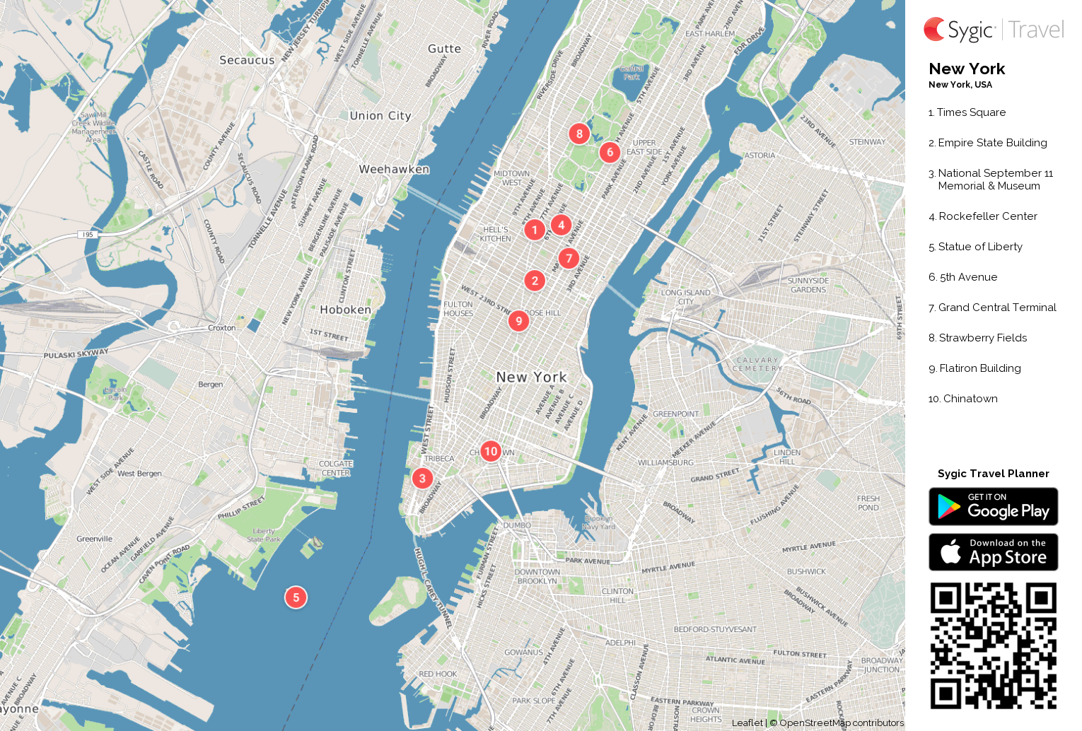
New York City Map: The Attractions

National September 11 Memorial & Museum
Statue of Liberty
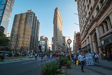
Flatiron Building
Brooklyn Bridge
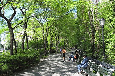
Battery Park

Wall Street

One World Trade Center
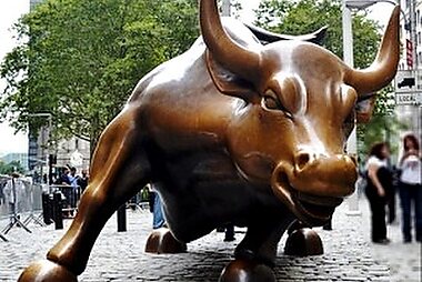
Charging Bull

Trinity Church
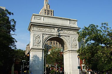
Washington Square Park
Sygic travel - a travel guide in your pocket.

More Tourist Maps
- Privacy Policy
- STOCK 360° TRAVEL VIDEOS

New York City Tourist Map: Your Best 2024 Guide to Exploring the Big Apple
- 12 March 2024
- Blog , New York , Travel
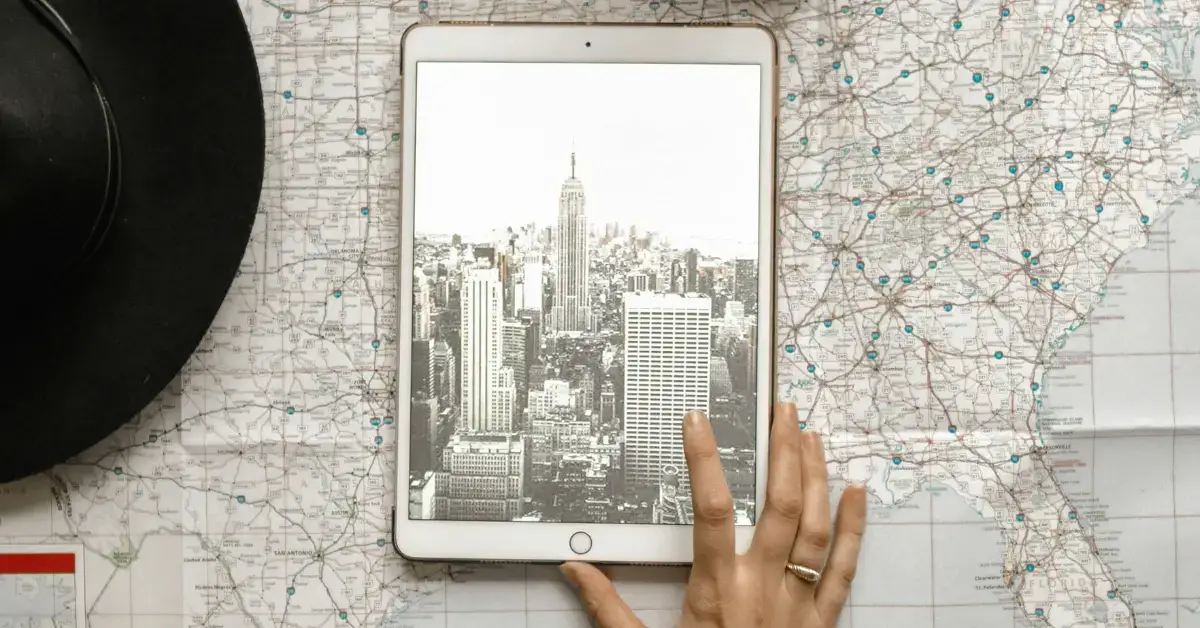
Exploring New York City feels like an endless adventure, and armed with a handy tourist map, you’ll be set to uncover the vibrant layers of the concrete jungle. Imagine you’re strolling through the bustling streets, map in hand, about to discover your next favorite sight. Whether it’s the iconic Empire State Building towering above or the historic depths of the Statue of Liberty, each attraction is a piece of the larger mosaic that is New York.
The city’s vastness is brimming with attractions, and navigating them can be as thrilling as it is daunting. A well-prepared tourist map is your companion that ensures you make the most of your visit. It guides you through the colorful neighborhoods, parks, museums, and landmarks, helping you pinpoint your location amidst the excitement. Forget the worry of getting lost; your tourist map paves the way for a memorable journey through the heart of New York City.
Table of Contents
Planning Your New York City Trip
Embarking on a vibrant journey to New York City requires a strategic plan . Early planning ensures that you soak in the dynamism of the city without missing a beat. Let’s get started on the essentials you’ll need for the adventure that awaits you in the Big Apple.
New York City Tourist Map: Mapping Your Itinerary
To make the most of your New York visit, a detailed map is your best companion. Begin with an interactive map that allows you to not only view all the iconic landmarks but also customize your route. Pinpoint attractions, estimate walking distances, and even set time aside for spontaneous exploration. This NYC map is the cornerstone of an efficient trip planner, guaranteeing that you cover all desired sites with ease.

Transport Options
New York is famed for its extensive public transportation network . Understand your options: the subway, buses, and the metro are at your service for swift city travel. For a deep dive into routes and schedules, a New York interactive map with real-time updates can be immensely helpful. That said, don’t overlook the convenience of yellow cabs for those times when you prefer a direct route to your next destination. Make sure to be aware of the location of airports and train lines to smoothly navigate your arrival and departure from the city.
Manhattan Highlights
As you unfold your New York City Tourist Map, your eyes are immediately drawn to the bustling heart known as Manhattan. Here, an array of iconic sights awaits, including sun-dappled lawns in Central Park and the prestigious halls of world-renowned museums.
Central Park Explorations
Central Park is your urban oasis, sprawling across 843 acres. On your Central Park map, you’ll spot the winding paths leading to Sheep Meadow, a perfect picnic spot, and the Bethesda Terrace, with its stunning fountain and lake views. Art installations and blooming gardens add to the charm of this green wonder in the heart of the city.
- Bethesda Terrace and Fountain : A must-see architectural marvel
- Sheep Meadow : Ideal for picnics and people-watching
- The Conservatory Garden : Beautiful formal gardens for a stroll

Museums and Exhibits
Manhattan is a treasure trove for art enthusiasts and history buffs alike. Head to the Metropolitan Museum of Art (The Met), where you’ll journey through time among over two million works of art. For contemporary enthusiasts, the Museum of Modern Art (MoMA) is your next stop, featuring an exemplary collection of modern and contemporary art.
- The Metropolitan Museum of Art (The Met) : Art from antiquity to the modern era
- Museum of Modern Art (MoMA) : Cutting-edge modern art exhibitions
Beyond museums, you can’t miss the Empire State Building , an Art Deco skyscraper that once stood as the tallest in the world. Your Manhattan adventure wouldn’t be complete without marveling at this and other historic landmarks dotting the skyline.
Brooklyn and Beyond
Exploring Brooklyn means embarking on a journey through vibrant neighborhoods, mingling amongst the lush green spaces, and serendipitously finding oneself amidst a plethora of cultural and natural experiences. You’ll discover pockets of tranquility in urban parks and find your heart racing with exciting recreational opportunities.
Cultural Adventures
As you meander through Brooklyn’s mosaic of communities, you’ll encounter an array of cultural treasures. From the historic carousel in Prospect Park to the ever-evolving street art, these experiences enrich the soul. Brooklyn’s neighborhoods are a tapestry woven with the threads of diversity, each offering a unique cultural feast.
- Williamsburg : Be amazed by live music venues that are the heartbeats of the indie scene.
- DUMBO : Visit this neighborhood for thriving arts, fashion, and design communities.
Natural Escapes
Brooklyn offers an escape to nature without ever leaving the city perimeter. The Prospect Park is a testament to Brooklyn’s natural beauty, offering you miles of paths for running and cycling surrounded by peaceful greenery.
- Brooklyn Botanic Garden : A natural sanctuary that changes with the seasons.
- Green-Wood Cemetery : An unexpected haven for peaceful reflection amidst historical monuments.
Whether it’s the welcoming shade of the park on a summer day or the serene environment for recreational activities, your journey through Brooklyn’s outdoors will be unforgettable.
Family-Friendly Attractions
New York City is a treasure trove for families, with attractions that make the city feel like a playground for both the young and the young at heart. From hand-carved carousels in the heart of Central Park to the awe-inspiring Statue of Liberty , your family is in for an unforgettable adventure.
Interactive Entertainment
Central Park is your go-to for a mix of fun and relaxation. Your children can delight in an iconic horse-drawn carriage ride, or enjoy a merry-go-round spin on the famous Central Park Carousel. For a unique experience, consider boat rentals on the park’s serene reservoir, where you can enjoy the skyline from a different perspective.
Educational Excursions
Museums in New York are anything but ordinary, offering a wealth of knowledge that’s engaging for all ages. The American Museum of Natural History is home to captivating dinosaur fossils, while the interactive exhibits at the Children’s Museum of the Arts ignite creative young minds. Don’t miss the National Museum of Mathematics for hands-on learning or the famed MoMA for inspiring artistic journeys. And for a glimpse of America’s past, a visit to the Statue of Liberty provides a historical outing that will also give you unforgettable views of the city.
Historic Landmarks and Memorials
New York City is a treasure trove of American history, with landmarks and memorials that mark significant events and honor those who shaped the nation.

Walking Through History
When you walk the bustling streets of New York, you’re strolling through layers of history. Grand Central Terminal is not just a transit hub but also an architectural wonder, standing since 1913. The Statue of Liberty , gifted by France in 1886, is a beacon of freedom and a must-visit for anyone interested in the roots of American liberty.
The soaring Empire State Building , opened in 1931, is more than an iconic skyline fixture—it narrates stories of the city’s industrial age prowess. And don’t forget Wall Street , the financial nerve center that has witnessed America’s economic highs and lows over the centuries.
Paying Respects
Central Park offers a green reprieve amid the skyscrapers and is dotted with statues and memorials. Here, you’ll find tributes to heroes and historical figures who left indelible marks on society. Remembrance takes a more solemn turn at sites dedicated to victims and the innocent lives lost in the city’s storied past. Monuments scattered throughout New York serve as touching homages that evoke emotional reflections on the resilience of its people.
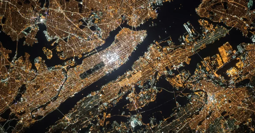
Exploring New York City’s Boroughs
As you unravel the colorful tapestry of New York City, each of the five boroughs offers distinct experiences that are quintessentially New York. From the vibrant neighborhoods to the serene islands, your journey across this metropolis is about to become an unforgettable adventure.
Island Retreats
Staten Island presents a serene escape with the Staten Island Ferry providing not just transportation, but also remarkable views of the Manhattan skyline and the Statue of Liberty. Once there, the lush greenery of the borough invites you for a tranquil retreat amidst the city bustle.
Neighborhood Discoveries
Dive into the diversity of neighborhoods across the boroughs. Feel the pulse of Manhattan as you explore the iconic streets of SoHo with its fashionable boutiques and cobblestone streets, or wander through Little Italy and Chinatown where cultural heritage meets modern day. The East River separates Manhattan from the culturally rich borough of Queens, where neighborhoods like Astoria boast a vibrant dining scene. And let’s not forget the Bronx, where you can explore the historic Yankee Stadium and the city’s largest park, Pelham Bay Park.
Arts and Entertainment
New York City is a vibrant hub for the arts, offering an array of experiences that cater to every taste. From the bright lights of Broadway to the diverse musical rhythms that echo through the streets, and the prestigious museums housing centuries of creativity, the city is your stage to an unparalleled cultural journey.
Broadway Shows
Attending a Broadway show is an essential New York City experience. Renowned for their high-caliber performances, these productions take place in the heart of Manhattan and feature both classic hits and contemporary musicals. Secure your tickets to witness the magic of Broadway and be part of a tradition that has sparked the imaginations of millions.
- The Majestic Theatre: Home to the iconic “Phantom of the Opera”
- The Gershwin Theatre: Currently showing “Wicked”
- The New Amsterdam Theatre: Known for the Disney musical “Aladdin”
Music and Film Festivals
New York’s busy calendar includes numerous film and music festivals , boasting everything from indie films to chart-topping artists. The Tribeca Film Festival ushers in a celebration of storytelling, while music aficionados can revel in the eclectic lineup at the Governors Ball Music Festival . Each event offers a unique opportunity to immerse yourself in the city’s dynamic cultural landscape.
- Governors Ball: An annual festival featuring a variety of genres.
- New York Film Festival: Showcases the latest in cinema excellence.
In your artistic explorations, don’t miss the Metropolitan Museum of Art and Museum of Modern Art (MoMA) , where the world’s treasures await to inspire and mesmerize you. The Met is an emblem of artistic diversity, housing over two million works, while MoMA delights with its focus on contemporary masterpieces.
Shopping and Fashion
Exploring the vibrant streets of New York City, you’ll encounter a world of fashion that’s as diverse as it is exciting. Stepping onto Fifth Avenue , you’ll be greeted by flagship stores of renowned global brands and luxury boutiques, making it a premier destination for anyone with a love for high fashion.
Key Shopping Districts:
- Soho : Known for its cobblestone streets and trendy vibe, Soho is packed with fashion-forward boutiques and high-end stores.
- Chinatown: A contrasting atmosphere where you can find eclectic items, unique gifts, and affordable fashion.
- Times Square: A bustling hub with vast selections of souvenir shops and mainstream retail outlets.
In Fashion Squares:
- Herald Square: Home to the classic Macy’s flagship store.
- Union Square: Offers a mix of big-name brand stores and indie shops.
The Garment District is a must-visit for fashion enthusiasts, with showrooms and small retailers offering everything from fabrics to bespoke clothing. Here, the ‘Fashion Walk of Fame honors industry icons and inspires all who stroll through.
For more detailed navigation and tips on the best shopping experiences, make sure to utilize a New York City Tourist Map , integrating these must-visit shopping destinations to enhance your NYC fashion journey.
New York City by Water
Exploring New York City by water offers you a unique perspective of the iconic skyline and the bustling waterfront. Glide along the Hudson River or the East River and discover the beauty of the city from a fresh viewpoint. Charmingly friendly boat tours will introduce you to famous sights like the Statue of Liberty and the distant shores of Staten Island.
River Excursions
Hudson River : You can find a variety of boat rentals to cruise along the Hudson River. Whether you prefer a guided tour or to captain your vessel, the Manhattan coastline offers stunning views, especially at sunset.
East River : Not just a boundary between boroughs, the East River is your gateway to NYC’s heritage. Regular ferries connect you to Brooklyn, Queens, and beyond, offering a glimpse into the everyday life of New Yorkers as well as panoramic views of the skyline.
Statue of Liberty by Boat
Visiting the Statue of Liberty is a must-do by boat. You’ll sail from Battery Park directly to this beacon of freedom. Dedicated ferries often include a stop at Ellis Island , allowing you to experience an integral piece of America’s history where millions of immigrants first set foot in the United States.

Frequently Asked Questions
Navigating New York City can be overwhelming, but having the right tourist map can enrich your experience. Let’s tackle some of the most common inquiries to help you make the most out of your visit to the Big Apple.
How can I find a detailed tourist map of Manhattan for free?
To obtain a comprehensive and free tourist map of Manhattan, check out the NYC Insider Guide , which offers a printable map highlighting key attractions.
Can you recommend some must-see spots in Lower Manhattan for first-time visitors?
Lower Manhattan is brimming with history and sights; pay a visit to the 9/11 Memorial, Wall Street, and Battery Park. Each spot tells a unique story of the city’s past and present.
Where can I get a tour guide or a map of New York City streets at no cost?
For a no-cost street map or tour guide of NYC, you can visit New York City’s official tourism website , which provides a plethora of resources for travelers.
What are some free activities to do in New York City for tourists?
Indulge in free activities like exploring Central Park, walking the High Line, or attending TV show tapings. New York City offers a wide array of experiences without any expense.
Which part of New York City is considered the most tourist-friendly?
Midtown Manhattan is often deemed the most tourist-friendly area, with iconic landmarks like Times Square, Rockefeller Center, and Broadway theaters at your fingertips.
Can I use printable maps of New York City for my trip?
Yes, there are printable maps available online. For instance, Visit A City provides an interactive tourist map that you can print and use during your trip.
Do you have any Questions or Tips for other Travellers, who want to travel New York City? Feel free to drop us a Comment down below.
Daniel Quass
Related posts.

New York to Austin: A 2024 Guide to Effortless Relocation
- 2 April 2024

New York to Charleston Flights: Your 2024 Guide to Easy Travel

New York to Pittsburgh Road Trip: Your 2024 Guide to the Scenic Route

New York to New Orleans Flight: Your 2024 Guide to a Smooth Journey
Leave a reply cancel reply.
Your email address will not be published. Required fields are marked *
Add Comment *
Save my name, email, and website in this browser for the next time I comment.
Post Comment

- New York City Rail Map
- NJ Transit Map
- NYC Path Map
- Long Island Rail Road (LIRR) Map
- Metro North Railroad (MNR) Map
- Manhattan Bus Map
- Brooklyn Bus Map
- Queens Bus Map
- Staten Island Bus Map
- Bronx Bus Map
New York City Attractions Map
Big bus hop on hop off bus map, city sights ny tour map, circle line sightseeing tour map.
- NYC Boroughs & Districts Map
- Manhattan Neighborhoods Map
- Brooklyn Neighborhoods Map
- Queens Neighborhoods Map
- Staten Island Neighborhoods Map
- Bronx Neighborhoods Map
- New York City Airports Transportation Map
- John F Kennedy Airport & Terminal Map (JFK)
- Newark Liberty Airport & Terminal Map (EWR)
- LaGuardia Airport & Terminal Map (LGA)
- New York City Bike Route
- Citi Bike Stations Map

New York City Tourist Map
You can find on this page the map of New York City monuments, the map of New York City tourist buses and the map of NYC river cruises. New York City is the most visited city in United States with 11.5 million tourists per year. Thanks to its numerous monuments, museums, sightseeings, landmarks and attractions, New York City was declared World Heritage Site by UNESCO.
New York's five boroughs each have their own particularities and charm. The main tourist sites are located in the borough of Manhattan. You will find Central Parc, Times Square, the business district of the Financial District, the Empire State building and a magnificent view of the Statue of Liberty. Discover NYC's most emblematic museums such as the MOMA, the MET and the Guggenheim Museum. Then board a yellow taxi to discover Brooklyn, Queens or the Bronx which offer very different landscapes and interesting visits. All our maps of the monuments are free of charge to help you plan your trip.
Nyc sightseeing map
In New York City you can visit:
- museums: Guggenheim Museum, Ellis Island Immigration Museum, American Museum of Natural History, Museum of Modern Art (MoMA)
- monuments: Statue of Liberty
- neighborhoods: Soho, Chinatown, Little Italy
- squares: Times Square
- different attractions: Central Park, National September 11 Memorial, Empire State Building, Rockefeller Center
The city is divided into 5 famous neighborhoods: Manhattan, Brooklyn, Queens, the Bronx and Staten Island. Each area of New York City offers must-see sights and secret corners.
- Manhattan concentrates the main tourist curiosities: Uper East Side, Wall Street, Chinatown, Central Park, Soho as many emblematic districts which make Manhattan an exciting district which attracts millions of tourists.
- The Bronx is separated from Manhattan by the Harlem River. This borough, now more secure, attracts more and more people. You will discover the South Bronx (the real Little Italy) and the Yankee Stadium.
- Brooklyn is the most populated district and qualified as an artists' district. Multi-cultural, Brooklyn offers a contemporary and trendy atmosphere.
- Queens attracts the trendy young generation. Queens is rich in atypical places, parks and architecture.
- Staten Island is the nature district, with multiple sports activities. It is the ideal district to recharge your batteries and take a break.
Nyc hop on hop off
The Big Bus of New York City is an original way of visiting NYC and discover its monuments, museums, attractions while getting on and off at your disposal. This concept of hop on hop off bus or open-top double-decker buses offers a network of 2 tourist tours and routes and 30 stops with commentary in 10 languages.
The Big Bus tour takes you to the heart of Manhattan to discover all the points of interest and monuments of the borough: the Empire State Building,Times Square,Central Park and the Statue of Liberty. Big Bus New York is the only sightseeing bus offering live commentary in English (pre-recorded in 10 languages), Wi-Fi and access to over 25 bus stops throughout the city so you can get on and off whenever you want. The buses are double-decker and open-top. You can see the different routes and all the stops on the map.
Among all the stops, 10 are a must: Times Square, Chinatown, Wall Street, Empire State Building, Brooklyn Bridge, Central Park, Metropolitan Museum, Madison Square Garden, Little Italy and the Statue of Liberty.
Four different tours are offered:
- Uptown Loop: the Upper East Side which is home to some of New York's most popular museums such as the Guggenheim and the Metropolitan Museum of Art. The loop also takes you through Midtown, passing the Grand Central Terminal and the famous Chrysler Building.
- Downtown Loop: The lower part of Manhattan passes through the Flatiron District, Union Square, Greenwich Village and Times Square.
Cruzeiro nova york
City Sights NY is a second hop on hop off bus company with open roofs to discover the city of NYC via a tour. City Sights NY offers 6 lines, 4 tourist bus lines and 2 river cruise lines. Tours are commented in 9 languages.
The CitySightseeing New York City buses pass by all the must-see sights in Manhattan and Brooklyn.
CitySightseeing NYC buses offer 4 routes:
- The Downtown tour (2h30): discover the must-see sights of Midtown and Lower Manhattan. The starting point of this tour is Times Square. You will pass by the Empire State Building and Battery Park and explore New York neighborhoods such as SoHo, Little Italy and Chinatown.
- Uptown Tour (2 hours): The Uptown Loop covers the northern part of Manhattan. This tour also starts at Times Square and goes around Central Park. During this tour, you will discover the American Museum of Natural History, The Apollo Theater in Harlem, the Guggenheim and the Central Park Zoo.
- The Brooklyn Tour (1h30): The Brooklyn Tour is an in-depth discovery of Brooklyn that includes 8 stops in Brooklyn. This tour will allow you to discover several must-see sites in Brooklyn (Barclays Center, the Brooklyn Botanic Garden, the Brooklyn Public Library...).
- The Nocturnal tour (2 hours): discover the most beautiful illuminated places of the city. You will have the opportunity to enjoy a magnificent view of the Manhattan skyline from Brooklyn.
Nyc river cruises
The Circle Line Sightseeing of New York City is a regular river hop on hop off shuttle service transporting passengers on the Hudson River and East River to visit New York City.
With Circle Line cruises you will discover the sights of New York while enjoying a cruise. All Circle Line cruises depart from Pier 83, near the Intrepid Museum. Each cruise will allow you to enjoy views of Manhattan's skyline, the One World Observatory, the Statue of Liberty and Ellis Island.
There are several Circle Line sightseeing cruises in NYC :
- The Circle Line Best of NYC Cruise is a 2.5 hour cruise during which you will discover all of Manhattan. This cruise goes around the island of Manhattan. You will see the skyline, Yankee Stadium, Queens, Brooklyn, The Bronx and other sites. You will pass under iconic bridges such as the Brooklyn Bridge and the Manhattan Bridge that connect Manhattan to other boroughs in New York.
- The Circle Line Landmarks Cruise allows you to see only the major sights of NYC. The cruise lasts 1h30: you will pass under the Brooklyn Bridge and you will see emblematic sites such as the Empire State Building and the Statue of Liberty. You will also have the opportunity to enjoy beautiful views of Manhattan's skyline.
- The Circle Line Harbour Lights Cruise is a 2 hour cruise that allows you to enjoy a view of the skyline at night!
- The Circle Line Liberty Cruise lasts 1 hour. You will pass in front of the Statue of Liberty and enjoy views of the Manhattan skyline

Map of New York to print: find the essential maps here
Map of new york to print: the city map, new york neighborhood map, manhattan plan, new york public transport map to print, airport transport plan, new york subway map to print, new york bus map to print, map of iconic places in new york, map of new york landmarks, map of places of interest in new york.
First of all, you can download the New York City official map by clicking here. You can even print it from home! I strongly recommend it, because it is very well done. In fact, you will find a list of the main attractions and their location on the map.
The main tourist attractions are in Manhattan and Brooklyn, which are arguably the liveliest areas of the city. That said, you will obviously find something to do in Queens, Bronx or Staten Island.
Here's a screenshot of part of this shot, where you can easily find your way around using the clues on the sides of the map.
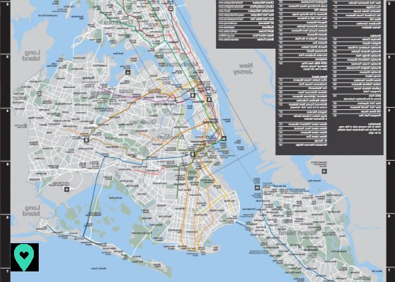
Note that rather than printing them, you can order these cards for free (you will just have to pay the postage) from the official NYC GO website.
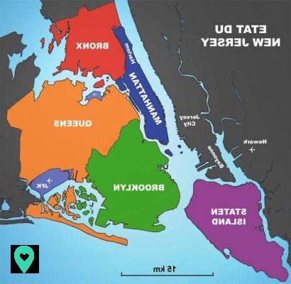
New York is divided into five quarters : Manhattan, Brooklyn, the Bronx, Queens and Staten Island. Each borough you have many surprises in store and offers you to dive into a very special atmosphere :
- Manhattan : New York's most famous neighborhood, Manhattan is made up of several neighborhoods. In Manhattan, you can discover the main tourist attractions of the city and go shopping on Fifth Avenue in particular.
- Brooklyn : if in the past it was infamous, this district is now very famous and appreciated by tourists. Located not far from Manhattan, Brooklyn is worth a stop! You can visit the famous Brooklyn Bridge or the botanical garden, an ideal place to rest and recharge your batteries away from the hustle and bustle.
- The Bronx : if the Bronx had a bad reputation, today its image has changed. It is pleasant to walk there. You can visit the botanical garden as well as the Italian quarter of the city. Don't hesitate to go and explore the Arthur Avenue retail Market. you can find good Italian things there.
- Queens : in this area, you can enjoy the beach, stroll through Flushing Meadows Corona Park and discover interesting museums like MoMa PS1.
- Staten Island : this district is famous for its green spaces. During your visit, plan to stop at Clove Lakes Park and the Island's Botanical Garden. It's very nice.
Here is a map locating the five districts of New York:
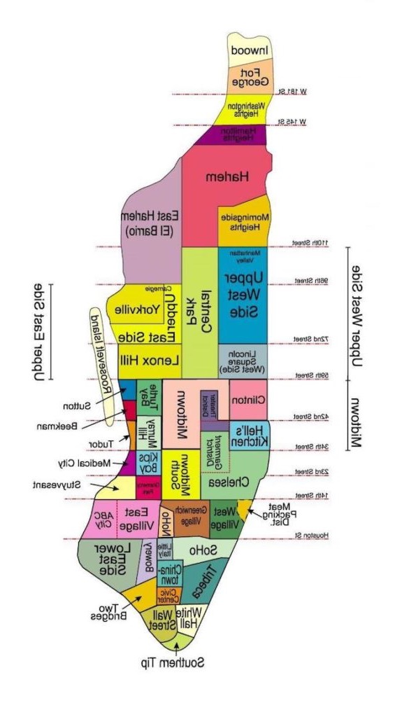
Manhattan is made up of several neighborhoods. To help you get your bearings, here is a map of Manhattan:
The first plan you are looking for in New York transport is undoubtedly the one connecting the various airports of the city to downtown Manhattan or other neighborhoods.
Also, don't worry: whether you arrive at JFK, LaGuardia or Newark Liberty, you will easily get to downtown.
Here is a plan highlighting your different possibilities, including Airtrain and the MTA trains. You can download and print the high definition version by clicking here.

Then you will probably have to take the New York subway. The latter serves the city very well and is an economical option for getting around the Big Apple. Indeed, with 24 lines and 422 stations , you should be able to move around easily!
Here is therefore a map of the metro network to print (download the high definition version by clicking here). That said, don't panic: you can easily find some at paper format (and free) at all stations in the city.
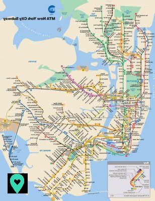
In addition, if you live or want to travel to the vicinity of New York, there is also a network of commuter trains . The latter notably covers New Jersey, Long Island as well as the Bronx, Queens and Brooklyn.
The network is made up of the following 4 networks: New Jersey Transit (NJ Transit), Porth Authority Trans-Hudson (PATH), Long Island Rail Road (LIRR) and Metro North Railroad (MNR).
These 4 trains hold 29 lines and 423 stations . You can access the PDF map of the regional train network by clicking here.
Finally, it is also possible to travel by bus in Manhattan. Slower and depending a lot on traffic, it is however pleasant to move around while admiring the city. If you have time, this is a good option to help you navigate your way and discover new places .
Also, you can find the Manhattan bus map in PDF format by clicking here.
If you count move around Brooklyn , there is also a bus network serving this borough very well. You will find it in PDF format to print it here.
Los of your stay in New York, you will visit a multitude of emblematic places . Monuments, places of interest ... The Big Apple is full of sites to discover: Empire State Building, Statue of Liberty, Times Square, Brooklyn Bridge, Central Park and many more! To help you locate them, here is a map to print.
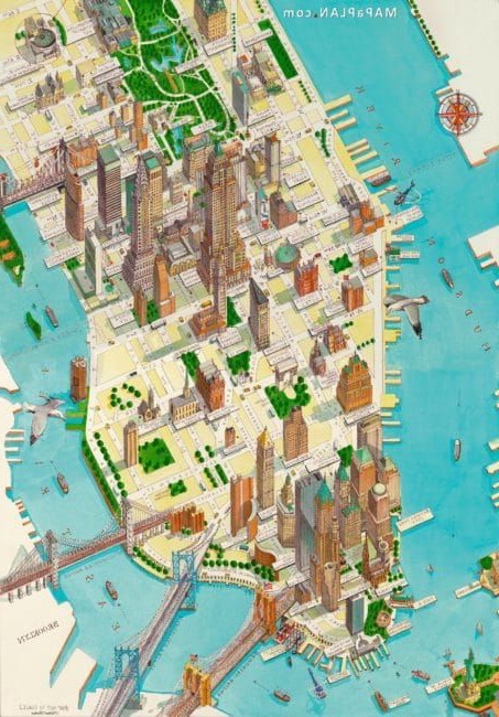
And here ! Thanks to these plans, you should be able to navigate and navigate the Big Apple more easily. Do not hesitate to print them and soak up them, just to pass for a local before even arriving in New York!
And then, while you are in your preparations, don't forget your Pass! Check out my article on the New York City Pass and New York Pass, and take your pick. This will save you time and money. Have a nice trip !
Related Items
Prepare your suitcase for New York: the checklist so you don't forget anything!

US plug: the special US adapter to connect your devices

All the essential information for your trip to New York
Add a comment of map of new york to print: find the essential maps here, content for you.

New York Tourist Attractions Map PDF
Printable Map of New York Attractions, Walking Tours Map

Home / New York Tours / Attractions Map

Top 5 Must-See Activities in New York
These are the most famous New York tourist attractions & sight tours which sees thousands and millions of visitors each year:
The 9/11 Memorial Tickets
New York Helicopter Tours
Empire State Building Tickets
Statue of Liberty & Ellis Island Tour
New York Pass
New York Tourist Attractions Maps | City Tours Map
As one of the most visited cities in the world, the busy streets of New York are always filled with a whirlwind of activities and interesting sites. Thus, the best way to explore The Big Apple is with the help of a New York tour map. The map will guide you into the city's famous attractions and landmarks, so you'll get the most out of your stay in New York City.
We have different kinds of New York City sightseeing maps available. Regardless of the kind of traveller that you are, these maps will surely be useful. For techie travellers who would prefer to access the map online, we have a New York interactive map available for you to use. On the other hand, travelers who want to carry an actual map with them should download the printable map of New York.
They say that the most practical way to explore New York is through the subway and we couldn't agree more! This is why we have provided a New York metro map with attractions to help travelers in taking the subway. Tourists who prefer to discover New York's attractions by foot should carry with them a copy of the New York tourist map walking in order not to get lost since the streets of New York can get confusing. New York has its own version of the hop on hop off bus. For information on where the bus would take you, refer to the New York hop on hop off bus map.
Whether you prefer to explore New York by the subway, by bus, or by walking, a tourist information New York map will be a great help for you. The map contains information of the city's famous sites, such as the Empire State Building , Statue of Liberty , Central Park, Brooklyn Bridge, historic neighborhoods, and some of the city's best museums.
Our goal is to help every traveler in New York to easily navigate the city. Thus, we have provided different types of maps for that tourists can use for free, such as the New York tourist map pdf format and the printable tourist map New York. If you want a fun and enjoyable experience on your stay at The Big Apple, you should secure a map of New York before you leave for your trip.
- Interactive New York Attractions Map
- Top Rated New York Attractions
New York Big Bus Route Map
New york gray line bus map pdf, new york citysights bus map pdf, new york metro map, new york transport map, new york tourist map, new york walking tour map.

Top New York Attractions Skip-the-line Tickets & Tours
Skip the Line KGB Espionage Museum Ticket
LOL Comedy Lounge in Times Square
Whitney Museum Admission Ticket
The Museum of Modern Art Admission Ticket
American Museum of Natural History Admission Ticket
New York City Triple Fun Package
New York CityPASS
Madame Tussauds NYC Famous Wax Museum Admission Ticket
Top Incredible Travel Guides of New York
- Philadelphia
- Washington DC
- New Orleans
- Fort Lauderdale
- Smoky Mountains
- San Francisco
- Los Angeles
- California & Vegas
- Malaga - Costa del Sol
Email Address is invalid
Please enter your password
The email address or password provided is incorrect. Please try again or click 'Forgot Password' to reset your password.
Don't have an account?
- My Account My Itineraries Log Out
- Maps & Guides
- Sightseeing Pass App
- Travel Tips
- New York With Kids
- Cancellation Cover
NYC Maps & Travel Guides
Visiting New York for the first time can be a life changing experience. It’s a good idea to do a bit of research in advance - familiarize yourself with your local transit routes, nearby attractions and sightseeing bus stops so that the beginning of each day of discovery won’t start with a panic to find where to begin.
Sign up and get these free NYC resources
- Travelling tips and subscriber-only promo codes
- How to get a free postcard, souvenir & gift ideas
- eSim credit and luggage storage tips
- NYC Attraction Map
New York City Subway Map
Please enter your details below so that we can send you the below resources..
We do not share your data and you can remove your details from our database at any time.
Please enter your first name
Please enter a valid email address
New York Travel Tips
Travelling tips, subscriber-only promo codes, eSim credit & luggage storage tips.

How to get a free postcard, souvenir & gift ideas.
New York Tourist Map
A free printable map of New York City, to find your way to over 100 attractions.

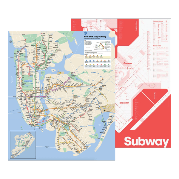
That gives you all the subway know how you need to get around the city.
Newsletter Sign Up
Daily insiders Travel Tips for selected destinations
Map of New York - Interactive Map of New York
Information about the map.
Check out the main monuments, museums, squares, churches and attractions in our map of New York. Click on each icon to see what it is.
To help you find your way once you get to your destination, the map you print out will have numbers on the various icons that correspond to a list with the most interesting tourist attractions. This way, you’ll be able to see where each attraction is.
Icons on the New York interactive map
The map is very easy to use:
- Check out information about the destination: click on the color indicators.
- Move across the map: shift your mouse across the map.
- Zoom in: double click on the left-hand side of the mouse on the map or move the scroll wheel upwards.
- Zoom out: double click on the right-hand side of the mouse on the map or move the scroll wheel downwards.
You may also be interested in
Where to eat.
It is possible to find all different types of restaurants and prices in the Big Apple. Culinary speaking, New York City isn’t expensive and it is perfectly possible to spend little when eating out.
General Information
Plan your trip to New York once you have read about its history, cultural events, top sites, boroughs and neighborhoods. Find out fascinating facts about New york and make the most of your trip.
World Map » USA » City » New York City » Manhatten Tourist Map
Manhattan Tourist Map

You may download, print or use the above map for educational, personal and non-commercial purposes. Attribution is required. For any website, blog, scientific research or e-book, you must place a hyperlink (to this page) with an attribution next to the image used.
- North America Map
- South America Map
- Oceania Map
Popular maps
- New York City Map
- Los Angeles Map
- Las Vegas Map
- Australia Map
- Germany Map
- Netherlands Map
- Singapore Map
- United Arab Emirates Map
- United Kingdom Map
- United States Map
U.S. States
- Arizona Map
- California Map
- Colorado Map
- Florida Map
- Georgia Map
- Illinois Map
- Indiana Map
- Michigan Map
- New Jersey Map
- New York Map
- North Carolina Map
- Virginia Map
- Wisconsin Map

- Extreme Spots
- Cities in 3D
- All countries

- Country selection
- Atlantic City
- Beverly Hills
- Daytona Beach
- Golden Isles
- Hawaii Islands
- Hollywood, CA
- Indianapolis
- Jacksonville
- Kansas City
- Kauai Island
- Los Angeles
- Massachusetts
- Minneapolis
- New Jersey State
- New Orleans
- Niagara Falls
- Oahu Island
- Oklahoma City
- Ontario Town
- Palm Springs
- Philadelphia
- Salt Lake City
- San Antonio
- San Francisco
- Santa Barbara
- Santa Monica
- Washington DC
Detailed hi-res maps of Manhattan for download or print
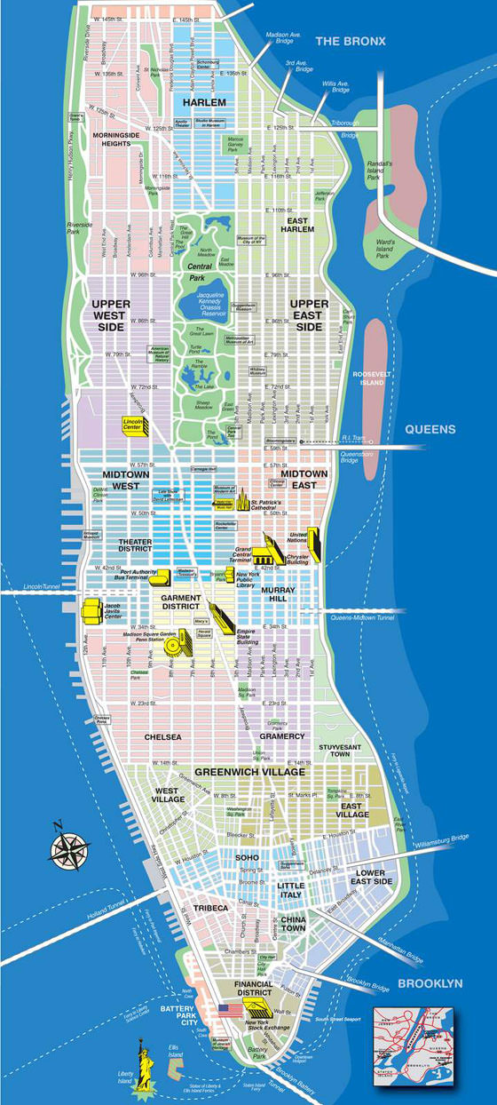
Large interactive map of Manhattan with sights/services search
City tours, excursions and tickets in manhattan and surroundings.

Search for services, infrastructure and sights on map of Manhattan

Photogallery of Manhattan sightseeing
Our guide chapters over Manhattan
Advices for travellers.
Active recreation
Weekend in manhattan in original style, shopping, streets and outlets, manhattan for children - what to visit, travel guide to manhattan, detailed maps of neighbouring cities to manhattan.

Nyc Tourist Map Printable
New York City is one of the most vibrant and exciting cities in the world to visit. With so many different neighborhoods and attractions to explore, it can be overwhelming to plan your trip. Luckily, there are plenty of tourist maps available to guide you on your adventures. Here are 10 of the best printable maps of New York City.
- Map of Manhattan

- NYC Tourist Maps Printable
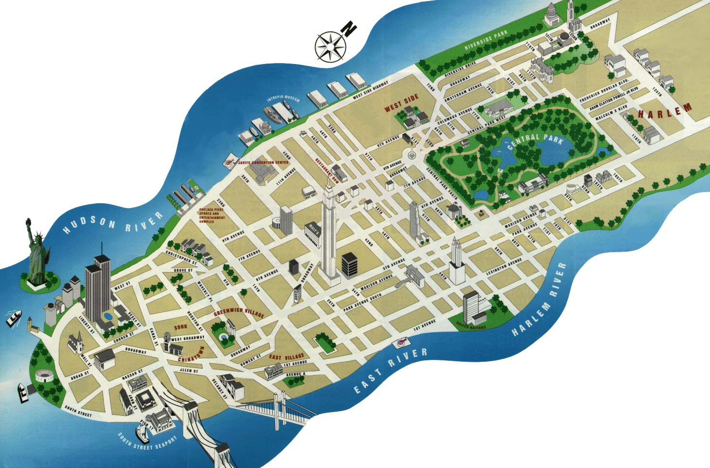
- Tourist Map of New York City Printable
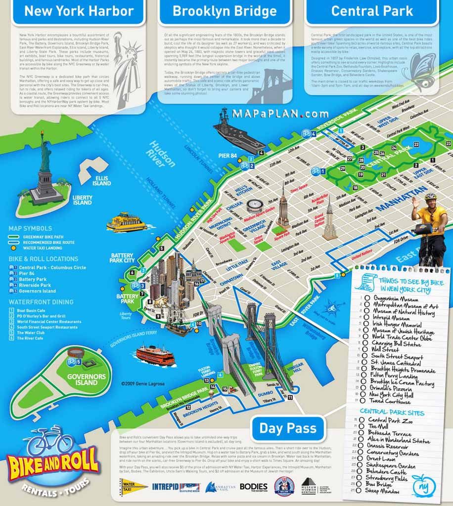
- New York City Manhattan Printable Tourist Map
- Maps of New York top tourist attractions - Free, printable

- Large printable tourist attractions map of Manhattan, New York city
- New york Attractions Map PDF
- NYC walking tourist map
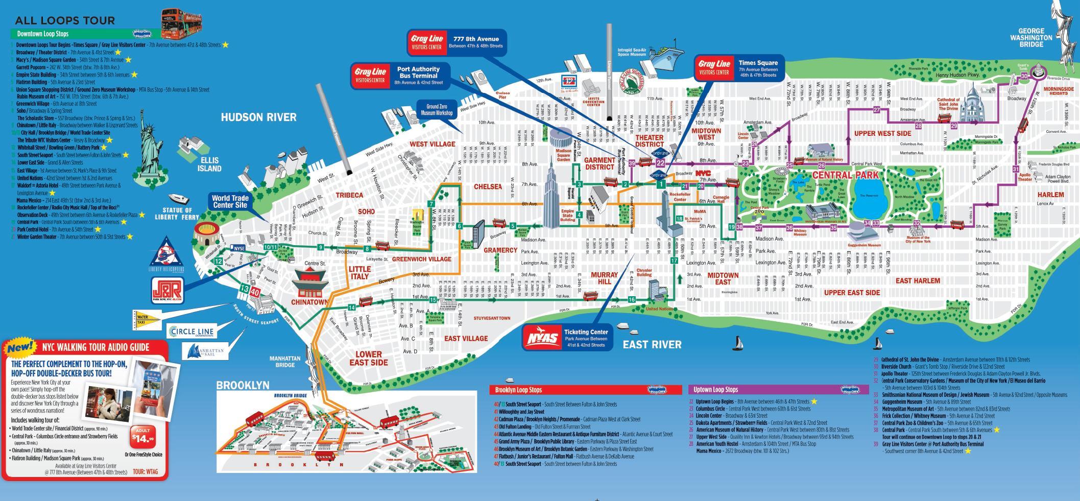
- NYC tourist map printable
- Printable Map Of Nyc Tourist Attractions
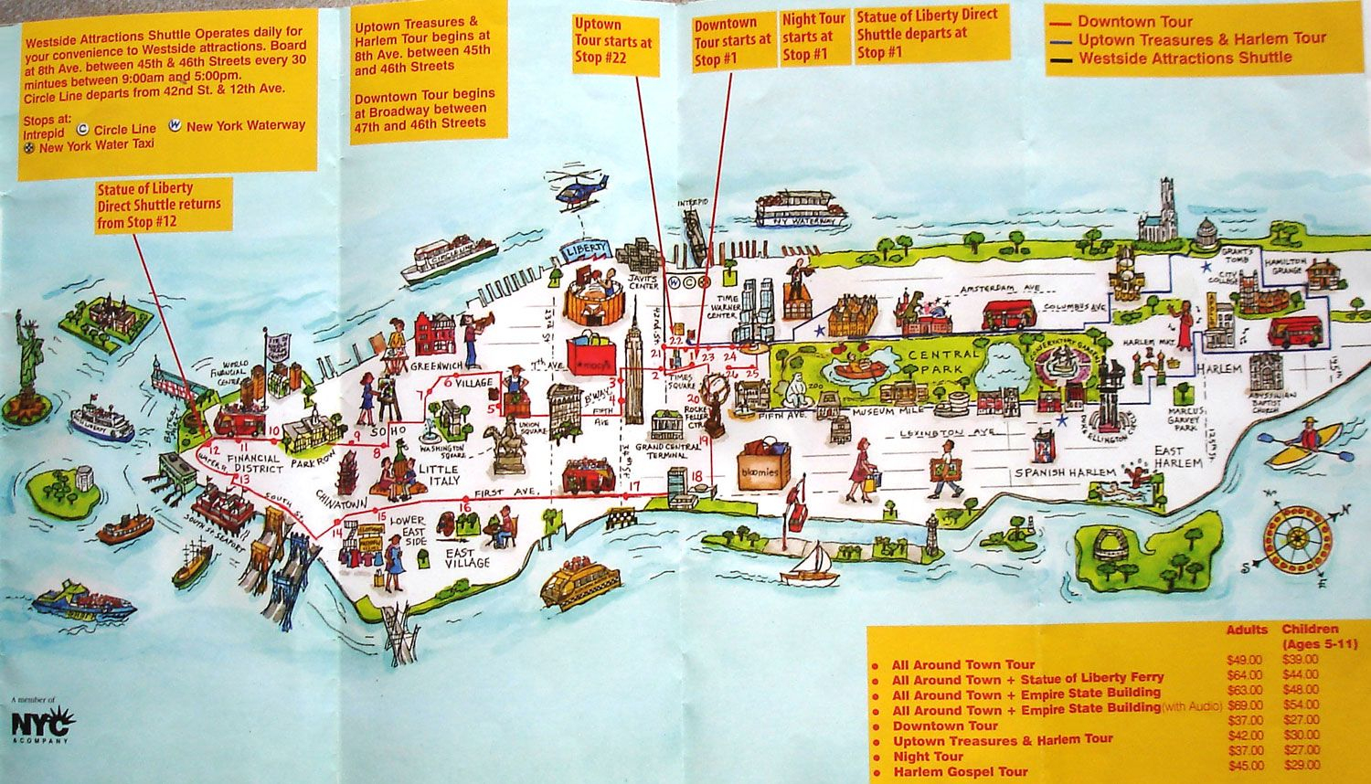
These 10 tourist maps are just a few of the many resources available to help you plan your trip to New York City. Whether you’re interested in exploring Manhattan’s top attractions or venturing out to the outer boroughs, these maps are sure to make your trip a success.
Printable Living Will Forms
Husker football printable schedule.
Welcome to Francesco's WisPost, your go-to destination for all things printable! Whether you're looking for stylish templates, creative designs, or helpful resources, we've got you covered. Our website is dedicated to providing a wide range of printable materials to enhance your personal and professional projects.
Recent Posts
Easter gift tag printable, free printable sunflower stencils, printable alphabet hand lettering fonts, get interesting news.
Subscribe to our newsletter and we’ll send you the emails of latest posts.

- Neighborhood
- Topographic

Manhattan tourist map
You can find on this page the Manhattan tourist map to print and to download in PDF. The Manhattan tourist attractions map presents the monuments, museums, parks and points of interest of Manhattan in USA.
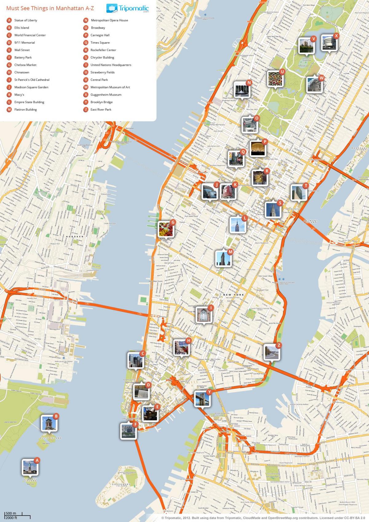
Map of Manhattan points of interest
The Manhattan sightseeing map shows all tourist places and points of interest of Manhattan. This tourist attractions map of Manhattan will allow you to easily plan your visits of landmarks of Manhattan in USA. The Manhattan tourist map is downloadable in PDF, printable and free.
Manhattan is one of New York City major tourist destination. The longest street in Manhattan is Broadway as its shown in Manhattan tourist map, where there are many different shops, shopping malls, restaurants, cafes, theaters etc. Wall Street is the main business street of the city, where the buildings of the stock exchange, banks and the financial power of the United States are concentrated.
Times Square of Manhattan is the busiest square. It is a great place to take a selfie and one of Manhattan must-see tourist sights as its mentioned in Manhattan tourist map. Climb the famous red stairs and look around, you will see many people dressed as superheroes and Disney and other famous characters. These animators will offer you to take a picture with them.
If you are planning a trip to NYC, you would be crazy not to start with the best tourist attractions of Manhattan. Though it is neither the largest or most densely populated borough (those honors belong to Queens and Brooklyn, respectively), it is the center of the city both geographically and culturally as its shown in Manhattan tourist map. In Manhattan you will find iconic tourist attractions like the Empire State Building, Statue of Liberty and Central Park, as well as some of the best restaurants in New York and all the biggest Broadway shows.
Manhattan attractions map
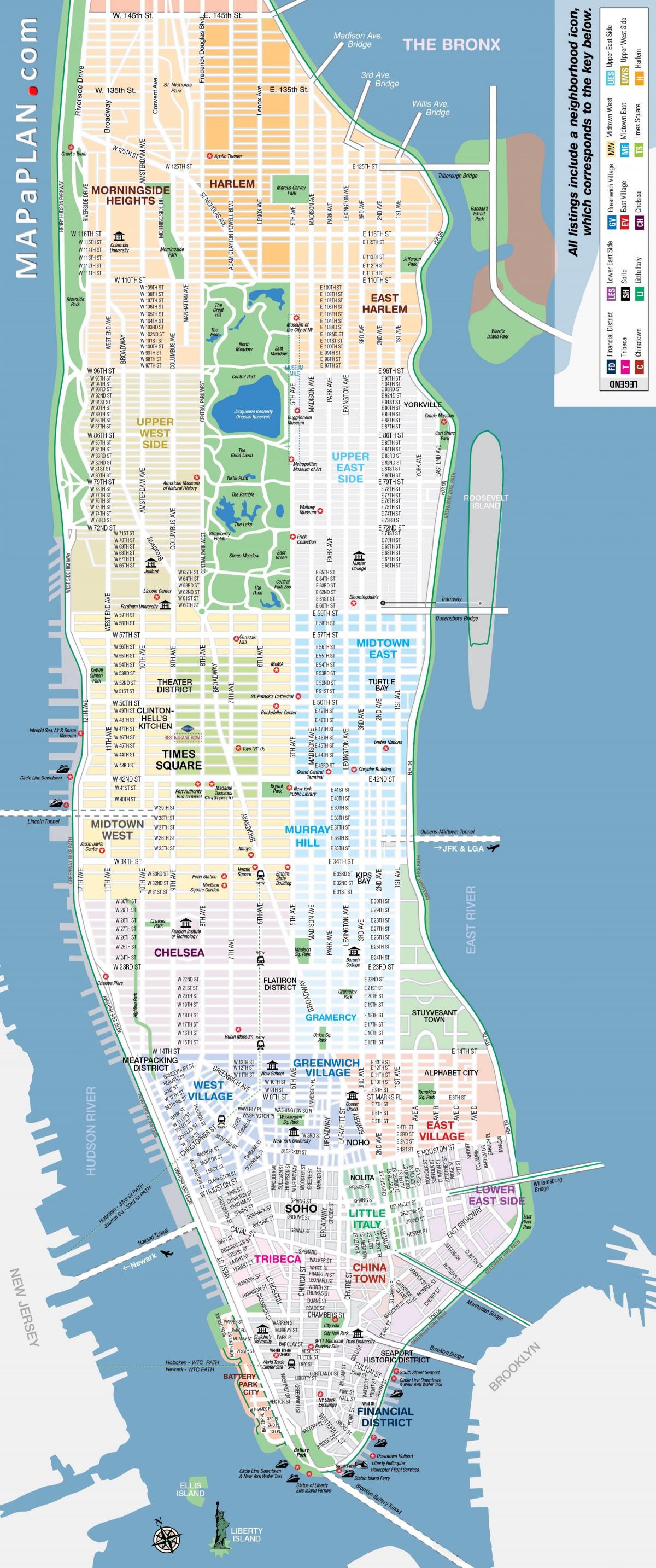
Map of Manhattan tourist places
The Manhattan attractions map shows the main monuments, museums and parks of Manhattan. This tourist places map of Manhattan will allow you to easily plan your visits of tourist attractions of Manhattan in USA. The Manhattan attractions map is downloadable in PDF, printable and free.
Manhattan has a lot of iconic attractions as you can see in Manhattan attractions map, starting from the Empire State Building to the iconic 5th Avenue, not to mention the memorable Statue of Liberty. The Empire State Building is the tallest and most famous skyscraper in Manhattan, making it one of the most important tourist attractions. It has been featured in many movies.
Central Park, is the most famous green space in the New York metropolis, contrasts with the surrounding urbanism and one of the best attractions in Manhattan. Between the East and Hudson Rivers, this haven of tranquility ayou can see in Manhattan attractions map, is the perfect opportunity to escape for a moment. You can lie down with pleasure on the freshly cut grass, surrounded by beautiful gardens.
The One World Trade Center was opened last May and became the tallest building in the Western Hemisphere of Manhattan, with an antenna height of 546 meters as its mentioned in Manhattan attractions map. While this iconic attraction of Manhattan is mainly composed of offices, the building in One World Observatory welcomes tourists to its top floor, by having them up in less than 60 seconds.
Manhattan zoo map
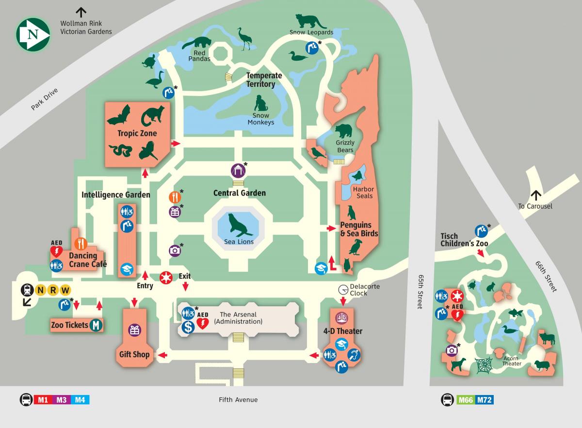
Map of Manhattan zoo park
The Manhattan zoo map shows recommended tours of the Manhattan Zoological Park. This zoo map of Manhattan will allow you to easily find out where each animal is and where to picnic in the Zoological Park of Manhattan in USA. The Manhattan zoo map is downloadable in PDF, printable and free.
In Manhattan zoo, you can see more than a hundred species of animals including California sea lions, a magnificent polar bear, red pandas found in Asia. You have to count 1 hour if you normally stop in front of the animals in Manhattan zoo. The zoo is located in southwest Central Park as its sown in Manhattan zoo map.
Animal lovers of all ages wont want to miss the Central Park Zoo of Manhattan. Manhattan zoo is a pioneer in re-creating natural habitats in urban environments, the zoo is home to some favorite species such as sea lions, brown bears, snow monkeys, snow leopards and red pandas (see Manhattan zoo map). The Manhattan zoo also offers outdoor and tented event space for private functions.
The Central Park Zoo of Manhattan is one of Central Park flagship attractions. The Manhattan zoo is home to more than 130 different species, from cheetahs to giant polar bears and small leaf-cutting ants as its mentioned in Manhattan zoo map. The Central Park Zoo of Manhattan was became famous by the animated film Madagascar, specializes in reconstructing natural habitats in Manhattan.
For Monday's solar eclipse, New York State, federal authorities issue travel alerts
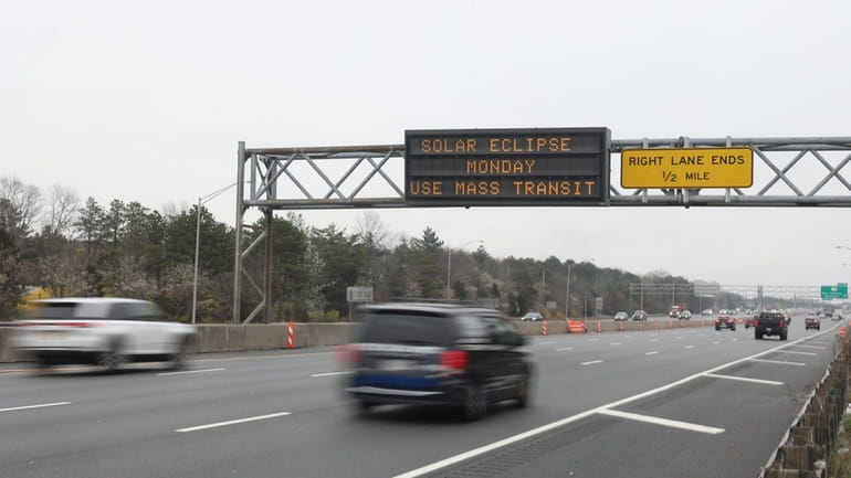
A digital sign on the eastbound LIE in Medford advises motorists of Monday's eclipse. Credit: James Carbone
If you drive the Long Island Expressway, you've probably seen the signs: “Solar eclipse Monday. Take mass transit.”
State officials are warning of traffic mayhem surrounding Monday's “Great North American Eclipse,” which will cut a 120-mile-wide swath of total darkness from Texas to Maine — including a portion of upstate New York.
It will only last for several minutes, and Long Island will reach about 90% totality. Still, statewide travel warnings have been issued that include unusually heavy traffic into Tuesday.
Suffolk police said Tuesday there were “no special preparations” being made to deal with traffic that day and Nassau police said they currently have no special advice for drivers.
But AAA issued a list of do's and don'ts for drivers, including: Keep your vehicle's headlights on; lower the visor to block your view of the sun; don't try to photograph or video the eclipse while driving; and don't pull over to the side of heavily trafficked roads to view it.
And, while NASA warns eclipse-rated glasses — thousands of times darker than normal sunglasses — are needed to safely view the eclipse, AAA reminds drivers not to wear them while driving.
The eclipse will begin over the South Pacific Ocean and cross North America beginning about 2:10 p.m. Eastern Daylight Time and ending at about 4:36 p.m., transiting over Mexico, the United States and Canada.
In New York, the path of totality will cover a host of upstate areas, officials said, the largest among them Jamestown, Buffalo, Rochester, Syracuse, Watertown and Plattsburgh.
Officials said tens of thousands have booked stays in many upstate locations in the eclipse path, including a host of small rural towns and villages.
That's where the bulk of any traffic concerns come in, with state officials warning of overburdened roads in locations not designed to handle it.
“Travelers are encouraged to arrive at their destination early and leave well after the eclipse has ended,” officials said in a notice posted to the state Department of Transportation 511 NY website.
In fact, AAA said its official car rental partner, Hertz, reported a 3,000% increase in advance bookings for locations in the projected eclipse path, with rentals beginning Saturday. Hotels in the eclipse path are reportedly 48% more expensive on average for eclipse weekend, AAA said.
Even the Federal Aviation Administration is warning of potential air travel delays, citing “possible impacts to air traffic and airports along the eclipse path” between 6 a.m. Sunday and Wednesday, April 10.
The National Weather Service is calling for sunny skies on Long Island and about 60 degrees Monday.

John Valenti, a reporter at Newsday since 1981, has been honored nationally by the Associated Press and Society of the Silurians for investigative, enterprise and breaking news reporting, as well as column writing, and is the author of “Swee'pea,” a book about former New York playground basketball star Lloyd Daniels. Valenti is featured in the Emmy Award-winning ESPN 30-for-30 film “Big Shot.”
World Atlas names 9 of New York's most picturesque small towns. See the list

We all love to visit that picture-perfect place and snap photos to share with family and friends. World Atlas , a website publishing content about resources and entertainment on geography, has revealed nine of New York's most picturesque towns, including two within the Finger Lakes region.
Small towns with charm dot the New York landscape, each with its own charm, natural beauty and colorful communities. Here are the nine most picturesque small towns in New York, as determined by the World Atlas.
Lake Placid NY
This village in the Adirondacks was a two-time host of the winter Olympics and serves as an all-around sports meccca from skiing to triathlons, and from skating to hiking. Lake Placid sits on the southern shores of a lake by the same name and surrounds the much smaller Mirror Lake. Numerous wooded hikes start from trails in the village, which is also known for a wide array of quaint shops and restaurants.
Sleepy Hollow NY
Sleepy Hollow , located in Westchester County and 25 miles north of New York City, is best known for being the main inspiration for Washington Irving's “The Legend of Sleepy Hollow.” There are also several natural attractions nearby, including Nyack Beach State Park and Rockefeller State Park Preserve , as well as historic sites including the Philipsburg Manor and the Sleepy Hollow Cemetery, where Irving and many other notable souls were laid to rest .
Watkins Glen NY
Home to Watkins Glen State Park and its spectacular gorges and hiking trails, Watkins Glen is in Schuyler County at the southern end of Seneca Lake. Stroll on the boardwalk of Seneca Lake Pier before stopping for a bite at a lakeside eatery.
New Paltz NY
Located by the Wallkill River and beneath the jaw-dropping Shawangunk Ridge, this Ulster County town is painted with many different colors. For starters, New Paltz was settled by French Huguenots in the early 18th century. Seven original stone houses and one church stand on historic Huguenot Street – a National Historic Landmark District. Nearby is the Mohonk Preserve , where 70 miles of carriage roads and hiking/biking/horseback riding trails cover the northern Sawangunk Ridge. Also nearby is the Mohonk Mountain House – a world-famous resort at the northern tip of Mohonk Lake.
Kingston NY
Located in Ulster County, Kingston was once the capital of the Empire State. Today, Kingston's Stockade National Historic District, now a business district, still has nearly two dozen 18th century limestone houses. The neighborhood is on national state and local registers for historic places. Kingston is also home to the Hudson River Maritime Museum , a sandy public beach and the Rondout Lighthouse .
Saugerties NY
Situated between the Hudson River and Catskill Park, in Ulster County, Saugerties is a haven for adventure while not being overly inundated with droves of tourists. The Catskill Animal Sanctuary, Falling Waters Preserve and Esopus Creek Conservatory, are all located here. The Saugerties Lighthouse, which still operates, also now doubles as a bed and breakfast. Saugerties is also home to a quintessential small-town commercial district, which sprawls across the highly walkable Main and Partition Streets.
Woodstock NY
Located in Ulster County in the Catskill Mountains , Woodstock is best known for lending its name to a particularly famous music festival in 1969, even though the festival actually took place 40 miles away in Bethel, Sullivan County. "Today, Woodstock provides a variety of great opportunities to explore the boundless outdoors," according to the World Atlas. Overlook Mountain and Catskill Center Thorn Preserve are both nearby. Mower’s Flea Market , which is open every weekend, is also wildly popular. There are also loads of performing arts centers, galleries and museums.
Montauk , the easternmost community on Long Island, is known for its many beaches and pristine coastal parks, boating, paddling, fishing, as well as its luxury accommodations and fine dining, according to the World Atlas. Montauk is also home to the Montauk Point Lighthouse, built in 1796 and the oldest such beacon in New York and the fourth-oldest in the nation.
Skaneateles NY
Skaneateles , with its unique shops and restaurants, sits astride the northern tip of Skaneateles Lake in Onondaga County. Home to Carpenter Falls and Bahar Nature Preserve and of course Skaneateles Lake, the town is an outdoor enthusiast’s dream. Skaneateles Lake is considered to be one of the highest Finger Lakes, at almost nine hundred feet above sea level, and there are also several parks in Skaneateles, including Cliff Park, Thayer Park and Shotwell Memorial Park. The town also boats a quaint historic district, which hosts a Charles Dickens-themed festival each December. The historic district boasts a wealth of well-preserved 19th century buildings and has been a part of the National Register of Historic Places since 1984.

2024 solar eclipse: 'New' path of totality map reveals Ohio will see less of the solar eclipse
Editor's note: This story has been updated to note NASA does not plan to change its calculations for the eclipse.
A total solar eclipse will cross North American skies on April 8, and Ohio residents will have a once-in-a-lifetime opportunity to view it.
But now, fewer Ohioans will experience 100% darkness during the 2024 solar eclipse.
Start the day smarter. Get all the news you need in your inbox each morning.
That's because, despite modern technology, the sun's radius is difficult to measure. New data shows that the sun is a tad bigger than previously thought. These new calculations have slightly shifted the solar eclipse's path of totality – just a week before the event.
Expert John Irwin has recently published a new map with updated lines for the April 8 solar eclipse, Forbes reported . The sun's morphing size and changes in the moon's surface mean no two eclipses are the same, but NASA's projections for the 2024 eclipse aren't changing.
Solar eclipse map: Updated path of totality in Ohio
The red lines shown below represent the original path of totality, while the orange lines show the path updated with the new data – which predicts a narrower path of totality for Ohio.
Zoom in on Ohio to see if you'll be inside the path of totality during the eclipse on April 8.
The path of totality will fall over Dublin, just a few miles north of Columbus
Ohio will get a slightly narrower path of totality by nearly a half mile on each side of the path, according to the new calculation. That shifts the fullest effects of the eclipse away from two of the state's largest cities.
Columbus remains outside the path of totality, but a few suburbs north of the city land on the path to experience complete darkness. Dublin still falls inside the path of totality, but nearby areas won't experience 100% darkness.
Riverlea now falls outside the path of totality, as does downtown Westerville, though the Otterbein University campus will straddle the path of totality.
On I-270, the exit at Cemetery Road was once inside the path of totality, but now sits just outside of it, based on the new data.
The eclipse will shift slightly further away from Cincinnati
The new path of totality moves the fullest eclipse experience away from downtown Cincinnati, just as it does for Columbus.
In Liberty Township, for example, St. Maximilian Kolbe Parish sat inside the path of totality while nearby Center Pointe Christian Church was on the other side. Now, both fall outside the path of totality.
Downtown Canton is also further away from the full eclipse experience
Downtown Canton was never projected to be inside the path of totality, but the new data projects complete darkness to fall further away from the city. However, North Canton remains inside the zone set to experience 100% darkness.
Massillon sat comfortably inside the path of totality, but the new projections show the eclipse's shadow falling north of downtown.
Akron, Cleveland, Dayton, Toledo, other Ohio cities remain the path of totality
The new projections for the path of totality won't change the eclipse experience much for viewers close to the other big cities.
Akron, Cleveland, Dayton and Toledo will enjoy the full eclipse experience. So too will Ashland, Bucyrus, Mansfield, Marion and Sandusky.
What NASA says about the 'new' eclipse path of totality map
In speaking with the Detroit Free Press , NASA spokesman Tiernan Doyle acknowledged that even though the space agency is sticking with its original eclipse outlook in 2024, it aims to refine its eclipse predictions in the future by potentially taking into account the "topography of both the moon and the Earth."
Doyle added that there may be "a tiny but real uncertainty about the size of the sun," which could "yield an eclipse path that is slightly narrower."
And, he said, "uncertainty in the Earth’s rotation can also affect eclipse predictions on this level. Traveling toward the center of the path of totality – even a mile or two – will quickly increase the length of totality that people can see."
Whether or not the new path of totality is the correct one or the original prediction holds true, the overall difference would be minimal. As Doyle told the Free Press, "(It) would only affect cities on the very edge of the path of totality, where blanket predictions are difficult regardless – a few city blocks one way or the other could mean 20, 10, or zero seconds of totality."
Austin American-Statesman reporter Alexis Simmerman and Detroit Free Press reporter Frank Witsil contributed to this report .
Try for a high score on our Cincinnati Zoo quiz
This article originally appeared on Cincinnati Enquirer: 2024 solar eclipse: 'New' path of totality map reveals Ohio will see less of the solar eclipse
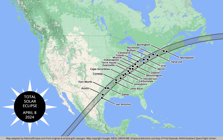
- Share full article
Advertisement
Supported by
New York Takes Crucial Step Toward Making Congestion Pricing a Reality
The board of the Metropolitan Transportation Authority voted to approve a new $15 toll to drive into Manhattan. The plan still faces challenges from six lawsuits before it can begin in June.

By Winnie Hu and Ana Ley
New York City completed a crucial final step on Wednesday in a decades-long effort to become the first American city to roll out a comprehensive congestion pricing program, one that aims to push motorists out of their cars and onto mass transit by charging new tolls to drive into Midtown and Lower Manhattan.
The program could start as early as mid-June after the board of the Metropolitan Transportation Authority, the state agency that will install and manage the program, voted 11-to-1 to approve the final tolling rates, which will charge most passenger cars $15 a day to enter at 60th Street and below in Manhattan. The program is expected to reduce traffic and raise $1 billion annually for public transit improvements.
It was a historic moment for New York’s leaders and transportation advocates after decades of failed attempts to advance congestion pricing even as other gridlocked cities around the world, including London, Stockholm and Singapore, proved that similar programs could reduce traffic and pollution.
While other American cities have introduced related concepts by establishing toll roads or closing streets to traffic, the plan in New York is unmatched in ambition and scale.
Congestion pricing is expected to reduce the number of vehicles that enter Lower Manhattan by about 17 percent, according to a November study by an advisory committee reporting to the M.T.A. The report also said that the total number of miles driven in 28 counties across the region would be reduced.
“This was the right thing to do,” Janno Lieber, the authority’s chairman and chief executive, said after the vote. “New York has more traffic than any place in the United States, and now we’re doing something about it.”
Congestion pricing has long been a hard sell in New York, where many people commute by car from the boroughs outside of Manhattan and the suburbs, in part because some of them do not have access to public transit.
New York State legislators finally approved congestion pricing in 2019 after Gov. Andrew M. Cuomo helped push it through. A series of recent breakdowns in the city’s subway system had underscored the need for billions of dollars to update its aging infrastructure.
It has taken another five years to reach the starting line. Before the tolling program can begin, it must be reviewed by the Federal Highway Administration, which is expected to approve it.
Congestion pricing also faces legal challenges from six lawsuits that have been brought by elected officials and residents from across the New York region. Opponents have increasingly mobilized against the program in recent months, citing the cost of the tolls and the potential environmental effects from shifting traffic and pollution to other areas as drivers avoid the tolls.
A court hearing is scheduled for April 3 and 4 on a lawsuit brought by the State of New Jersey, which is seen as the most serious legal challenge. The mayor of Fort Lee, N.J., Mark J. Sokolich, has filed a related lawsuit.
Four more lawsuits have been brought in New York: by Ed Day, the Rockland County executive; by Vito Fossella, the Staten Island borough president, and the United Federation of Teachers; and by two separate groups of city residents.
Amid the litigation, M.T.A. officials have suspended some capital construction projects that were to be paid for by the program, and they said at a committee meeting on Monday that crucial work to modernize subway signals on the A and C lines had been delayed.
Nearly all the toll readers have been installed, and will automatically charge drivers for entering the designated congestion zone at 60th Street or below. There is no toll for leaving the zone or driving around in it. Through traffic on Franklin D. Roosevelt Drive and the West Side Highway will not be tolled.
Under the final tolling structure, which was based on recommendations by the advisory panel, most passenger vehicles will be charged $15 a day from 5 a.m. to 9 p.m. on weekdays, and from 9 a.m. to 9 p.m. on weekends. The toll will be $24 for small trucks and charter buses, and will rise to $36 for large trucks and tour buses. It will be $7.50 for motorcycles.
Those tolls will be discounted by 75 percent at night, dropping the cost for a passenger vehicle to $3.75.
Fares will go up by $1.25 for taxis and black car services, and by $2.50 for Uber and Lyft. Passengers will be responsible for paying the new fees, and they will be added to every ride that begins, ends or occurs within the congestion zone. There will be no nighttime discounts. (The new fees come on top of an existing congestion surcharge that was imposed on for-hire vehicles in 2019.)
The tolls will mostly be collected using the E-ZPass system. Electronic detection points have been placed at entrances and exits to the tolling zone. Drivers who do not use an E-ZPass will pay significantly higher fees — for instance, $22.50 instead of $15 during peak hours for passenger vehicles.
Emergency vehicles like fire trucks, ambulances and police cars, as well as vehicles carrying people with disabilities, were exempted from the new tolls under the state’s congestion pricing legislation .
As for discounts, low-income drivers who make less than $50,000 annually can apply to receive half off the daytime toll after their first 10 trips in a calendar month. In addition, low-income residents of the congestion zone who make less than $60,000 a year can apply for a state tax credit.
All drivers entering the zone directly from four tolled tunnels — the Lincoln, Holland, Hugh L. Carey and Queens-Midtown — will receive a “crossing credit” that will be applied against the daytime toll. The credit will be $5 round-trip for passenger vehicles, $12 for small trucks and intercity and charter buses, $20 for large trucks and tour buses, and $2.50 for motorcycles. No credits will be offered at night.
Grace Ashford contributed reporting.
Winnie Hu is a Times reporter covering the people and neighborhoods of New York City. More about Winnie Hu
Ana Ley is a Times reporter covering New York City’s mass transit system and the millions of passengers who use it. More about Ana Ley

IMAGES
VIDEO
COMMENTS
The Insider Guide also includes a Manhattan Neighborhood map with details like how many street blocks are in a mile, how the New York City avenues and streets run, and a NYC Subway map to coordinate with each neighborhood. West Village, SoHo, Tribeca/Battery Park City, Financial District/ Wall Street, Chinatown, Little Italy and more.
Below is a list of the 12 maps of New York you'll find in this article. You can print them out or save them on your smartphone so you can check them at any time. New York tourist map. New York interactive map. Manhattan map. Map of the main attractions in New York. Central Park map. New York street map.
Take our free printable map of New York City on your trip and find your way to the top sights and attractions. We've designed this NYC tourist map to be easy to print out. It includes 26 places to visit in Manhattan, clearly labelled A to Z. Starting with the Statue of Liberty up to to the renowned museums in Central Park, NY. With this ...
Download. Print. Get App. Interactive map of New York City with all popular attractions - Times Square, Empire State Building, Brooklyn Bridge and more. Take a look at our detailed itineraries, guides and maps to help you plan your trip to New York City.
The Brooklyn Bridge, built between 1869 and 1883, connects Manhattan with New York. The bridge is one of the most magnificent tourist attractions in New York. The impressive bridge spans the East river between Brooklyn and Manhattan and stretches for a length of 5989 ft, about 1.8 km. The length between the large towers is 1595.5 ft (486 meter).
The Streetwise Manhattan map is my top choice for visitors to New York City. It has a sturdy laminated finish, making it easy to fold and resilient enough to survive repeat trips to New York City. We especially like the compact size of this map -- unfolded it is only the size of a piece of legal paper. The index covers neighborhoods, places of ...
Get the free printable map of New York Printable Tourist Map or create your own tourist map. See the best attraction in New York Printable Tourist Map. Česká republika Deutschland United States España France Italia 대한민국 Nederland Polska Brasil Россия Slovensko Türkiye 中国
New York City Tourist Map: Mapping Your Itinerary. To make the most of your New York visit, a detailed map is your best companion. Begin with an interactive map that allows you to not only view all the iconic landmarks but also customize your route. Pinpoint attractions, estimate walking distances, and even set time aside for spontaneous exploration.
Nyc sightseeing map. Print Download PDF. In New York City you can visit: museums: Guggenheim Museum, Ellis Island Immigration Museum, American Museum of Natural History, Museum of Modern Art (MoMA) monuments: Statue of Liberty. neighborhoods: Soho, Chinatown, Little Italy. squares: Times Square.
Map of New York to print: the city map. First of all, you can download the New York City official map by clicking here. You can even print it from home! I strongly recommend it, because it is very well done. In fact, you will find a list of the main attractions and their location on the map. The main tourist attractions are in Manhattan and ...
The map contains information of the city's famous sites, such as the , , Central Park, Brooklyn Bridge, historic neighborhoods, and some of the city's best museums. Our goal is to help every traveler in New York to easily navigate the city. Thus, we have provided different types of maps for that tourists can use for free, such as the New York ...
NYC Maps & Travel Guides. Visiting New York for the first time can be a life changing experience. It's a good idea to do a bit of research in advance - familiarize yourself with your local transit routes, nearby attractions and sightseeing bus stops so that the beginning of each day of discovery won't start with a panic to find where to begin.
Icons on the New York interactive map. The map is very easy to use: Check out information about the destination: click on the color indicators. Move across the map: shift your mouse across the map. Zoom in: double click on the left-hand side of the mouse on the map or move the scroll wheel upwards. Zoom out: double click on the right-hand side ...
Our interactive and printable New York City tourist map is the best tool for a stress-free adventure; Our map is user-friendly and provides accurate and up-to-date information; Download the New York City Tourist Map of attractions. Top Tourist Spots in New York City. When visiting New York City, it's impossible to miss the incredible ...
Description: This map shows visitor information centers, tourist routes, points of interest and sightseeings in Manhattan, New York City.
Detailed and high-resolution maps of Manhattan, USA for free download. Travel guide to touristic destinations, museums and architecture in Manhattan.
Manhattan, New York city large detailed printable tourist attractions map. Large detailed printable tourist attractions map of Manhattan, New York city.
Maps of New York top tourist attractions - Free, printable This free and printable map includes all of the top tourist attractions in New York City, from the Statue of Liberty to the 9/11 Memorial. It's a great resource for planning your trip and making sure you don't miss any must-see sights.
The Manhattan tourist map is downloadable in PDF, printable and free. Manhattan is one of New York City major tourist destination. The longest street in Manhattan is Broadway as its shown in Manhattan tourist map, where there are many different shops, shopping malls, restaurants, cafes, theaters etc. Wall Street is the main business street of ...
Even the Federal Aviation Administration is warning of potential air travel delays, citing "possible impacts to air traffic and airports along the eclipse path" between 6 a.m. Sunday and Wednesday ...
By Peter Eavis and Jenny Gross. March 26, 2024. The Baltimore bridge disaster on Tuesday upended operations at one of the nation's busiest ports, with disruptions likely to be felt for weeks by ...
Updated April 2, 2024. On April 8, the moon will slip between the Earth and the sun, casting a shadow across a swath of North America: a total solar eclipse. By cosmic coincidence, the moon and ...
NEWS. World Atlas names 9 of New York's most picturesque small towns. See the list. Victoria E. Freile. Rochester Democrat and Chronicle. We all love to visit that picture-perfect place and snap ...
The path of 2024 solar eclipse just moved a little bit farther from Canton, Cincinnati and Columbus as Ohio's area of totality shrinks based on new data. Travel news Cincinnati Enquirer
Flatiron/ Union Square. Statue of Liberty Ellis Island. 6-9 minutes by subway. nycinsiderguide.com, v. 2021. Guggenheim Museum. Metropolitan Museum of Modern Art. Frick Collection.
Fares will go up by $1.25 for taxis and black car services, and by $2.50 for Uber and Lyft. Passengers will be responsible for paying the new fees, and they will be added to every ride that begins ...
Results from the 2024 New York presidential and congressional primaries.